
EU-IP PREVIEW / Prevention, information and early warning pre-operational services to support the management of risks - Precipitation and Runoff forecasts
- Contact:
Prof. Dr. M. Kunz
- Project Group: IMK-TRO
- Funding: EU
Integrated Project EU
WP: Short Range Flood Forecast
WP: Medium Range Flood Forecast
Overview
Effective operational flood management requires detailed knowledge of the distribution of precipitation at high spatial and temporal resolution. Especially with regard to the run-off characteristics of a flood peak, high-quality data is demanded.
It is the goal to achieve more precise flood forecasts through a better identification of precipitation fields and in turn permits adequate and well adapted prevention measures. For these purposes spatial and temporal highly resolved precipitation data will be derived by means of nested simulations of the Local Model (LMK) of the German weather service (DWD). It is expected that the intended spatial resolution of the model at about 1 km leads, on the one hand, to a more realistic representation of the topography as well as an improvement of the quantitative precipitation forecast due to explicitly resolved convection. On the other hand, a scale jump between meteorological and hydrological modeling may be avoided at this scale.
The IMK is involved in two so-called work packages (WPs) within the project PREVIEW. The goal of both packages is to improve flood forecasting, but on different time scales. The WP `Short Range Flood Forecast' (WP-SRFF) aims at a forecasting period of 1--3 days, whereas the WP `Medium Range Flood Forecast' (WP-MRFF) aims at a period of 3--10 days.
In WP-SRFF highly resolved precipitation fields (1 km) will be provided by the model for the more limited catchment Iller (southwestern Bavaria). In close cooperation with hydrological and hydraulical groups, an attempt is made to find out any difficulties in predicting floods in such a relatively small, but high-risk, catchment. In an effort to quantify any uncertainties in the model caused by its initial conditions, the model will be initialized by a number of selected members of the ensemble prediction system called COSMO-LEPS. Initially, various flooding relevant precipitation events will be simulated to validate the used flooding models (LARSIM and WAVOS) and to adjust single component therein. Following this initializing test phase, the system will subsequently be operating in a quasi-operational mode until the end of duration time of the project (2008).
In WP-MRFF the water cycle of almost the complete Danube catchment is simulated by various meteorological and hydrological models. Spatial resolutions of the meteorological models vary between 1 km (IMK-LMK), 7 km (DWD-LM), 10 km (COSMO-LEPS), 40 km (DWD-GME), and 60 km (ECMWF). Additionally, two hydrological models are applied side by side (JRC-LISFLOOD and VITUKI-TAPI). This variety of spatial resolutions enables the partners to focus on general precipitation patterns and local precipitation structures at the same time. The common simulation period was agreed to be 20 Juli -- 20 August 2002. The high spatial resolution of 1 km and relatively long period of 31 days forces the IMK to reduce the study area to the German part (maybe the Austrian part as well) of the Danube catchment (Buizza et al., 2007).
Buizza, R., Asensio, H., Balint, G., Bartholmes, J., Bliefernicht, J., Bogner, K., Chavaux, F., de Roo, A., Donnadille, J., Ducrocq, V., Edlund, C., Kotroni, V., Krahe, P., Kunz, M., Lacire, K., Lelay, M., Marsigli, C., Milelli, M., Montani, A., Pappenberger, F., Rabufetti, D., Ramos, M.-H., Ritter, B., Schipper, J. W., Steiner, P., Thielen-Del Pozzo, J., and Vincendon, B., 2007: EURORISK/PREVIEW report on the technical quality, functional quality and forecast value of meteorological and hydrological forecasts. ECMWF Research Department Technical Memorandum n. 516, ECMWF, Shinfield Park, Reading RG2-9AX, UK.
 |
|
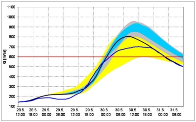
Possible distribution of the runoff values for an ensemble of meteorological initial values. |
 |
|
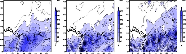
Simulated distribution of precipitation by the COSMO-model in southern Germany between 11th August 6:00 and 12th August 6:00 with a horizontal resolution of 7 km (left), 2.8 km (middle) and 1 km (right). |
Partner:
BfG – Bundesanstalt für Gewässerkunde, Koblenz
Infoterra GmbH, Friedrichshafen
JRC – Joint Research Centre, Ispra
EADS – ASTRIUM, Toulouse