
GO4ICE - Geophysical Observation and 4-Phase Modelling of Ice Content Evolution
- Contact: Dr. C. Hauck
- Project Group: IMK-TRO
- Funding:
BAFU Schweiz
Geophysical Observation and 4-Phase Modelling of Ice Content Evolution
Bitte besuchen Sie dazu folgende Webseite: www.go4ice.de
Project Description
![]()
Aim:
Quantitative assessment of permafrost degradation in the Swiss Alps using geophysical monitoring systems
Principal Investigator:
Dr. Christian Hauck (Institute for Meteorology and Climate Research, University of Karlsruhe/ Forschungszentrum Karlsruhe)
Diploma Student:
Mathias Bach (Geophysical Institute, University of Karlsruhe)
PhD student:
Dipl.-Geogr. Christin Hilbich (Department of Geography, University of Jena)
In cooperation with:
Prof. Dr. Roland Mäusbacher (Department of Geography, University of Jena)
Permafrost Monitoring Switzerland PERMOS (Dr. D. Vonder Mühll, University of Basel)
Department of Geography, University of Zürich (Prof. W. Haeberli, Dr. M. Hoelzle)
Department of Geography, University of Fribourg (Dr. R. Delaloye)
Abstract
A climate induced warming of the atmospheric surface layer and a corresponding increase of ground temperatures will lead to substantial changes in the water and energy balance of regions underlain by permafrost. In particular after the rock fall events during the hot summer 2003 it is expected that melting permafrost in steep slopes and rock faces will lead to increased activity of rock falls and debris flows. Common monitoring techniques are primarily based on thermal aspects of permafrost degradation. Concerning the stability of slopes as well as energy balance calculations related to permafrost distribution and evolution modeling it is recognized, that not only the temperature but also the ice content of the subsurface plays an important role.
Within the framework of the project GO 4 ICE (in close cooperation with PERMOS) a geophysical monitoring network has been installed during the summer months of 2005 and 2006 at 5 different permafrost observation sites in the Swiss Alps.
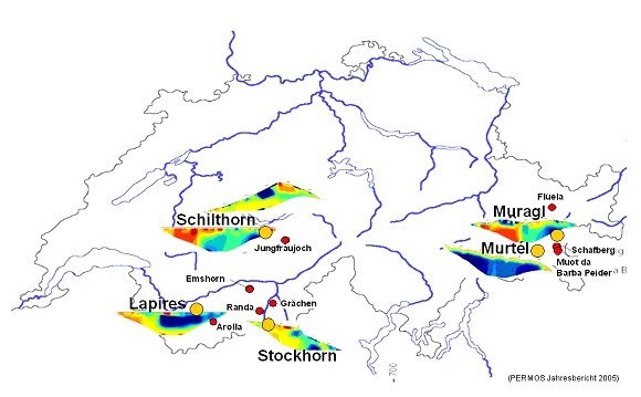 |
| Fig. 1: The geophysical monitoring network at 5 permafrost observation sites in the Swiss Alps: rockglaciers Murtél and Muragl in the Upper Engadine, talus slope Lapires and rock plateau Stockhorn in the Wallis, and 2 monitoring profiles in the north facing slope and across the crest of the Schilthorn in the Bernese Alps. |
The overall aim is a long term observation of permafrost evolution and, in particular, the quantitative assessment of mountain permafrost degradation. The monitoring network enables the observation of permafrost evolution in
a) different geographical and climatic regions of the Swiss Alps (Wallis, Engadine, Bernese Alps),
b) at morphological different sites (steep north- and south facing slopes, summit ridge, rock plateau, talus slope, rockglacier), and
c) at sites with low and high ice contents.
Based on the results of a 7 years pilot study at Schilthorn (Bernese Alps) a long term observation and quantification of the ice content at 5 permafrost sites is intended using a semi-automatic electrical resistivity tomography (ERT) monitoring system (HAUCK 2002). This assessment of permafrost degradation will be conducted with non-invasive techniques and without additional information from boreholes by combining ERT with refraction seismic measurements and a newly developed model to quantify all 4 phases of the subsurface (ice, water, air, rock/debris) (HAUCK et al. 2005). However, borehole temperature data for a minimum depth of 20 m and maximal depths of 100 m are available for model validation and data comparison at all sites.
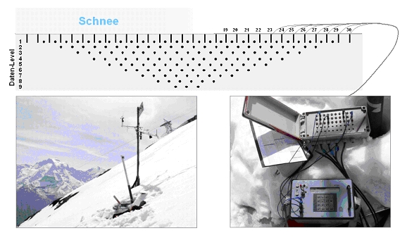 |
| Fig. 2: Measuring principle of the ERT monitoring: a fixed electrode array with buried cables is connected to a manual switch box (down right). An ERT measurement is realised by connecting a resistivity meter to the switch box and plugging the respective quadrupoles of the required configuration. The advantages of this technique are comparable general conditions and the possibility of resistivity measurements throughout the year (even under snow). |
Furthermore, the development of new measurement configurations or –geometries is planned to determine the permafrost distribution in steep topographies (rock faces and summit ridges) to account for the strong heterogeneity of mountain permafrost.
The results of the pilot study at Schilthorn already documented a substantial decrease of ground ice as a consequence of the summer 2003, which could not be fully compensated during the following years.
In addition, first results from the newly installed monitoring sites show a considerable increase of active layer depth within the last 5 – 8 years, partly up to several meters (based on previous measurements at the same locations).
Publications (in prep):
Hilbich, C., C. Hauck, M. Scherler, L. Schudel, I. Völksch, M. Hoelzle & D. Vonder Mühll (in prep.): Long-term Electrical Resistivity Tomography Monitoring of Permafrost Evolution in the Swiss Alps: an example from Schilthorn (Bernese Alps).-