Extratropical Transition of tropical cyclones: representation in Ensemble Forecasts
- Contact: D. Anwender
- Project Group: Modelling and hazard analysis of weather systems
| Title | Image | Source | Short Description |
|---|---|---|---|
| Diagnosing the Extratropical Transition of Tropical Cyclones using Ensemble Forecast | EGU General Assembly, Vienna, Austria, 24.-29.4.2005 (Poster) | ||
| Predictability associated with the Downstream Impacts of the Extratropical Transition (ET) of Tropical Cyclones | 27th Conference on Hurricanes and Tropical Meteorology. Monterey, CA, USA, 24.-28.04.2006 (Poster) |
Description
Motivation
Almost 50% of all tropical cyclones in the Northern Hemisphere move into the region of influence of the midlatitudes. They undergo a structural change and can transform into extratropical storms (extratropical transition = ET). Through their synoptic-scale influence on the midlatitude flow such systems present a threat not only to the countries where they make landfall, but are associated also with the development of severe weather on the eastern side of the ocean basins in which they form. Thus a hurricane in the western North Atlantic can play a crucial role in the development of a European wind storm or severe flooding event.
The relatively small scales of tropical cyclones and the complex physical processes that occur during an interaction of a tropical storm with the midlatitude flow present a severe challenge for numerical weather prediction. An ET event can reduce the accuracy of the medium range weather forecast downstream of tropical cyclones considerably leading to pour forecasts for Europe and western North America. Guidance with respect to the uncertainty associated with ET can be obtained from ensemble prediction systems (EPS). This approach aims to find the regions in the atmosphere in which analysis errors grow rapidly. This is carried out through small perturbations in the analysis. An ensemble of forecasts is calculated from these perturbed analysies and from the unperturbed analysis. In addition uncertainty associated with the model physics is considered by the inclusion of stochastic physics.
Method and case studies
The representation of selected ET cases in the EPS of the ECWMF is investigated and a measure of the relative predictability of ET events is provided. A spaghetti plot of the ensemble forecast of the 500 hPa geopotential (Fig. 1 top) shows a high variability in the ensemble members associated with the ET of Maemi (2003) (black dot) what gives a hint that the predictability downstream of the ET event is quite low. The uncertainty can be quantified with a Hovmoellerplot of the standarddeviation of the 500 hPa geopotential in the ensemble members of the EPS (Fig. 1 bottom).
|
|
|
Fig. 1: ECMWF EPS forecast from 10 September 2003 12 UTC valid for 10 days. Top: Spaghettiplot of the 500 hPa geopotential. Bottom: Hovmoeller diagram of the standard deviation (m) of the 500 hPa geopotential. The ETs of Maemi and Isabel are marked by black dots. Black lines highlight regions of higher standard deviation associated with Maemi and the downstream system and white lines enclose the region that seems to be influenced by the ET of Maemi. |
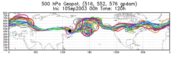
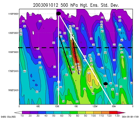
It can be seen that Maemi seems to influence an area (white lines) that stretches and broadens downstream with increasing forecast time. The two maxima in this area (black lines) are associated with the ET itself and a downstream system.
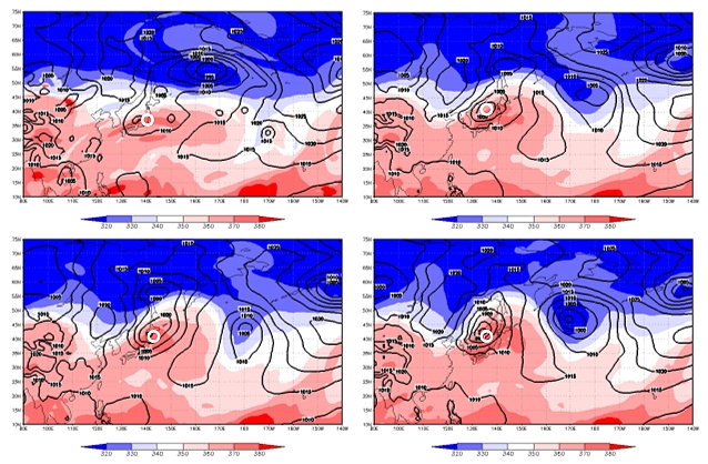
Our method of analysis that consists of a principal component analysis with clustering of the principal components shows that the ensemble members build natural groups with different atmospheric developments that leads to the high variability (Fig. 2). With the aid of the principal component analysis regions of strongest variability in terms of strength and location of the midlatitude trough-ridge pattern and the contribution of each ensemble member to this variability can be found. The clustering of principal components groups members together that contribute in a similar way to the variability patterns.
 |
|
Fig. 2: 4 selected clusters for the EPS forecast from 10 September 2003 12 UTC valid on 14 September 00 UTC. Shaded: Potential temperature on the dynamic tropopause. Contours: Surfacepressure. Maemi is marked by a white circle. |
Experiments
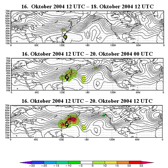
To generate an ensemble at the ECMWF in addition to the initial perturbations in the extratropics targeted initial perturbations are calculated for tropical cyclones. In the recent upgrade to the ECMWF EPS the calculation of these initial perturbations has been modified so that it is now applied to tropical cyclones as they move into the midlatitudes and undergo extratropical transition. In this project we design new experiments to investigate the impact of the new initial perturbations on the predictability of the extratropical transition and the downstream flow. We rerun the EPS for selected ET cases with and without targeted initial perturbations and determine the differences. The root-mean-square deviation of the ensemble members from the control forecast (RMSD) is used as a measure to assess the impact of the perturbations. In Fig. 3 the difference of the RMSD is compared for the runs from 16 October 2004 12 UTC with and without perturbations targeted on Typhoon Tokage (2004).
With the aid of the method of analysis explained before it can be shown that the higher variability in the runs with perturbations targeted on Tokage is associated with additional patterns of atmospheric development that could not be seen in the experiments without perturbations targeted on Tokage.
|
|
|
Fig. 3: Forecast from 16 October 2004 12 UTC. RMS difference of the EPS forecast with targeted perturbations on Tokage minus RMS difference of the EPS forecast without targeted perturbations on Tokage (shaded), geopotential on 200 hPa (contours).
|