Boundary Layer Dynamics

Overview:
The structure of the atmospheric boundary layer (ABL) depends mainly on the energy exchange at the Earth’s surface. However, due to the high natural and anthropogenic emissions in Southwest Africa, gaseous and aerosol air pollutants also affect the diurnal cycle of the ABL, as do sea breeze and monsoon flows from the Gulf of Guinea.
Characteristic features, for example nocturnal low-level jet (LLJs), deep daytime ABLs, and various types of boundary-layer clouds often occur and during the course of the day a transition from nocturnal low-level stratus to stratocumulus, congestus and cumulonimbus clouds is observed. The atmospheric processes driving this transition is sensitive to the conditions mentioned above and although the nocturnal low-level stratus and the transition to broken clouds appear quite frequently, little attention has been paid to the phenomenon so far.
In this work package, the intention is to identify the meteorological controls on the whole process chain from the formation of nocturnal stratus clouds, via the daytime transition to convective clouds and the formation of deep precipitating clouds. This will be achieved by performing detailed intensive in-situ and remote sensing observations in addition to highly resolved model simulations (large eddy simulations, LES). The intensive observational period will include measurements of the energy-balance components at the Earth’s surface, the mean and turbulent conditions in the nocturnal and daytime ABL as well as measurements of the de- and entrainment processes between the ABL and the free troposphere. The meteorological measurements will be supplemented by air chemical observations.
Science Activities:
Objectives
- prepare and plan the installation of surface-based instrumentation at two supersites in Ghana and Benin and an additional smaller measurement site at the OAU campus in Ile Ife
- deploy and run the instrumentation at the two supersites and the OAU campus for seven weeks centred on the aircraft intensive operation period
- provide a quality-controlled observational dataset
- analyse the observational data with respect to the diurnal evolution of the radiation and energy balance of the Earth’s surface, the growth and conditions of the nocturnal and daytime ABL, the formation and breakdown of nocturnal low-level jets, the formation, characteristics and dissolution of low stratus clouds, radiation and entrainment at cloud top and coupling to the land surface via soil moisture and vegetation
- set up LES sensitivity and realistic runs on ABL processes and low cloud formation and dissolution
- develop a conceptual model of ABL evolution and low-cloud formation
- contribute to the evaluation of coarser-resolution models used in other WPs.
Significant results and achievements
- High-resolution COSMO simulations reproduced the evolution of LLCs. The simulations gave hints for possible processes relevant for LLC formation.
- During the DACCIWA campaign, state-of-the-art in-situ and remote sensing instruments were successfully deployed at sites in Ghana, Benin and Nigeria.
- During the 7-weeks campaign, 15 IOPs were simultaneously performed at three supersites. The observations include the thermodynamic and dynamic structure of the boundary layer and of the free atmosphere (Monsoon layer, Harmattan layer, African Easterly jet).
- LLCs were surveyed nearly every night.
- The characteristics of the LLCs showed a significant day-to-day variability, i.e. onset, cloud base, depth and dissolution differed significantly.
- An LLJ developed almost every night - normally prior to the LLCs.
- The observation will allow investigating nocturnal drizzle from the LLCs.
- The evolution and structure of the cloud-topped CBL differed from day to day and likely depended on the nocturnal stratus and mid- and upper level clouds.
- On many days, convective precipitation occurred in the afternoon.
- Probably for the first time, eastward moving convective precipitating cells were measured in the investigation area.
Field Activities:
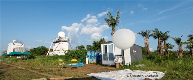
In June and July 2016, comprehensive measurements were successfully performed at the three DACCIWA-supersites at Savè (Benin), Kumasi (Ghana), and Ile-Ife (Nigeria). Besides near-surface observations, the boundary layer was scanned by various active and passive remote sensing systems as well as surveyed by radiosondes, tethered sondes and remotely piloted aircraft systems. The extensive data set allows to study the temporal and spatial characteristics of the low-level stratus, the breakup in the morning and the convective boundary layer as well as the relevant processes. The four institutes involved in this ground campaign are now in the stage of data quality control and process in order to make the dataset available to everyone in the DACCIWA database by the end of January 2017.

The tower for meteorological and air chemical measurements at Savè supersite.

Preparing the decision for an intensive observation period.

The remotely piloted aircraft system at Savè ready for the next boundary-layer flight.
Models:
This work program will take advantage of LES modelling
Project Lead:
Dr Norbert Kalthoff - norbert kalthoff ∂does-not-exist.kit edu
Karlsruhe Institute of Technology
76021 Karlsruhe
Germany
www.imk-tro.kit.edu/english/index.php
Other Partners:
- UPS
- KNUST
- OAU
- University of Leeds