
Analysis of the regional atmospheric water budget using COSMO-CLM model simulations and GPS observations
- Contact: Dr. R. Sasse, Dr. G. Schädler,Prof. Dr. Ch. Kottmeier
- Project Group: IMK-TRO
- Funding:
HGF
Short description:
The purpose of this study is to examine and validate the atmospheric water budget on the regional scale and its dependence on atmospheric conditions and topography using COSMO-CLM model simulations and GPS observations.
The Research Network EOS
This study is a contribution to the topic ‘Trends in the Atmospheric Water Cycle’ of the Helmholtz Research Network EOS (Earth Observing System). It was initiated in 2003 to link and develop the HGF (Helmholtz Association of German Research Centres) competences in the fields of geosciences and earth observation. The topic ‘Trends in the Atmospheric Water Cycle’ includes:
- Development, testing and application of new observation systems
- Diagnosis of processes within the atmospheric water cycle
- Quantification of the regional water cycle; trends of the atmospheric water content.
In the following the contribution of IMK-TRO is presented.
EOS Subproject: Analysis of the regional atmospheric water budget using COSMO-CLM model simulations and GPS observations
Motivation:
Already on the global scale, information about the atmospheric water budget components (precipitation, evapotranspiration, horizontal moisture transport) and their transfer rates vary. This scatter grows when changing to the regional scale due to the considerable variability of orography, soil characteristics, vegetation and atmospheric weather conditions involved. Up to now, not many regional water balances were calculated, especially on climatological time scales. In addition to the fundamental understanding, the quantification of the regional water budget becomes more and more important for water management considering climate change and associated modifications of the atmospheric water cycle.
 |
|
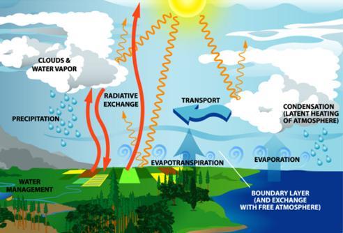
Fig. 1: Components of the atmospheric water cycle. |
Purpose:
The spatially and temporally highly resolved measurements of the integrated water vapour content using the Global Positioning System (GPS) and simulations with the regional climate model COSMO-CLM are combined to determine the water budget components for selected regions (dimensions ca. 103 - 105 km2). The following objectives are defined:
- Comparison of the observed and simulated water vapour changes, precipitation and evapotranspiration
- Improvement of the simulated precipitation and evapotranspiration by combining model simulations and GPS observations
- Analysis of the influence of atmospheric conditions and topography on the atmospheric water budget on climatological time scales
Methods:
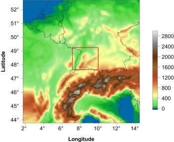
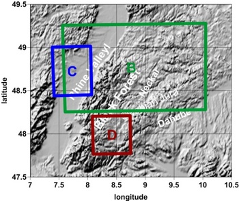
The water budget components are determined for so-called control volumes whose size and position can be chosen arbitrarily. The region of interest is Southwest Germany (Fig. 2, left). Since the validation of the model results is an essential part of this study, we use data from the COPS (Convective and Orographically-induced Precipitation Study) campaign. COPS took place in this region in summer 2007 and provided appropriate as well as large data sets of meteorological variables in high spatial and temporal resolution for water budget studies. For the comparison of observations and simulations control volume B was chosen (Fig. 2, right).
 |
|
|
|
Fig. 2: Left: Terrain heights based on the COSMO-CLM simulations and the investigation area (red). Right: Control volumes for various investigations of the atmospheric water budget (see text). |
||
The long-term analyses of the influence factors on the atmospheric water budget comprise the summer periods from 2005 to 2009. To study the impact of the synoptic situation, the daily water balances related to control volume B and the considered time period are classified based on the inflow direction of air masses
- Southwest (SW),
- Northwest (NW),
- Southeast (SE),
- Northeast (NE),
and on the cyclonality in 500 hPa
- anticyclonic circulation (XXA),
- cyclonic circulation (XXZ)
in case of non-defined inflows. The information about the inflow direction and the cyclonality are provided by the objective weather type classification (Bissolli and Dittmann 2001). The influence of the topography is analysed by comparing the atmospheric water budgets of the Rhine Valley (control volume C) and the low-mountainous region of the Black Forest and the Swabian Jura (control volume D; Fig. 2, right).
Results:
Model validation
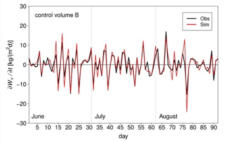
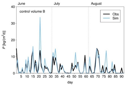
Comparisons between the observations and simulations of the daily water vapour change and the daily precipitation intensities are illustrated in Fig. 3 and Fig. 4 for the COPS period from 1 June to 31 August 2007. The results show good agreements between the temporal variations of the observed and simulated values. In general, the water vapour change as well as the precipitation is overestimated by the model. However, the comparison indicates good correlations. Hence, we conclude that the model simulations provide suitable results to study the atmospheric water budget and its influences.
 |
|
Fig. 3: Daily water vapour change rates from 1 June to 31 August 2007 for control volume B. Black: observations, red: simulations. |
 |
|
Fig. 4: Daily precipitation rates from 1 June to 31 August 2007 for control volume B. Black: observations, blue: simulations. |
Influence of weather conditions on the atmospheric water budget:
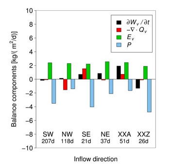
To learn if the atmospheric water budget is characteristic for each of the six defined weather conditions, the mean contributions of the water budget components are calculated (see Fig. 5). In general, the classes SW, SE and XXZ are connected to higher mean precipitation intensities than the classes NW, NE and XXA. At the same time high precipitation goes along with low evapotranspiration. Water vapour transforming to precipitation water mainly gets into the control volume via horizontal moisture transport. Consequently, convergence, which implies an increase of water vapour due to horizontal transport, is an important factor driving precipitation.
 |
|
Fig. 5: Mean contributions in kg/(m2d) of the atmospheric water budget components for each meteorological condition. Black: total water vapour change, red: water vapour convergence, green: evapotranspiration, blue: precipitation. |
The partitioning of the atmospheric water budget can be lead back to the inflow direction, the air mass characteristics (humidity, temperature), and the impact of high and low pressure systems. This helps us to establish statistical significant quantifications of the atmospheric water budget under various meteorological conditions. Therefore, long-term studies on the change of the atmospheric water budget in the context of climate change necessarily have to consider information about a varying occurrence and frequency of weather patterns.
Influence of topography on the atmospheric water budget:
The topography clearly influences the atmospheric water budget as it can be seen in Fig. 6. The maximum precipitation and evapotranspiration intensities are noticeable at the western slope of the Black Forest. Since the main inflow direction during the considered time period is from Southwest this region corresponds to the windward side. Horizontally transported air masses are lifted to overflow the mountain ridges. Consequently, water vapour condenses and precipitation occurs. In addition, orographically-structured terrain is well-known for small-scale thermally-induced wind systems which also initiate convective processes, cloud formation and precipitation.
|
|
|
|
Fig. 6: Mean spatial distribution of the precipitation (left) and the evapotranspiration (right) in kg/(m2d) for the summer months from 2005 to 2009. In addition, the position of the control volumes C (blue; Rhine Valley) and D (red; Black Forest/Swabian Jura) are marked. |
|
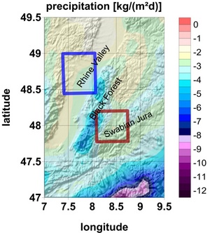
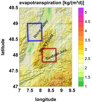
The enhancement of the evapotranspiration in the low-mountainous region mainly is connected to the higher afforestation of the Black Forest and the Swabian Jura compared to the Rhine Valley. The transpiration from plants has a large contribution to the total evapotranspiration. Other factors driving evapotranspiration are, for example, a stronger heating of the land surface and higher wind velocities.
The results of our analyses indicate that the atmospheric water cycle intensifies in low-mountain regions. This corresponds to a higher transfer rate of water via convergence, precipitation and evapotranspiration. This intensification is also noticeable when separating the different meteorological conditions.
Cooperations:
GeoForschungsZentrum Potsdam, Departement 1: Geodäsie und Fernerkundung, Sektion 1.1: GPS/GALILEO-Technologien
Publications:
Sasse, R., Schädler, G. and Kottmeier, Ch. (2012): The Regional Atmospheric Water Budget over South-western Germany under Different Synoptic Conditions. J. Hydrometeor., 14, 69-84, Abstract