
Short description:
Sub-project of the project cluster: “A Bundle of proposals to exploit the data of the Convective and Orographically-induced Precipitation Study (COPS)” within the framework of the DFG Priority Program „Quantitative Precipitation Forecast (QPF)“. Within this project, a strategy to study the effects of soil moisture (SM), evapotranspiration and water vapour in the planetary boundary layer (PBL) on QPF will be applied on different scales (local to regional).
Scientific questions:
- Identification of the dependence of convection initiation (CI) on the spatial and temporal SM variability.
- Development of upscaling algorithms for soil moisture data from point measurements to the COSMO-grid.
- Investigation of the impact of the novel observed soil moisture and soil temperature data fields on convective precipitation modelling.
- Assessment of the required size and resolution of SM station arrays for future operational measurement networks.
Key words: soil moisture, convection, COSMO model, COPS
Aims
The distribution of water vapour in the atmosphere and its development over time is one of the most important factors in connection with precipitation processes. The availability of moisture for precipitation is controlled by a number of processes including (i) large-scale advection, (ii) moisture advection on the mesoscale exhibiting a daily cycle, and (iii) processes connected to the energy balance at the surface. The latter processes are strongly influenced by spatially variable fields of SM, vegetation and evapotranspiration. Moreover, spatial variations of SM can trigger convection, both on the local scale concerning the initiation of thermally induced wind regimes and on the mesoscale in connection with the initiation of convective systems. Therefore, an improved representation of SM fields in mesoscale model systems can be expected to produce better agreement between modelled and measured surface energy fluxes, boundary layer structure and precipitation.
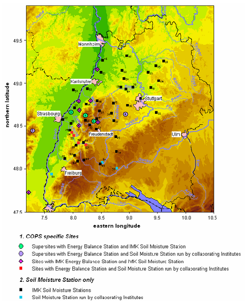
The main goal of this project is to study the effects of SM and water vapour in the PBL on QPF. Our aim is to identify the dependence of convectively and orographically induced precipitation on the variability of the SM field and the corresponding processes in the PBL. This is made possible by a unique data set realised during the COPS campaign using a very high number of SM sensors on various scales (Fig. 1). This work constitutes a central part of the overall COPS strategy by thorough analyses of the measurements data and aims to improve the QPF by better process representation in the weather prediction model COSMO.
 |
|
Figure 1: COPS domain. |
Methodology:
At first, the identification of the temporal and spatial scales on which soil moisture variability affects convective precipitation will be performed by using the high-resolution data set gained at the COPS field campaign. The required size and resolution of SM station arrays for future operational measurement networks will be established.
Optimized soil moisture fields will be compared to their related representation within COSMO and the global model GME. COSMO model runs at 7 km resolution will be initiated with the optimised fields to study the impact of surface on convective precipitation. The model sensitivity to soil type, orography, and land use will be investigated.
Results:
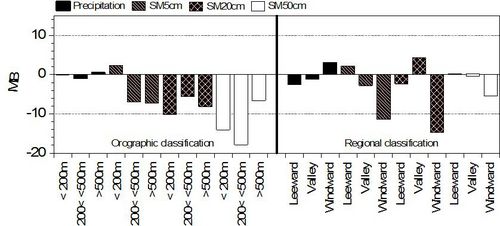
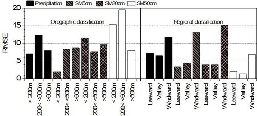
Initially, the CCLM simulations of the process chain of soil moisture, surface fluxes, conditions of the convective boundary layer (CBL), and convection-related parameters leading to convective precipitation was validated using measurements and the soil moisture network deployed during the COPS campaign, the latter covered an area of about 180 by 180 square kilometres in south-west Germany and eastern France which includes regions with different characteristics. Two distinct classifications were applied for comparisons: i) regional classification and ii) orographic classification. The results showed that the 7 km horizontal resolution used for the CCLM model simulations was not high enough to capture the strong spatial variability of the soil moisture. When point by point comparisons were made between soil moisture station measurements and the nearest grid point in the model a large difference was found for all levels investigated (Fig. 2). The agreement improved when areal means were used. This validation exercise pointed out important model deficiencies such as errors in the soil type inventory and the initialisation of the deeper soil layers. The sensitivity of the model to initialization values was investigated. This experiment showed that soil moisture initialization values significantly impact the precipitation amount and distribution, however, the relationship between soil moisture and precipitation variation was not clear. COPS observations were used to initialize the model. The COPS soil moisture measurements were interpolated to the grid size of the model for the area covered. The surface height field was modified in accordance. No real improvement could be found after initialization. Probably, the reason was the small amount of soil moisture stations available for the initialization, which covered a very small portion of the model simulation domain and the lack of soil moisture measurements at deeper layers than the 50 cm depth.
|
a)
|
|
|
b)
|
|
|
Figure 2: a) Calculated bias and b) RMSE of daily averages of randomly chosen individual sites (within each classification group introduced) of observed and simulated soil water content in Vol. % at depths of 5, 20 and 50 cm for the observations and 6, 18 and 54 cm for the simulations, and precipitation in mm/day for summer 2007. |
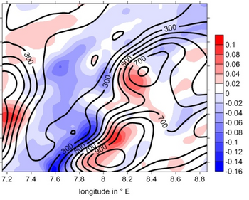
The impact of the land surface scheme used on the simulation of the surface-atmosphere feedback processes was studied using the standard TERRA-ML and the VEG3D SVAT models. Considerable differences between the simulations were found out (Fig. 3) which is being investigated at the present time.
 |
|
Figure 3: CCLM simulations of average hourly precipitation for the area of the Black Forest and the Rhine valley for the month of July: difference between the TERRA and the VEG3D SVAT models. |
Future experiments with a horizontal resolution of 2.8 km will be performed to investigate the sensitivity of the simulated soil moisture and precipitation fields to the resolution of the model. The simulation period will be extended to at least 5 years to investigate the soil moisture and precipitation feedback processes for longer time scales. Because no correlation between the local soil moisture and precipitation was found out, upstream soil moisture conditions will be modified to investigate the impact on precipitation within the COPS domain.