
KLIWA - Soil erosion due to precipitation in the context of climate change
- Contact:
Dr. G. Fosser, Dr. G. Schädler
- Project Group:
IMK-TRO
- Funding:
LUBW
- Partner:
Geomer, Bodengut, Süddeutsches Klimabüro
Short description:
The KLIWA project ”Bodenabtrag durch Wassererosion in Folge von Klimaveränderungen“ (soil erosion due to precipitation in the context of climate change) is based on the collaboration between IMK-TRO, Geomer and BodenGut. The purpose is to assess the impact of climate change on soil erosion.
Motivation:
Recent research predicts for the near future an increase in precipitation in winter coupled with a slight decrease and more variability in summer in Central Europe. Despite high regional variability, studies indicate that there will be a raise in the frequency and intensity of summer extreme precipitation events. Such increased heavy summer rainfall on wet and dry soil is likely to lead to the enhancement of the erosion risk.
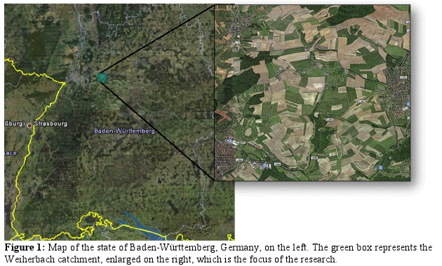
Soil erosion usually acts on a very small spatial and temporal scale. Figure 1 shows the Weiherbach catchment, in southwest Germany, one of the erosion prone areas selected within the project. This catchment is only circa 6 km2 large, which implies the need for very high spatial and temporal resolution precipitation data and statistics.
Method:
Global climate projections for the recent past (ca. 1961-2008) and near future (2011-2050) will be downscaled with the regional model COSMO-CLM up to 1 km resolution for selected locations with high erosion risk in Baden-Württemberg, Rhineland-Palatinate and Bavaria. The project partners will use these data as input for the erosion model LISEM. In addition, it will be investigated:
• the advantage of higher spatial and temporal resolution in comparison to 7 km resolution
• if the direct simulation of convective precipitation improves the results
• which changes in erosion-related extreme precipitation events are there to be expected in the future
Results:
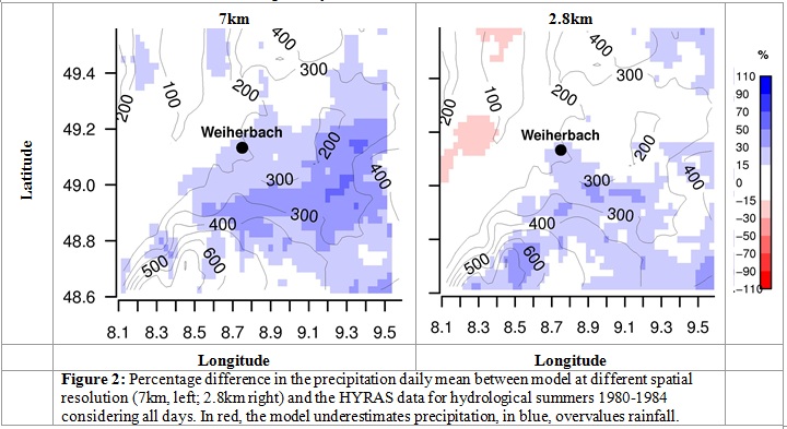
After having selected the optimal model setup and domain size and location, we investigated the advantage of higher spatial resolution in comparison with 7km resolution. The simulations were run using ERA40 reanalysis data in order to validate the model outputs with observational data. Figure 2 shows the differences in precipitation daily mean between model outputs at different resolution (7km, on the left; 2.8km, on the right) and the HYRAS dataset calculated for hydrological summers 1980-1984 considering all days.
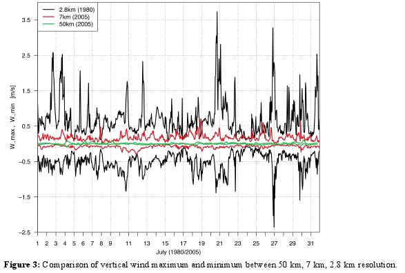
Another advantage of very high resolution is a more accurate representation of orography, which leads to stronger vertical wind. Figure 3 shows the differences in of vertical wind maximum and minimum between 50 km, 7 km, 2.8 km resolution for July 1980. At coarser resolution the maxima are never above 0.5 m/s, while at 2.8 km resolution it reaches picks of over 3.5 m/s. This is crucial also for a better representation of precipitation since convergence is one of the triggering mechanisms for convection. The 2.8km resolution seems also being able to better represent the daily cycle of precipitation.
Next steps:
1. A more detailed analysis of the benefit of higher spatial resolution in comparison to 7 km resolution in the representation of the atmospheric fields.
2. Simulation of extreme events at high resolution in the recent past (1971-2000) as well as in the near future (2011-2050) with ECHAM 5 both at 2.8 km and 1 km resolution; statistical comparison between the past and future results and identification of changes in frequency and intensity.
3. Analysis of the results with statistical methods, assessment of uncertainties.
Related Publications:
Panitz, H.-J., Fosser, G., Sasse, R., Sehlinger, A., Feldmann, H. and Schädler, G. (2012): Modelling Near Future Regional Climate Change for Germany and Africa. Submitted to High Performance Computing in Science and Engineering.
Conferences:
Fosser, G., Berg,P., Khodayar , S., Schädler, G. (2012): Cloud-resolving scale: the challenges and the added value. EMS Annual Meeting, 10.-14.09.2012.