
Mapping the complex rainfall seasonality of the Greater Horn of Africa
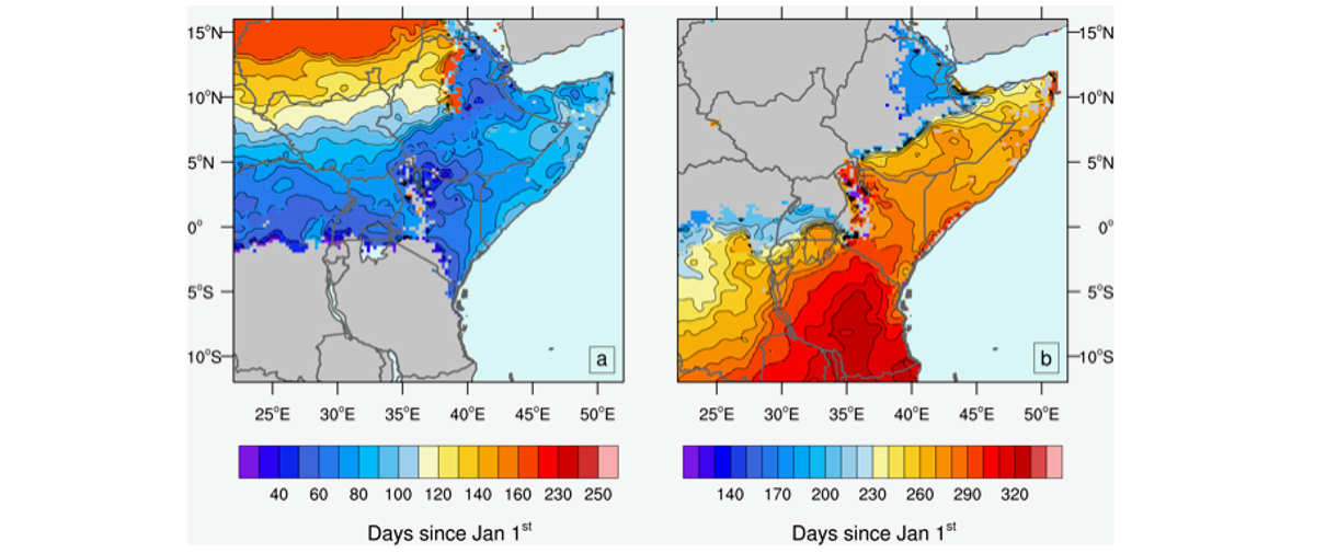
The Greater Horn of Africa (GHA) region encompasses a large part of tropical East Africa and includes the countries Sudan, South-Sudan, Somalia, Eritrea, Djibouti, Ethiopia, Kenia, Uganda, Tanzania, Ruanda, and Burundi. The rainfall climatology of this region is one of the most challenging in the tropics, given its strong seasonal cycle and up to three rainy seasons in some areas. This complexity arises from the heterogeneous topography, the influences of the East African Lakes and Indian Ocean, as well as from large-scale remote phenomena like El Niño. Previous studies on observed or projected rainfall trends for the GHA generally focus on calendric 3-month periods (e.g. March to May, October to December), and thus partly neglect the complexity of the rainfall seasonality. In Seregina et al. (2018), a novel and flexible methodology was introduced to characterise more adequately the rainfall seasonality for GHA. Assessed are the onset, cessation and duration of the rainy seasons, as well as the associated uncertainties from measurements. The method is applied to the Climate Hazards Group InfraRed Precipitation with Stations (CHIRPS) satellite product and to an extensive rain gauge data set. For most of the study area, a strong agreement with the commonly used calendric rainy seasons is found. However, considerable deviations are identified for several rainy seasons and areas, which can exceed 30 days (cf. Figure). The specific regional atmospheric characteristics can strongly influence the start and end dates of rainy seasons, a fact that is disregarded by calendric definitions. Compared to the calendric definition, a clear added value is found for the new approach, as it can capture the local rainfall features, for example associated with the sea breeze circulation. In turn, this enables evaluations across rainfall seasonality borders. Thus, the more precise definition of the rainy season permits a consistent assessment of rainfall characteristics, like intensity and rainfall amounts, trends or temporal shifts of rainy seasons. This novel method can also potentially provide a more adequate calibration of climate model simulations thus potentially enabling more realistic climate change projections for the GHA, thus facilitating climate impact studies and the development of climate services for the region.
The NCL program code is available online and can be applied to other tropical regions.
| Figure: Examples for the timing of the rainy seasons of the Greater Horn of Africa. (Left) average onset date during the northward progression, and (right) during southward progression in days since January 1st, estimated from the satellite product CHIRPS. |
Reference: Seregina LS, Fink AH, van der Linden R, Elagib NA, Pinto JG (2018) A new and flexible rainy season definition: validation for the Greater Horn of Africa and application on rainfall trends. Int J Climatol doi:10.1002/joc.5856
The code for the calculations is available at: https://github.com/GHA-rainy-seasons2018/GHA_rainy_season_definition
[Working groups: "Regional Climate and Weather Hazards" and "Atmospheric Dynamics"]