
Stratospheric impact on cold spell predictability: The 2018 case
In mid-February 2018, there was a change in the direction of the dominant stratospheric polar night jet from westerly to easterly. Such an event is called sudden stratospheric warming (SSW), as it is associated with a rapid temperature increase in the stratosphere (the atmospheric layer between 12 and 50 km). SSWs are rare but very relevant for the variability of the Northern Hemisphere wintertime circulation. Moreover, the stratospheric state can influence surface weather e.g. in favoring the occurrence of weather extremes. During late February/early March 2018, a severe cold spell with surface temperatures reaching 10° below its climatology hit Eurasia. This cold spell was associated with a persistent weather pattern over Scandinavia (known as Scandinavian blocking) followed by an extreme negative phase of the North Atlantic Oscillation (NAO) associated with anomalously lower surface pressure over the Azores and higher surface pressure over Iceland.
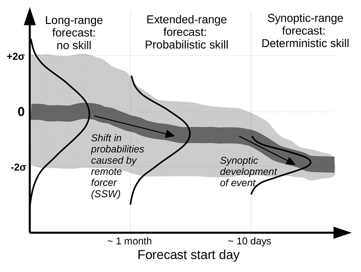
We investigated the predictability of this cold spell/NAO event using ensemble forecasts from the Subseasonal-to-Seasonal (S2S) archive of the European Centre for Medium-Range Weather Forecasts (ECMWF). Ensemble forecasts cover a number of possible forecast scenarios, called ensemble members, which are calculated with slightly different initial conditions to estimate the range of possible evolutions of the weather conditions for the following days and weeks. It was found that this event was predicted with the observed strength roughly 10 days in advance. However, the probability of the cold spell occurring doubled already 25 days in advance, when the SSW occurred (cf. Fig. 1). The amplitude of the cold spell was increased by a regime shift to the negative NAO phase at the end of February, which was likely favored by the SSW. We quantified the contribution of the SSW to the enhanced extended-range forecast skill for this particular event by running additional forecast ensembles in which the evolution of the stratosphere was nudged to (a) the observed evolution, and (b) the climatological state. Here, nudging means that the forecasts are running freely in the troposphere but with prescribed stratospheric evolution. In experiment (a), the probability of a strong cold spell occurring was increased by 45%, while it was at its climatological value of 5% when the stratosphere was nudged to the climatological state (experiment (b)). This case study is novel as most of the previous studies have focused on the average characteristics of many single events (composites) to investigate the link between surface extremes, SSWs and its effect on predictability. However, we caution that probabilistic gain in predictability alone is insufficient to conclude a causal link between the SSW and the cold spell
| Fig. 1: Schematic showing the predictability of a surface extreme event for different forecast ranges (long-range forecasts with lead times of 1 month to synoptic-range forecasts with lead times of only a few days) under the influence of remote forcing (e.g. sudden stratospheric warming, SSW) occurring during the extended range. Light grey shading indicates the ensemble spread (5th to 95th percentile), while dark grey shading indicated the ensemble mean. |
For more details please see Kautz et al. (2020) [1]. This study is conducted within the C8 project (https://www.wavestoweather.de/research_areas/phase2/c8/index.html) of the Transregional Collaborative Research Center “Waves to Weather” (CRC/Transregio 165; W2W) and in collaboration with the ECMWF.
[1] Kautz*, L-A, Polichtchouk*, I, Birner, T, Garny, H, & Pinto, JG. Enhanced extended‐range predictability of the 2018 late‐winter Eurasian cold spell due to the stratosphere. QJR Meteorol Soc. 2020; 1-16. https://doi.org/10.1002/qj.3724
Working group: Regional Climate and Weather Hazards