
Evaluation of the urban climate model PALM-4U over Stuttgart
Due to high population density and modifications of atmospheric processes caused by urban structures and complex terrain, there is a high need for a building-resolving atmospheric model that enables numerical simulations of atmospheric processes in urban areas. Such a model is the new urban climate model PALM-4U [1]. Its further development, evaluation and optimisation is the aim of the second phase of the research programme Urban Climate Under Change [2].
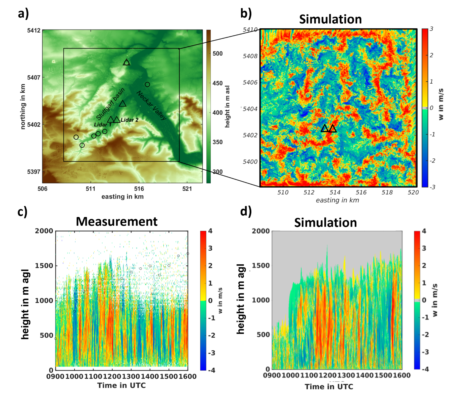
At IMK we work on the evaluation of the PALM-4U model applied to the atmospheric boundary layer (ABL) over cities in mountainous terrain. Our aim is to simulate the ABL under such conditions, compare the simulation results such as wind, temperature, turbulence with the observations in order to evaluate the PALM-4U model. The measurements needed for the model evaluation took place in the city of Stuttgart and its surroundings in the years 2017 and 2018 and were carried out by two Doppler lidars of type Leosphere Windcube WLS8 (Lidar 1) und HALO Photonics (Lidar 2) as well as one scanning micro-wave radiometer of type HATPRO. Doppler Lidars were used to measure vertical profiles of three-dimensional wind components; the micro-wave radiometer to derive vertical profiles of temperature and humidity.
One focus is on the simulation of the convective boundary layer (CBL), i.e. its vertical structure and temporal evolution. In order to characterise the CBL, the turbulent processes must be recorded. The corresponding turbulence parameters can be obtained by vertical wind measurements and simulations alike.
The PALM-4U simulations were performed for a clear-sky summer day, 20 June 2018. Topography and land-use information was provided by DLR (German Aerospace Center); the initial state of the atmosphere was generated from COSMO-D2 model data (German Meteorological Service, DWD). The model domain had a size of 12 km x 12 km x 2.4 km in x-, y-and z-directions, respectively and included the Stuttgart basin and a part of Neckar Valley (Fig 1a). Grid spacing was 10 m in each direction. Figure 1b shows a horizontal cross-section for the instantaneous vertical wind at a height of 500 m at 12 UTC. Figure 1c shows the vertical wind measurement from Lidar 2. Figure 1d shows the PALM-4U-output of the vertical wind at the location of Lidar 2. The next step is to obtain the turbulence parameters from the simulation results as well as from the measurements and compare them. The validation of the simulated horizontal wind field by virtual tower measurements [3] is in preparation, too.
Lidar 2
References:
[1] Maronga B., et al., (2020). Overview of the PALM model system 6.0. Geoscientific Model Development 13, https://doi.org/10.5194/gmd-13-1335-2020
[2] Scherer, D.; Antretter, F., Bender, S.; Cortekar, J.; Emeis, S.; Fehrenbach, U.; Gross, G.; Halbig, G.; Hasse, J.; Maronga, B; Raasch, S; Scherber, K. (2019). Urban Climate Under Change [UC]2 – A National Research Programme for Developing a Building-Resolving Atmospheric Model for Entire City Regions. Meteorologische Zeitschrift, https://doi.org/10.1127/metz/2019/0913
[3] Wittkamp, N.; Adler, B.; Kalthoff, N.; Kiseleva, O. (2021). Mesoscale wind patterns over the complex urban terrain around Stuttgart investigated with dual-Doppler lidar profiles. Meteorologische Zeitschrift, 30 (2), 185–200. https://doi.org/10.1127/metz/2020/1029
17.6.2022
Olga Kiseleva, Leonhard Gantner, Working group: “Boundary Layer und convective systems“. LINK: https://www.imk-tro.kit.edu/english/782.php