
05/07/2023 - Machine learning-based weather forecasts now available at kit-weather.de
For more than six decades, weather predictions based on numerical models solving physical equations have continuously improved and thus provided increasingly better information for day-to-day decision making. This "quiet revolution"[1] can be attributed to, among other things, a better observing system, better data assimilation, a better representation of physical processes in the model, and continuously growing computing resources. In the last three years, a paradigm shift has taken place, culminating in the last 12 months: Instead of research institutions and weather services, large technology companies such as Google, NVIDIA, Microsoft, and Huawei have developed weather prediction systems based on machine learning algorithms trained with decades of meteorological data. The astonishing thing is that these models achieve for some, especially larger-scale, meteorological fields a forecast quality that is similar or even higher than that of numerical weather prediction models run by the world's leading forecasting centers but at computing costs that are several orders of magnitude smaller
For IMK’s own website kit-weather.de, we now provide 7-day forecasts using the Pangu-Weather algorithm developed by Huawei [2]. This model was trained with so-called reanalysis data from the past 40 years provided by the European Centre for Medium-Range Weather Forecasts. Taking the operational analysis of the German Weather Service (DWD) as initial conditions, it now allows us to generate cost-effective and energy-saving forecasts. On the high-performance computers of KIT’s Steinbuch Centre for Computing, a global 7-day forecast using Pangu-Weather consumes 14 Watt-hours (a medium-sized electric car consumes this energy on 90 m of driving). In contrast, the energy consumption for a forecast with a state-of-the-art numerical weather prediction model would amount to 30,000 Watt-hours (an electric car consumes this energy on 200 km of driving). This estimate, however, does not take into account the energy needed to generate the training data, nor does it include the energy needed for the training itself. Still the development of purely data-driven weather forecasting systems is another revolution but faster and maybe less quiet than the first. It opens up many exciting research avenues, which will be explored in future projects at the IMK-TRO such as TEEMLEAP (A new TEstbed for Exploring Machine LEarning in Atmospheric Prediction) and the ERC-funded project ASPIRE (Advancing Sub-seasonal PredIctions at Reduced computational Effort).\JQ
[1] Bauer, P., Thorpe, A. & Brunet, G. The quiet revolution of numerical weather prediction. Nature 525, 47–55 (2015). https://doi.org/10.1038/nature14956
[2] Bi, K., Xie, L., Zhang, H., Chen, X., Gu, X., Tian, Q. Pangu-Weather: A 3D High-Resolution Model for Fast and Accurate Global Weather Forecast. (2022). https://arxiv.org/abs/2211.02556
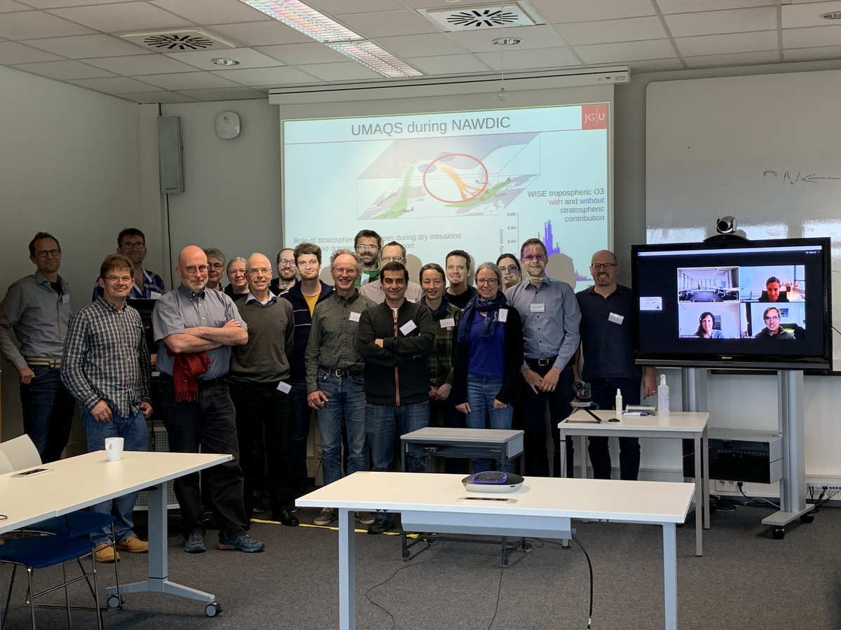
20/06/2023 - NAWDIC-HALO workshop at IMKTRO
The North Atlantic Waveguide, Dry Intrusion and Downstream Impact Campaign (NAWDIC) is an international effort for an airborne field campaign focusing on atmospheric dynamics. Its overarching aim is to advance our understanding of the synoptic- to micro-scale dynamical and physical processes associated with the triggering of severe wind gusts, heavy precipitation, and cold air outbreaks in the North Atlantic, Euro-Mediterranean region and of their representation in numerical weather prediction models. Lead by a team from IMK-TRO at KIT, and supported by Waves to Weather, NAWDIC is scheduled to take place in winter 2025/2026.
To advance the preparation of the deployment of the German “High Altitude and long Range Aircraft” (HALO) during NAWDIC and to foster the NAWDIC-HALO community, instrument scientists as well as atmospheric scientists from 7 research institutes gathered for a one day workshop at IMK-TRO. Talks on the planning status of NAWDIC helped to update everybody about the aims of the campaign. Talks dedicated to instruments onboard HALO provided valuable information for the design of flight strategies. Key outcome of the workshop is that we now formed a community around the NAWDIC-HALO component consisting of scientists from various institutions and universities in Germany and beyond. Furthermore, we and agreed on the instrumentation for NAWDIC-HALO and the design of the roadmap towards the actual campaign implementation. A next major step till be the international coordination of further NAWDIC components which will be part of a follow-up workshop at the European Centre for Medium-Range Weather Forecasts (ECMWF) in Reading on 30 June 2023.
14/02/2023 - Using weather regimes to better predict Dunkelflauten in Germany?

In December 2022, Germany experienced a period of calm, cloudy and extremely cold conditions for multiple consecutive days (December 10th to 18th, we further elaborate on this period at the end of the article). In a future scenario, with an increased share of solar and wind in the power system and an increase in the electricity demand due to electrification, the power system becomes increasingly sensitive to meteorological conditions like those in December 2022.
Periods of calm and cloudy conditions for multiple consecutive days are called Dunkelflauten (from the German word for dark wind lulls). The particular case of a Dunkelflaute in combination with colder than normal conditions is called a cold Dunkelflaute.
Predicting Dunkelflauten events well ahead of time is becoming more and more important for grid operators to prepare for potential shortages in supply and to plan a resilient energy system.
The variability of the large-scale atmospheric circulation in the North Atlantic-European region can be described by weather regimes (Grams et al., 2017). At the same time weather regimes modulate surface weather conditions (e.g., wind speed, temperature, solar irradiation) over country-size regions, e.g., Germany and multi-day periods. Therefore, weather regimes are particularly useful for sub-seasonal weather forecasts for the next 10-30 days. Understanding a potential link between weather regimes and Dunkelflauten might help anticipating Dunkelflauten events several weeks in advance.
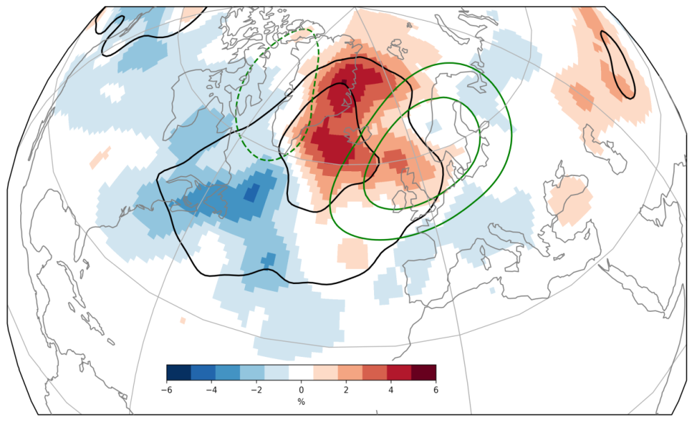
Our weather regime definition distinguishes four types of blocked regimes, characterised by high-pressure situations, and three types of cyclonic regimes, characterised by low-pressure situations in the North Atlantic-European region (Grams et al. 2017). In a recent study (Mockert et al. 2022), we found that Dunkelflauten in Germany mainly occur in winter, when the solar power output is low, and the wind power output drops for several consecutive days (bars in Figure 1). Also most Dunkelflauten can be linked to three out of the four blocked weather regimes (European, Scandinavian and Greenland Blocking; colors in Figure 1). They last from two days (by definition) up to eight days and occur on average two times per winter season. The Dunkelflauten occur in a well-established weather regime and in regime life cycles which persist longer than usual. Greenland Blocking Dunkelflauten are associated with colder conditions than usual, therefore considered as cold Dunkelflauten which are likely most critical to the energy system.
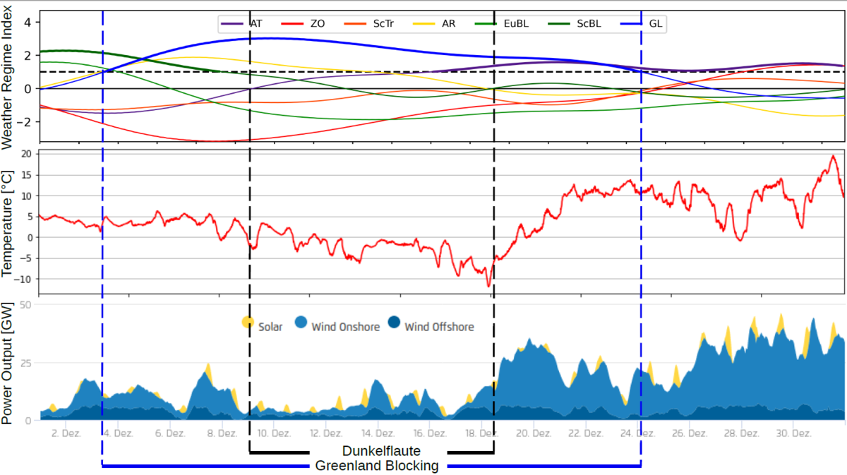
One example of a cold Greenland Blocking Dunkelflaute is the already mentioned cold Dunkelflaute in December 2022. The temperature in Karlsruhe (Figure 2 middle) dropped from 5°C at the beginning of December to a minimum of -12°C on December 18th. This cold period is related to a Greenland Blocking weather regime (Figure 2, top), which has been active from December 3rd to 24th. Alongside decreasing temperatures in Karlsruhe (or, generally speaking, Germany), the power supply by renewable energy sources (wind and solar) in Germany was particularly low from December 9th to 18th (Figure 2, bottom) and thus in the middle of the Greenland Blocking regime life cycle.
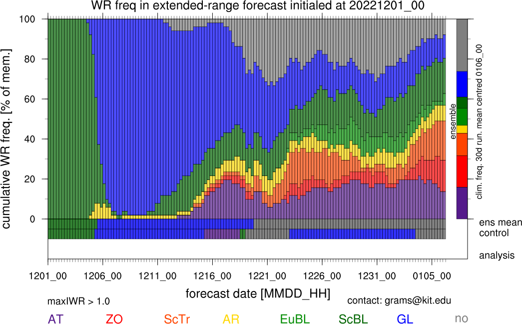
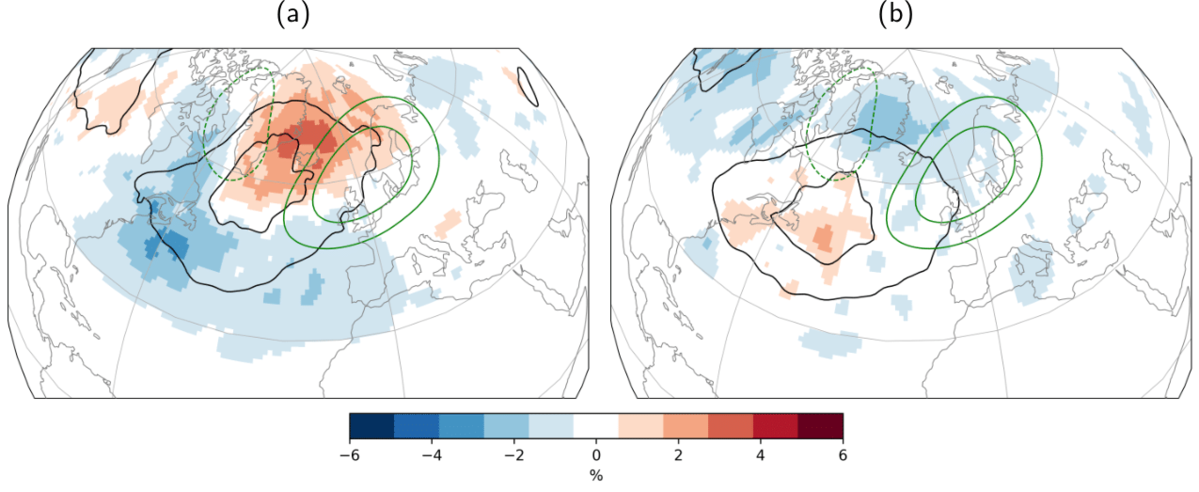
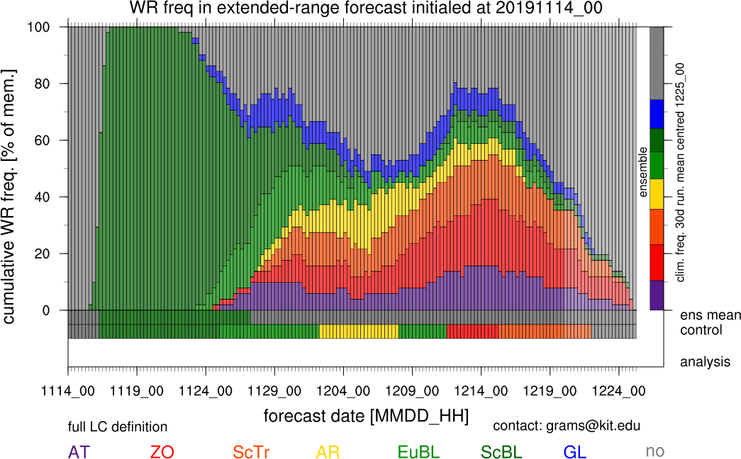
Analysing the extended-range weather regime forecast from December 1st (Figure 3), it becomes clear that the Greenland Blocking was well predicted. Thus, the forecast of the particularly long-lasting Greenland blocking episode would have been an effective indicator for the upcoming cold Dunkelflaute.
Figure Captions:
Figure 1: Monthly distribution of Dunkelflauten with the dominant weather regimes of Dunkelflauten indicated by the colour of the bars. The amount of Dunkelflauten is measured on an absolute scale for the 40 year period from 1979–2018.
Figure 2: Analysis of conditions in December 2022. Top: Weather regime index throughout December with an active Greenland Blocking regime (source: working group Large-scale Dynamics and Predictability) Middle: 2m Temperature at KIT Campus North 200m-Tower (source: IMK-TRO, KIT). Bottom: Power output by solar, wind onshore and wind offshore (source: https://www.agora-energiewende.de/service/agorameter)
Figure 3: Extended-range weather regime forecast initialised at December 1st 2022. A transition from the European Blocking regime, active at initialisation, to the Greenland Blocking regime is predicted for the beginning of December. Up to a lead time of 10 days, nearly all ensemble members agree on the dominant weather regime. The Greenland Blocking is predicted by the majority of ensemble members up to a lead time of 20 days. This period includes the cold Dunkelflaute prior to Christmas day.
References:
Christian M. Grams, Remo Beerli, Stefan Pfenninger, Iain Staffell, and Heini Wernli. Balancing Europe’s wind-power output through spatial deployment informed by weather regimes. Nature Climate Change, 7:557–562, 8 2017. ISSN 17586798. doi:10.1038/NCLIMATE3338.
Fabian Mockert, Christian M. Grams, Tom Brown, Fabian Neumann. Meteorological conditions during Dunkelflauten in Germany: Characteristics, the role of weather regimes and impacts on demand. ArXiv, doi: https://arxiv.org/abs/2212.04870v1.
\ FM
03/02/2023 - LSDP@KIT at the Annual Meeting of the American Meteorological Society
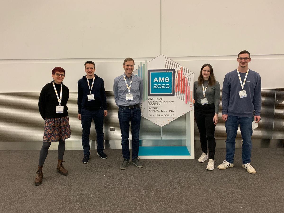
The American Meteorological Society (AMS) Conference is the premier event for meteorologists and weather enthusiasts. Recently, several members of the LSDP group had the opportunity to attend the 103rd AMS conference in Denver and learn from leading experts in the field. The conference featured a variety of presentations, panel discussions, and hands-on workshops that covered the latest research and developments in meteorology. We also presented our latest results and projects, including the overview of the Spreadout project (Christian Grams), the dynamics of Greenland Blocking regime lifecycle (Seraphine Hauser), the GulfImpact project (Marta Wenta), connection between MJO and WCBs (Julian Quinting) and WCBs influence on forecasts errors (Moritz Pickl). The conference gave us an opportunity to hear from researchers about new technologies and techniques for studying weather, as well as learn about the latest developments. AMS annual meeting also provided an opportunity for us to network with professionals in the field and learn about potential career opportunities. At this point we want to thank the University of Wisconsin-Madison for inviting us to their reception! Overall, the group found the conference to be an incredibly valuable and educational experience and we were happy to catch up with our US colleagues.
After the annual meeting of the AMS ended on Thursday, January 12th, all team members who attended the conference travelled to nearby Boulder to visit colleagues at the National Center for Atmospheric Research (NCAR). While Marta, Seraphine and Christian stayed for one extra day, Julian and Moritz extended their stay for 6 and 14 days, respectively. The group was mainly hosted by Judith Berner, who is an expert in model errors and stochastic representations of model uncertainties. We had fruitful and inspiring discussions with her on various projects, for example about how forecast spread and error grow in regions of WCB activity with different model uncertainty representations and in different models, and about a process-level understanding of stochastic model perturbations. On Friday, January 20th, Moritz gave a seminar talk in the Mesoscale and Microscale Meteorology (MMM) Happy Hour Seminar Series. We would like to extend a special thank you to Judith Berner, who graciously hosted our group during the visit. Apart from our scientific discussions, Judith made sure that we had everything we needed to make the most of our time at NCAR.\MW\MP
25/11/2022 Julian Quinting wins an ERC Starting Grant – Congratulations!

LSDP Team member Dr. Julian Quinting has successfully applied for a starting grant by the European Research Council (ERC). His new project Advancing Subseasonal Predictions at Reduced computational Effort (ASPIRE) aims to improve weather forecasts at reduced computational costs to save computing time and energy. Thereby Julian will focus on leveraging potential predictability in the Tropics for subseasonal weather forecasts in the Midlatitudes. By improving predictions in the Tropics through higher resolution and machine learning ASPIRE aims to constrain a potential source of error and to improve the teleconnection toward the Midlatitudes.
Julian was one of the first members of the LSDP team and (re)joined KIT in February 2018. He engaged in many of the team’s research activities, in particular in the implementation of our ML-based WCB diagnostic ELIAS2.0. He supervised various Master theses and supported the team in programming and data issues. With the ERC starting grant Julian will found his own research group but we will closely keep in touch and collaborate with his new team. We are at the same time sad that Julian will leave the LSDP team and also very very happy for Julian about his well-deserved recognition. Congratulations Julian! \ CG
Please also visit the official KIT press release here: https://www.kit.edu/kit/english/pi_2022_104_climate-research-making-weather-forecasts-more-precise-and-more-efficient.php
17/11/2022 - 6th WGNE Workshop at ECMWF
Christian and Julian attended the “6th WMO/WCRP Working Group on Numerical Experimentation (WGNE) workshop on systematic errors in weather and climate models” from 31 October to 4 November. After more than two years of online conferences, this workshop was finally held in person again at the ECMWF in Reading, UK. The workshop brought together experts on simulating the Earth System including atmosphere, ocean, cryosphere, and land-surface to improve the understanding of systematic errors at all timescales. Julian and Christian presented the group’s recent research on the role of warm conveyor belts (WCBs) in amplifying forecast uncertainties on the medium-range to subseasonal time scale. Julian’s talk focused on the modulation of WCB activity by modes of tropical convection and how this modulation is represented in state-of-the-art numerical weather prediction systems. Christian’s presentation showed that WCBs are rather an amplifier than a source of forecast uncertainty. Back in Karlsruhe with many impressions and valuable input from the international research community, both are motivated to put the presented results on paper.\JQ
17/10/2022 - ECMWF Fellow’s meeting on storm tracks and short research stay in Reading
In October 2022, Sera, Marta, and Christian of the LSDP team visited the European Centre of Medium-range Weather Forecasts (ECMWF) in Reading, UK. On the internal two-day “Fellow’s meeting on storm tracks” colleageus from ETH Zurich, ECMWF, KIT, Uni Reading and Imperial College discussed the research during Heini Wernli’s (ETH Zurich) ECMWF Fellowship (2016-2022) and the early work and plans for Christian’s ECMWF fellowship that started in 2021.
The first workshop day focussed on synoptic dynamics and medium-range forecasts. Scientists from ETH Zurich, the University of Reading and ECMWF presented some ongoing work about the importance of diabatic processes for the dynamics of extratropical weather systems, warm conveyor belts (WCBs) characteristics, storm track dynamics and uncertainty growth in the North Atlantic stormtrack. The second day focussed on interactions with the large-scale circulation and sub-seasonal forecasts, include ing three presentations by the LSDP@KIT team. In his presentation, Christian presented an overview of ongoing projects within the group with a focus on WCB representation in subseasonal-to-seasonal (S2S) forecasts and their role in the large-scale weather regimes. Seraphine then presented her research on Greenland Blocking regime dynamics from a potential vorticity perspective in ERA5. Finally, Marta gave a talk about the Gulf Impact project, focusing on the connection between air-sea interactions over the Gulf Stream and large-scale dynamics.
Apart from the workshop, many fruitful discussions took place at ECMWF in particular with Linus Magnusson and Frederic Vitart. A specific meeting with Arnaud Czaja and Jamie Mathews on the connection between the Gulf Stream and blocking formation was held after the workshop. Seraphine used the chance to visit the University of Reading to talk to Charlie Suitters who is working on blocking dynamics. She also gave a seminar talk about Greenland Blocking dynamics in the dynamics group. Overall, we all enjoyed being back to Reading in person and having lively in person discussions.\MW/SH
21/09/2022 Wissenschaft für jedermann – öffentlicher Vortrag im Deutschen Museum
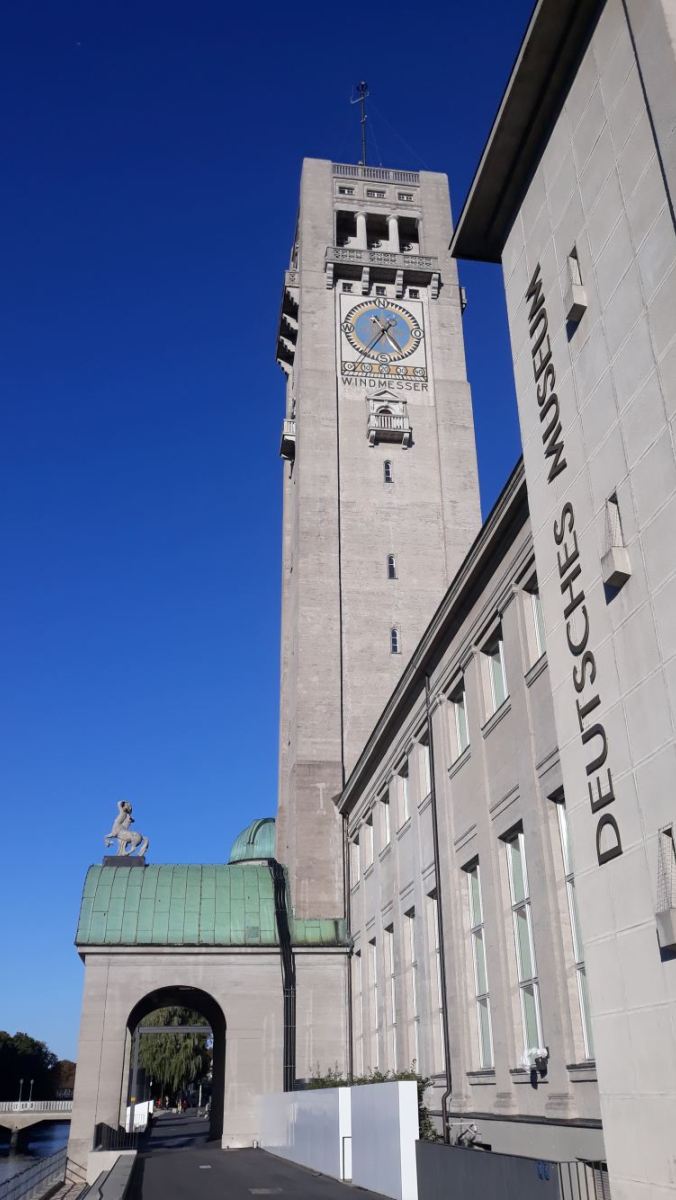
Im September hat Christian die diesjährige Veranstaltungsreihe „Wissenschaft für jedermann“ des Deutschen Museums in München eröffnet. In seinem circa einstündigen Vortrag beleuchtete er die meteorologische Seite der Energiewende und berichtete von aktueller Forschung aus dem LSDPatKIT Team unter anderem zu Fabian’s Arbeiten zu Dunkelflauten in Deutschland. Im Anschluss gab es eine angeregte Diskussion mit dem interessierten Publikum und teils kritischen Fragen zum Klimawandel. Informationen zum Vortrag findet man unter diesem Link https://www.deutsches-museum.de/museumsinsel/programm/veranstaltung/wetter-witterung-dunkelflauten und ein Live Mitschnitt ist auf Youtube:
12/09/2022 - LSDP@KIT at the Annual Meeting of the European Meteorological Society in September 2022
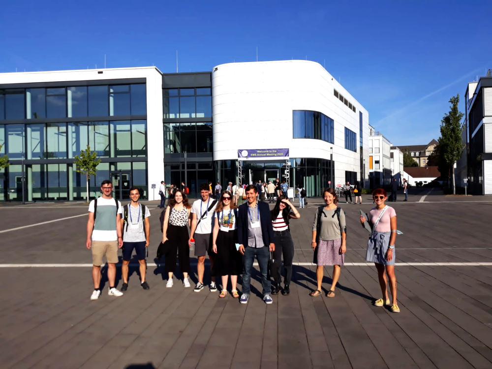
Most of the Large-Scale Dynamics and Predictability group participated in the 2022 Annual Meeting of the European Meteorological Society (EMS) that took place at the Poppelsdorf Campus of the University of Bonn (Germany) from September 5-9, 2022. The team contributed to various sessions, covering a wide range of themes at EMS.
On the first conference day, Fabian presented his Bachelor thesis research on the climatology of Dunkelflauten in Germany and their relationship to weather regimes in the ‘Energy Meteorology’ session. At the same time, Josh gave insights into a tool he developed in his Waves to Weather transfer project to identify large-scale dynamical precursors to European extreme precipitation in the ‘Forecasting, nowcasting and warning systems’ session. Annika discussed her poster entitled ‘Quantifying the role of uncertainty in microphysical processes for cloud and precipitation formation in an extratropical cyclone’ in a session about methodological advances for the accurate representation of physical processes on multiple scales.
On the other conference days, the remaining talks and posters of the group were mainly part of the “Atmospheric dynamics, predictability, and extremes” session that was convened by Christian or in the “Sub-seasonal to seasonal predictability: Processes, methods, and impacts” session that was co-convened by our former group member Dominik Büeler. Marisol gave a talk about the sub-seasonal prediction of the year-round Atlantic-European weather regimes and Jan presented his PhD results about the role of warm conveyor belts (WCBs) for the sub-seasonal prediction of blocked weather regimes. Maria showed her recent research on the optimal Atlantic-European Blocking precursors by using a linear inverse model and Josh discussed the question ‘How do Euro-Atlantic regimes respond to climate change?’. Seraphine presented her study on Greenland Blocking regime dynamics from a potential vorticity perspective in ERA5 and Marta talked about air-sea interactions and diabatic processes in the Gulf Stream region and their role in the life cycle of a blocking anticyclone. On the last day, Annika presented our group study on the predictability of the Western North American heatwave in June 2021 and Moritz gave a talk about the role of WCBs for medium-range forecast error growth.
We really enjoyed attending an in-person conference again, and it was great being there as a big group and benefited from fruitful in-person discussions. Thanks to the EMS annual meeting organiser for a great conference and well-organised event.\SH/MW/JD
03/06/2022 - In search of the culprit for mispredictions of high-pressure situations
Persistent high-pressure systems, also known as blocking, are often associated with heat waves in summer and cold air outbreaks in winter. Accordingly, reliable forecasts of these systems are of enormous importance due to the extensive socio-economic effects.
However, forecasts of persistent high-pressure systems over the European region are still challenging for numerical weather prediction (NWP) and climate models. This manifests in an underestimation of the blocking frequency or reduced forecast skill compared to other large-scale flow regimes [1]. The reduced skill partly arises from a lower intrinsic predictability [2], but might also be due to a misrepresentation of important physical processes in NWP and climate models.
A first-order process for the onset and maintenance of blocking is latent heat release (LHR) due to cloud formation [3] inside so-called warm conveyor belts (WCBs). WCBs are poleward moving air streams that ascend in the warm sector of low-pressure systems within two days from the lowest 2 km of the troposphere to altitudes of 8-12 km. Despite the impact of WCBs on blocking, the link between WCB activity and the prediction of blocking over Europe has not yet been evaluated. For this purpose, newly developed machine learning models [4] are used to compute the WCB activity in a large data set (20 years) of weather forecasts from the NWP model of the European Center for Medium-Range Weather Forecasts (ECMWF).
Around the onset of blocking over Europe, WCB activity is strongly enhanced over the western part of the developing block (Fig. 1). In the NWP model, the WCB frequencies are underestimated across different time scales which indicates that the WCB potentially plays an important role for the overall low forecast skill of blocking over Europe. The WCB activity is better represented during blocking events which are well predicted by the model (Fig. 2a) and strongly underestimated for events with low predictive skill in the model (Fig. 2b). Further investigations show that the underestimation of WCB activity is especially pronounced over the eastern North Atlantic and western Europe prior to the onset of the block [5]. Consequently, the model establishes the block via a different pathway with high WCB activity over the central North Atlantic instead.
In summary, our results highlight the importance of processes in ascending airstreams for the predictability of persistent high-pressure systems over Europe. In particular, we point to the importance of improving the representation of physical processes inside WCBs over the eastern Atlantic and Europe, regions where WCB forecast skill is generally lowest [6]. In the long-term, improving the representation of WCBs will likely yield better predictions of blocking over Europe in NWP and climate models.\JW
References
[1] Büeler, D., Ferranti, L., Magnusson, L., Quinting, J. F., Grams, C. M. (2021). Year-round sub-seasonal forecast skill for Atlantic-European weather regimes. Quarterly Journal of the Royal Atmospheric Society, https://doi.org/10.1002/qj.4178
[2] Hochman, A., Messori, G., Quinting, J. F., Pinto, J. G., & Grams, C. M. (2021). Do Atlantic‐European Weather Regimes Physically Exist?. Geophysical Research Letters, 48(20), https://doi.org/10.1029/2021GL095574
[3] Pfahl, S., Schwierz, C., Croci-Maspoli, M., Grams, C. M., & Wernli, H. (2015). Importance of latent heat release in ascending air streams for atmospheric blocking. Nature Geoscience, 8(8), 610-614, https://doi.org/10.1038/ngeo2487
[4] Quinting, J. F., & Grams, C. M. (2022). EuLerian Identification of ascending AirStreams (ELIAS 2.0) in numerical weather prediction and climate models–Part 1: Development of deep learning model. Geoscientific Model Development, 15(2), 715-730, https://doi.org/10.5194/gmd-15-715-2022
[5] Wandel, J., Quinting, J. F., Büeler, D., Knippertz, P., Grams, C. M. (2022). Why moist dynamic processes matter for the prediction of atmospheric blocking over Europe, in revision
[6] Wandel, J., Quinting, J. F., & Grams, C. M. (2021). Toward a Systematic Evaluation of Warm Conveyor Belts in Numerical Weather Prediction and Climate Models. Part II: Verification of operational reforecasts. Journal of the Atmospheric Sciences, https://doi.org/10.1175/JAS-D-20-0385.1
01/05/2022 - Welcome Fabian Mockert

We welcome Fabian Mockert as a new PhD student in the “Large-Scale Dynamics and Predictability” group. Fabian is the first “MathSEE Bridge PhD” student at IMK working on the interface of Mathematics and Meteorology in projects jointly advised by Sebastian Lerch, Julian Quinting and Christian Grams. In his PhD he will explore machine learning approaches and modern post-processing techniques to provide hybrid forecasts of weather regimes at different lead times. This seamless approach envisions to use the dynamical numerical model forecasts in the first days but to transition to more statistical forecasts for sub-seasonal lead times.
Fabian already has a diverse history at KIT. He first did a Bachelor’s degree in physics. Still his BSc thesis was already in an interdisciplinary project exploring meteorological drivers and characteristics of periods of low power output in energy systems with a very high share of renewables. He then switched to the Master’s programme at IMK just graduating in April. In his - again interdisciplinary - MSc thesis Fabian used a hierarchy of machine learning models to assess how well AI can predict forecast skill compared to classical ensemble approaches. Fabian won a MeteoXchange travel stipend which allowed him to visit Reading in April working more on Dunkelflauten and networking with graduate students there. We are happy to welcome you back in the team and starting the next MathSEE adventure with you.
24/03/2022 - Welcome Josh Dorrington

We welcome Dr Joshua Dorrington as a new Postdoc in the “Large-Scale Dynamics and Predictability” group. Josh will work in the Waves to Weather transfer project “TeX” (Towards seamless prediction of extremes). Together with colleagues at LMU Munich and ECWMF we will explore how to make use of knowledge about the dynamical processes causing large-scale extreme events to identify precursors at different forecast lead times and make use of them in weather forecasting – or in short: How to bring more dynamical thinking into the forecasting and warning of extreme events.
Josh recently defended his PhD in Physics at the University of Oxford, UK. In his PhD, under the supervision of Tim Palmer and Antje Weisheimer, he studied weather regimes in the Atlantic-European region, in both low-dimensional conceptual models and global climate models. In particular he investigated the multi-decadal variability of regimes, relations between the eddy-driven jet and circulation regimes, and the response of regimes to external forcing. He also has worked on sub-seasonal forecasting for the European energy sector, and has an interest in the application of ideas from dynamical systems theory to atmospheric dynamics.
We wish Josh a great start at IMK-TRO and lots of fun with his work and colleagues.
14/03/2022 - One-sided effect of stochastic perturbations in ensemble forecasts on rapidly ascending air streams
Numerical weather prediction (NWP) is subject to uncertainties due to the chaotic behaviour of the atmosphere. In order to take these uncertainties into account, so-called ensemble forecasts are carried out, which calculate not only one, but several possible evolutions of the atmospheric state. The range of predicted scenarios (the ensemble spread) allows an estimation of the forecast uncertainty and, according to the so-called spread-error ratio, also of the forecast skill [1].
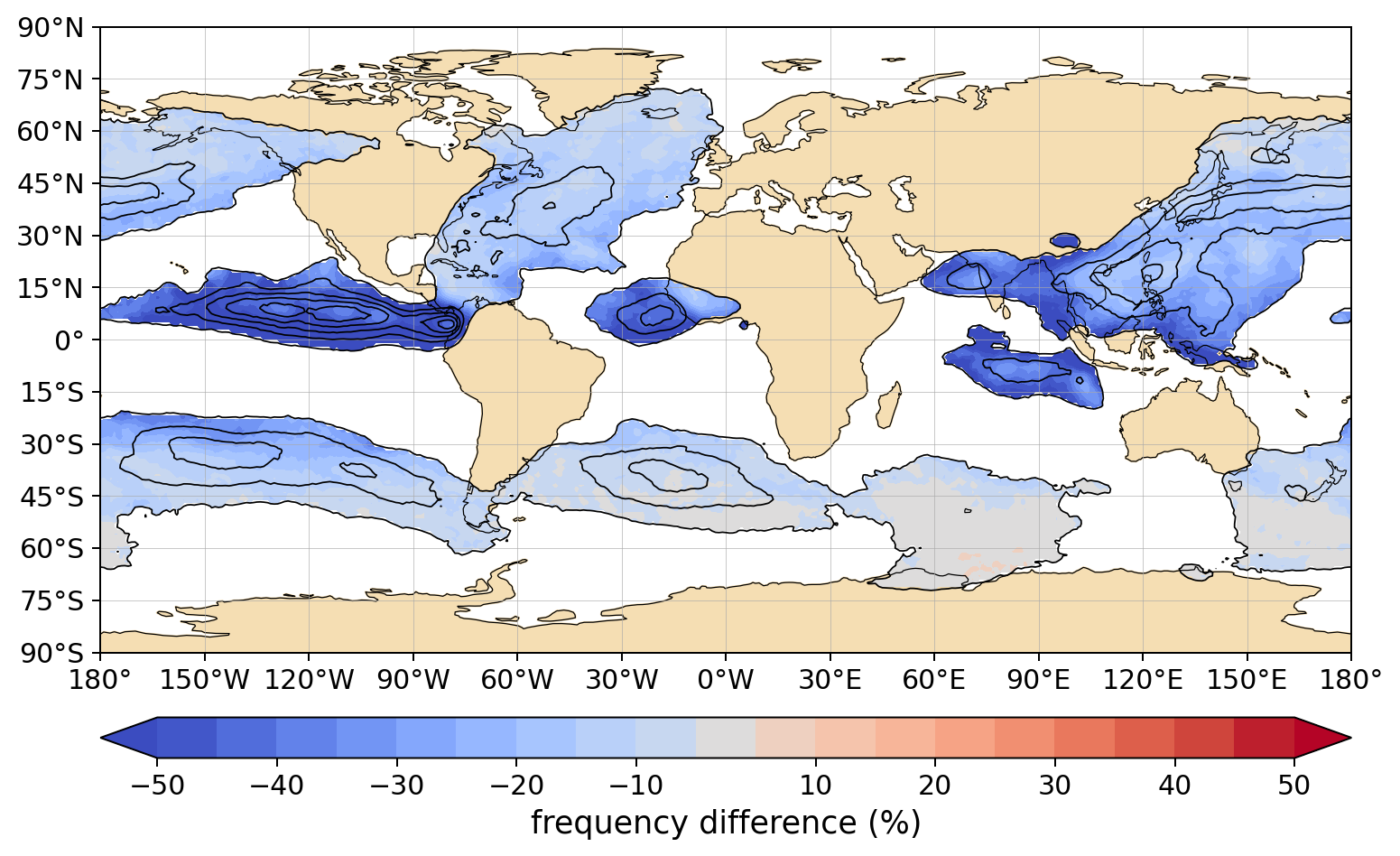
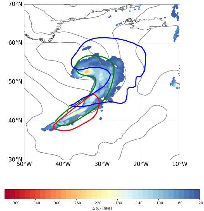
Figure 1: Relative differences (colour shading) of the outflow frequencies of rapidly ascending air streams between a reference experiment with SPPT and initial condition perturbations and an experiment without SPPT. Only differences are shown in which the absolute frequency of the reference experiment (black contours of 5% steps between 5 and 25%) is at least 5%. The differences are based on 32 forecasts between mid-August and mid-October 2016 with 20 ensemble members each over 10 forecast days.
At the European Centre for Medium-Range Weather Forecasts (ECMWF), ensemble forecasts are produced by starting the individual model runs from slightly modified initial conditions, thereby taking into account uncertainties in the estimation of the initial state from meteorological observations. In addition, perturbations are introduced during the simulation to represent the sources of error in the programme code and in the formulation of the forecast model. These perturbations are currently generated using the stochastically perturbed parametrization tendencies (SPPT) scheme. SPPT is designed to introduce perturbations primarily where physical processes occur that cannot be resolved directly by the model [2]. For example, condensation and cloud formation occur on such small scales that even today's "high-resolution" models with grid sizes of 9km and more do not resolve these processes, but must approximate them using empirical relationships (so-called parametrizations).
A weather system that is strongly influenced by diabatic processes is the so-called Warm Conveyor Belt (WCB), a moist-warm air stream that typically ascends from the boundary layer of the warm sector of low-pressure systems into the upper troposphere within 1-2 days. During the ascent, water vapour condenses and latent heat is released. Since these processes have to be parametrized in NWP models, SPPT introduced perturbations of large magnitude in such situations.
In a newly published study [3], which was conducted in the working group "Large-scale Dynamics and Predictability" in collaboration with colleagues at ECMWF, we investigated if and how SPPT affects WCBs and other rapidly ascending air streams that are influenced by diabatic processes, thereby providing a weather system perspective on stochastic perturbations. Our results show that in forecasts with SPPT there are systematically more rapidly ascending air streams without changing their physical properties. The magnitude of this effect depends on how much latent heat is released during the ascent: While in the tropics with SPPT in some cases more than twice as many such air streams occur than in unperturbed forecasts, in the extratropics, where latent heating rates are lower, the value amounts to an increase of about 10-20% (Figure 1). This increase in occurrence frequencies leads to an improvement in the prediction of such air streams, especially in the (sub-) tropical regions, because their frequency is systematically underestimated there. As such rapidly ascending air streams are closely related to the formation of precipitation, SPPT also changes the global precipitation distribution.
With our study, we were able to show somewhat surprisingly that SPPT, despite its symmetric and zero-mean perturbations, has a one-sided effect on the frequency of WCBs and other rapidly ascending air streams. This behaviour is a result of the interaction of the perturbations with non-linear processes characterised by threshold behaviour, e.g. in the initiation of convection (Figure 2).
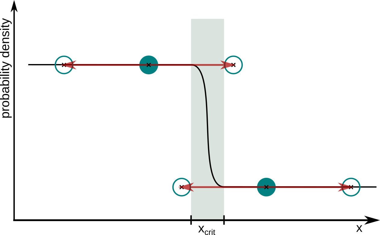
Figure 2: Schematic representation of the effect of symmetric perturbations (red arrows) in a non-linear system that is unstable above the threshold xcrit.
14/01/2022 - Welcome Maria Madsen

We warmly welcome Dr Maria Madsen as a guest in the “Large-Scale Dynamics and Predictability” group. Maria is a PostDoc in Waves to Weather project A8 at JGU Mainz. Together with the A8 Team Maria will explore remote influences on blocked weather regimes in the North Atlantic European region using linear inverse modelling (LIM).
Maria just received a PhD in Meteorology from the University of Wisconsin, Madison, USA. In her PhD research she applied self-organising maps to identify different states of the North Pacific jet and investigated in detail their physical characteristics and downstream impacts for North American surface weather. At the same time Maria became an expert in LIM and applied it to better understand North Pacific jet regime transitions and their consequences for predictability of North American weather. We wish Maria a great start at IMK-TRO and lots of fun with her work and colleagues.
29/10/2021 - International Workshop on Atmospheric Blocking
Atmospheric blocking describes a flow situation characterized by quasi-stationary and persistent high-pressure systems. These high-pressure systems block the usual mid-latitude westerlies so that low pressure systems embedded therein can be held stationary at the flanks. Blocking events are associated with regional extreme weather events such as heatwaves and cold spells, and flooding. Physical processes involved in blocking are not yet fully understood, and skillful predictions of the formation and maintenance of blocking anticyclones remain a challenge for numerical weather prediction and climate models.
A virtual workshop on the dynamics of atmospheric blocking, co-organized by researchers from IMK-TRO, was held from 27-29 September 2021 [1]. Following the first successful Blocking Workshop in Reading in 2016 [2], this event offered a platform to bring together experts in the field of atmospheric and climate science during the Covid-19 pandemic, to review the current state of research, and to discuss the most important open questions regarding blocking. The idea of organizing this workshop was initiated by “Waves to Weather” scientists Franziska Teubler (at Johannes Gutenberg University, Mainz) and Seraphine Hauser at the Karlsruhe Institute of Technology, Karlsruhe (KIT), in early 2021 with the aim of scientific exchange on atmospheric blocking during the ongoing Covid-19 pandemic. The Transregional Collaborative Research Center “Waves to Weather” [3] volunteered to sponsor and host the workshop and was highly involved in the organization and planning of the event. The organizing committee that additionally consisted of Volkmar Wirth (at Johannes Gutenberg University, Mainz) and Daniel Steinfeld (at University of Bern, Switzerland), was supported by a scientific committee led by Dr. Christian Grams (KIT, IMK-TRO).
The focus of this online workshop was set on the understanding of dynamics and physical processes in atmospheric blocking, with special focus on (i) the role of dry and moist dynamics in the formation, maintenance, and decay of blocking, (ii) teleconnections and external forcing modulating the occurrence of blocking, and (iii) model representation and predictability of blocking dynamics and physical processes. With nearly 60 contributions by scientists from all parts of the world and with more than 170 participants, the workshop attracted a lot of international attention. The 3-day program of the workshop consisted of seven oral sessions, introduced by renowned keynote speakers, two poster sessions and two breakout group discussions dedicated to the topics mentioned above. We were particularly happy about an honorary lecture by Sir Brian Hoskins, who gave an overview of the history of research on blocking. Overall, the workshop went smoothly without technical difficulties, and although the program was very dense, there was enough time for further exchange during the coffee breaks.
More information on the workshop, the detailed program, the keynote speakers, and the organizing and scientific committee can be found on the official Blocking Workshop 2021 website [1].\SH
References:
[1] Official Website of Atmospheric Blocking Workshop 2021: https://blocking-workshop-2021.wavestoweather.de/index.html
[2] Webpage of Atmospheric Blocking Workshop in 2016: http://www.met.reading.ac.uk/~ben/blocking2016/
[3] Waves To Weather: https://www.wavestoweather.de/
22/10/2021 - First systematic verification of warm conveyor belts in weather prediction models
Warm conveyor belts (WCBs) are poleward moving air streams that ascend in the warm sector of low-pressure systems within two days from the lowest 2 km to the upper troposphere at a height of 8-12 km. During the ascent, condensation and the formation of cloud droplets is associated with the release of latent heat. These so-called diabatic processes are important for the properties of the rising air masses, the intensity of the air mass transport in the upper troposphere, and the impact on the atmospheric dynamics at an altitude of 8-12 km. The air masses can contribute significantly to the formation of high-pressure systems, their amplification, and their persistence over a certain region. Such persistent high pressure systems are often associated with heat waves in summer and cold air outbreaks in winter. Correspondingly, a reliable forecast is of enormous importance for socio-economic activities. Compared to other weather types, forecasting persistent high-pressure weather conditions over Europe is still a major challenge for current numerical weather prediction models [1].
The young investigator group "Large-scale Dynamics and Predictability" tackles these challenges within the project "SPREADOUT" (Sub-seasonal predictability: understanding the role of diabatic outflow) and examines the influence of diabatic processes in the WCB on the large-scale flow and its representation in numerical weather prediction models. For this purpose, we develop statistical diagnostics [2][3][4], which for the first time enable to compute the WCB activity in a large data set of weather forecasts spanning the last 20 years.
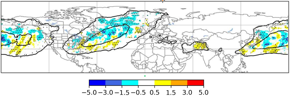
Our results show that the numerical weather prediction model of the European Center for Medium-Range Weather Forecasts (ECMWF) systematically underestimates the WCB activity in certain regions over the North Atlantic and North Pacific as early as three days after the forecast was initialized [5]. These errors in the model continue to grow in the following 10 forecast days and then remain constant. In particular, the relative underestimation of WCB occurrence by around 10% over the Atlantic is a first indication that there is a connection between the underestimation of WCB activity and the underestimation of persistent high-pressure systems over Europe found at a similar magnitude in several studies. Further, we find that the forecast of a WCB occurrence at a given location is possible up to around 8-10 days in the future which corresponds well to the forecast horizon of low-pressure systems in numerical models. The errors in the WCB activity can be attributed to errors in the moisture transport in the lower and middle layers of the troposphere (1-5 km altitude). This information is important to model developers as it indicates a potential pathway to improve weather prediction, especially for forecasts on sub-seasonal time scales beyond 10 days.
Overall, our study for the first time provides a systematic assessment of WCB activity in a numerical weather prediction model and suggests that a better representation of the processes in the WCB can lead to an improvement in the prediction of persistent high-pressure systems. Such a link between WCBs and various large-scale weather systems is part of our ongoing research.\JW
Literature:
[1] Büeler, D., Ferranti, L., Magnusson, L., Quinting, J. F., Grams, C. M. (2021). Year-round sub-seasonal forecast skill for Atlantic-European weather regimes. Quarterly Journal of the Royal Atmospheric Society, https://doi.org/10.1002/qj.4178
[2] Quinting, J. F., & Grams, C. M. (2021). Toward a Systematic Evaluation of Warm Conveyor Belts in Numerical Weather Prediction and Climate Models. Part I: Predictor Selection and Logistic Regression Model. Journal of the Atmospheric Sciences, 78(5), 1465-1485, https://doi.org/10.1175/JAS-D-20-0139.1
[3] Quinting, J. F., & Grams, C. M. (2021). EuLerian Identification of ascending Air Streams (ELIAS 2.0) in Numerical Weather Prediction and Climate Models. Part I: Development of deep learning model. Geoscientific Model Development, in discussion. https://doi.org/10.5194/gmd-2021-276
[4] Quinting, J. F., C. M. Grams, A. Oertel, and M. Pickl, (2021): EuLerian Identification of Ascending air Streams (ELIAS 2.0) in Numerical Weather Prediction and Climate Models. Part II: Model application to different data sets. Geoscientific Model Development Discussions, 1–24, https://doi.org/10.5194/gmd-2021-278
[5] Wandel, J., Quinting, J. F., & Grams, C. M. (2021). Toward a Systematic Evaluation of Warm Conveyor Belts in Numerical Weather Prediction and Climate Models. Part II: Verification of operational reforecasts. Journal of the Atmospheric Sciences, https://doi.org/10.1175/JAS-D-20-0385.1
07/10/2021 - Welcome Marta Wenta

We warmly welcome Dr Marta Wenta as a new postdoc in the “Large-Scale Dynamics and Predictability” group. Marta will work in the German-Swiss project “GULFimpact: The role of coherent air streams in shaping the Gulf stream’s impact on the large-scale extratropical circulation”. The project will explore how air mass transformations due to air-sea interaction along the Gulf stream oceanic front, latent heat release in cyclones, and cold air outbreaks from the Arctic affect the large-scale circulation over the North Atlantic and Europe.
Marta just received a PhD in Earth and Environmental Sciences from the University of Gdańsk for her doctoral research on numerical modelling and observations of the atmospheric boundary layer in polar regions, in particular at the ocean – sea-ice – atmosphere interface. Her research included the organisation and participation of measurement campaigns in collaboration with international partners at – amongst others – CIRES, Boulder and the Finnish Meteorological Service. We wish Marta great success at IMK-TRO and lots of fun with her future work and colleagues.
29/09/2021 - Welcome Marisol Osman

We welcome Dr Marisol Osman as a new postdoc in the “Large-Scale Dynamics and Predictability” group. Marisol will work in a collaborative project with AXPO Solutions AG and assess weather forecast performance on medium-range and subseasoanal forecast horizons for better meteorological guidance in energy trading. A specific focus lays on exploiting windows of forecast opportunity with respect to weather regimes.
Marisol is an experienced researcher in subseasonal to seasonal (S2S) predictability. Her past research focused on climate variability and predictability in the extratropical southern hemisphere arising from – amongst others – tropical heating such as the ENSO teleconnection or from polar latitudes. In addition, she worked extensively on making use of climate information for various stake-holders. Marisol implemented the seasonal forecasting system for the Argentine Meteorological Service which she developed during her PhD in Atmospheric and Ocean Sciences at the University of Buenos Aires and developed S2S forecasting tools for agriculture in Argentina. Finally, Marisol was Executive Committee Member of the international YESS (Young Earth System Scientists) early career scientists network (http://yess-community.org). We wish Marisol a warm welcome at IMK-TRO and lots of fun with her future work and colleagues.
02/06/2021 - How far into the future can we predict large-scale weather?
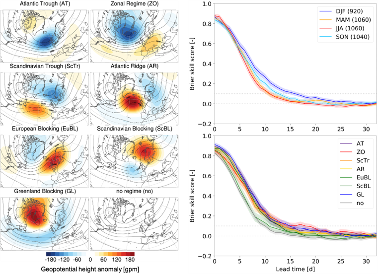
Some decades ago, weather forecasts more than two weeks ahead were hard to imagine. Today, certain weather apps claim to be able to tell us whether the planned barbecue party three weeks ahead will or will not drown in rain. Are forecasts like these trustworthy? Indeed, the last few decades were characterized by a rapid increase in computational power and a continuous improvement of numerical weather prediction modeling systems. This has allowed weather forecasting centers to provide forecasts that go beyond two weeks, which is commonly referred to as extended-range or sub-seasonal lead times. Nevertheless, such sub-seasonal forecasts still have moderate to weak skill and are thus a growing field of research. Since the highly chaotic nature of the atmosphere will never allow us to predict a local shower in three weeks from now, sub-seasonal forecasts aim to predict the occurrence probability of large-scale weather conditions, such as weather regimes. These are large-scale weather patterns in the midlatitude atmosphere that persist for several days to weeks and modulate regional surface weather in characteristic ways. As numerous socio-economic sectors such as the energy industry, national health services, or agriculture are strongly influenced by the evolution of such weather regimes [1, 2, 3], it is important to understand how well they can be predicted by state-of-the-art sub-seasonal weather models.
Previous studies have primarily evaluated sub-seasonal weather regime forecasts in winter, when the atmosphere tends to be most predictable. A new study of our research group in collaboration with colleagues at the European Centre for Medium-Range Weather Forecasts (ECMWF) [4] has investigated for the first time how well the sub-seasonal ECMWF (re)forecasts predict a set of seven Atlantic-European weather regimes (Fig. 1, left) throughout the year. A first key finding is that errors in regime occurrence frequency are largest in summer and smallest in winter. Some of these occurrence frequency errors can be explained by consistent errors in regime duration, the number of regime life cycles, and the transitions between regimes. A second key finding is that regimes can be skillfully predicted up to about two weeks ahead. In winter, the regime skill horizon is about 5 days longer than in summer and spring, and about 3 days longer than in fall (Fig. 1, top right). The year-round skill horizon tends to be longest for the Zonal Regime and the Greenland Blocking, which is driven by their high persistence in winter that allows skillful predictions beyond 3 weeks. In contrast, the skill horizon is 3 to 5 days shorter for the European Blocking than for all the other regimes (Fig. 1, bottom right), which is common for all seasons but most pronounced in winter and spring.
The study further elucidates windows of opportunity for enhanced sub-seasonal regime forecast skill. First, predicting a regime within a multi-day lead time window rather than day-by-day increases the skill horizon by several days. Second, global teleconnections varying on slower (seasonal) timescales can provide sub-seasonal predictability in the midlatitudes. Two important such teleconnections arise from the stratospheric polar vortex (SPV) in winter (see also our previous news article), and tropical convection organized in the Madden-Julian Oscillation (MJO). The study shows that the average winter regime skill horizon tends to be enhanced following an anomalously strong SPV but reduced following an anomalously weak SPV at forecast initialization. Likewise, the year-round regime skill tends to be enhanced when tropical convection related to the MJO is located over the Maritime Continent and the western to central Pacific but reduced when it is located over the Indian Ocean.
In conclusion, it is impossible to predict whether a local shower will drown our barbecue party in three weeks. However, we can make valuable estimates on the predominant large-scale weather conditions several weeks ahead, which can be of enormous socio-economic potential. The confidence in these estimates strongly depends on the situation: for instance, it is much more likely to correctly predict a long-lasting mild phase induced by a Zonal Regime or a cold wave induced by a Greenland Blocking in winter than it is to predict a heat wave induced by a European Blocking in summer. Despite these existing windows of opportunity, there is promising potential for further model improvements: for instance, the relatively poor sub-seasonal forecast skill in summer might be improved by further reducing the large-scale circulation errors in summer. Likewise, the skill horizon in winter might be further extended by improving the model’s ability to correctly represent in particular weak SPVs and specific MJO phases. Finally, it is important to better understand and thus model the processes driving blocking over Europe, which is a focus of the ongoing research in our group. Considering the expected increase in heat waves associated with blocking in a changing climate, this should even be put on the top of the priority list.\DB
[1] Beerli, R., and Grams, C. M., 2019: Stratospheric modulation of the large-scale circulation in the Atlantic-European region and its implications for surface weather events. Q. J. R. Meteorol. Soc., 145, 3732–3750, https://doi.org/10.1002/qj.3653
[2] Charlton-Perez, A. J., Aldridge, R. W., Grams, C. M., and Lee, R., 2019: Winter pressures on the UK health system dominated by the Greenland Blocking weather regime. Weather Clim. Extremes, 25, 100218, https://doi.org/10.1016/j.wace.2019.100218
[3] White, C. J., …, C. M. Grams, D. Büeler, …, et al., 2021: Advances in the application and utility of subseasonal-to-seasonal predictions. Submitted to Bull. Amer. Meteor. Soc.
[4] Büeler, D., Ferranti, L., Magnusson, L., Quinting, J. F., and Grams, C. M., 2021: Year-round sub-seasonal forecast skill for Atlantic-European weather regimes. Q. J. R. Meteorol. Soc., accepted, https://doi.org/10.1002/qj.4178
05/02/2021 - Artificial intelligence helps to verify processes in NWP and climate models
Physical processes on the weather time-scale importantly modulate the large-scale midlatitude circulation. In particular, the most rapidly ascending air streams in extratropical cyclones, so-called warm conveyor belts (WCBs), have a major impact on the dynamics and are sources and magnifiers of forecast uncertainty. Thus, an adequate representation of WCBs is desirable in numerical weather prediction and climate models. Most often, WCBs are defined on the base of Lagrangian trajectories which are computationally expensive to calculate and require data at high spatio-temporal resolution. Thus, systematic evaluations of the representation of WCBs in large numerical weather prediction (NWP) and climate model data sets are missing.
A major goal of the Helmholtz Young Investigator Group “Sub-seasonal Atmospheric Predictability: Understanding the Role of Diabatic Outflow” (SPREADOUT) at IMK-TRO is to develop statistical techniques that allow the identification of WCBs without performing expensive trajectory computations [1]. Most recently, convolutional neural network (CNN) models were trained to predict the occurrence of WCBs using a combination of meteorological predictors which are physically meaningful to describe the WCB and which are routinely available in NWP forecast and climate model projections. The validation of the CNN models against a trajectory-based data set confirms that the deep learning based approach reliably replicates the climatological frequency of WCBs as well as their footprints at instantaneous time steps [2].
With its comparably low computational costs the new deep learning based diagnostic is ideally suited to systematically verify WCBs in large datasets such as ensemble reforecast or climate model projections. Further, the diagnostic can be easily applied to different modeling systems such as the ICON NWP model (Fig. 1). Accordingly, model intercomparisons concerning the representation of WCBs will be conducted in future studies. A first systematic verification of WCBs in ECMWF‘s subseasonal to seasonal reforecasts highlights that significant systematic biases in the occurrence frequency of WCBs exist (Fig. 2) and that reliable predictions of WCBs are not possible beyond 10 days forecast lead time [3].
Overall, the novel diagnostic demonstrates how deep learning methods may be used to advance our fundamental understanding of processes on the weather time-scale that are involved in forecast uncertainty and systematic biases in NWP and climate models.\JQ
References:
[1] Quinting, J. F., & Grams, C. M. (2021). Toward a Systematic Evaluation of Warm Conveyor Belts in Numerical Weather Prediction and Climate Models. Part I: Predictor Selection and Logistic Regression Model, Journal of the Atmospheric Sciences, 78, 1465-1485, https://doi.org/10.1175/JAS-D-20-0139.1
[2] Quinting, J. F. & Grams, C. M. (2021): EuLerian Identification of ascending Air Streams (ELIAS 2.0) in Numerical Weather Prediction and Climate Models. Part I: Development of deep learning model, Geosci. Model Dev. Discuss., https://doi.org/10.5194/gmd-2021-276, in review
[3] Wandel, J., J. F. Quinting, C. M. Grams (2021). Towards a systematic evaluation of warm conveyor belts in numerical weather prediction and climate models. Part II: Verification of operational reforecasts. Journal of Atmospheric Sciences, accepted.
21/01/2021 - Christian Grams awarded with prestigious 3-year ECMWF Fellowship

Christian Grams’ years of process-oriented research on improving sub-seasonal atmospheric predictions have been awarded with the prestigious 3-year ECMWF Fellowship starting this January. As one of seven new ECMWF Fellows, Christian (together with our research group) will have the opportunity to work even more closely with our colleagues at ECMWF. The Fellowship will be hosted in the Earth Predictability Section led by Magdalena Balmaseda. Frédéric Vitart, a world-leading expert on sub-seasonal atmospheric predictability, will serve as direct host. The partnership will involve regular scientific exchange, joint publications and reports (outcomes of prior collaborations are listed below), research visits at ECMWF in Reading (as soon as the pandemic situation allows it), and access to ECMWF’s operational forecast data and computing facilities. With the fellowship programme, ECMWF aims to target their research collaborations in a way to better achieve their long-term scientific objectives. Extending the weather forecast skill horizon into sub-seasonal timescales is one of their ambitious objectives and at the same time one of the key foci of our research group. In the name of our whole research group, we would like to congratulate Christian for this great achievement and we are very much looking forward to three years of exciting collaboration with colleagues at ECMWF!
Dominik Büeler and Julian Quinting, in the name of the Large-Scale Dynamics and Predictability Group
Grams, C. M., L. Magnusson, and L. Ferranti, 2020: How to make use of weather regimes in extended-range predictions for Europe. ECMWF, https://www.ecmwf.int/en/newsletter/165/meteorology/how-make-use-weather-regimes-extended-range-predictions-europe
Grams, C. M., L. Magnusson, and E. Madonna, 2018: An atmospheric dynamics perspective on the amplification and propagation of forecast error in numerical weather prediction models: A case study. Q. J. R. Meteor. Soc., 144, 2577–2591, doi:10.1002/qj.3353
Quinting, J. F., and F. Vitart, 2019: Representation of synoptic-scale Rossby wave packets and blocking in the S2S Prediction Project database. Geophys. Res. Lett., 46, 1070–1078, doi:10.1029/2018GL081381
Schäfler, A., and Coauthors, 2018: The North Atlantic Waveguide and Downstream Impact Experiment. Bull. Amer. Meteor. Soc., 99, 1607–1637, doi:10.1175/BAMS-D-17-0003.1
14/12/2020 - LSDP-Team at AGU2020 online
Several of us are attending the AGU annual meeting 2020 – online. Despite long chat sessions and night shifts this is a great opportunity to get up to date about the recent research activities in the community and to present our latest results.
Annika Oertel presents our Wave2Weather project with Corinna Hoose and Annette Miltenberger on microphysical sensitivities in WCBs in Poster A096-0007. In addition Annika will have an invited presentation on her PhD results on the role of embedded convection and negative PV in WCBs and its relevance for the larger scales on Monday 14th December 20:30-21:30 PST (15 Dec 04:30-05:30 UTC) talk A171-06.
On Wednesday 16th December 4:00-20:59 PST (12 UTC to 5 UTC+1d) SPREADOUT scientists Dominik Büeler and Jan Wandel will present our work on how synoptic-scale processes affect S2S prediction. Dominik will discuss the representation and forecast skill for our year-round Atlantic-European weather regimes in poster A226-0003. Jan will introduce our Eulerian WCB metric and discuss insights from the first systematic verification of WCBs in a numerical weather prediction model in poster A226-0011.
Unfortunately, you have to be a registered AGU2020 attendee to get access to our contributions. Feel free to contact us for discussions! /CMG
08/12/2020 - Recent Outreach and Public Lectures
During the last weeks we had two opportunities to present work from the LSDP team to broader audience.
In a public science lecture contributing to the CVAS Seminar Series at University of Heidelberg on 26 November 2020, Christian explained surface climate variability on synoptic to subseasonal time scales to students and members of the PAGES community. The recording is available here on YouTube and the full playlist of the CVAS seminar series as well.
On 8 December 2020 Michael Kunz, Peter Knippertz and Christian took part in the science festival EFFEKTE in Karlsruhe. For the Dezember-Edition they gave presentations on weather forecast (P. Knippertz), extreme weather (M. Kunz), and renewable energy (C. Grams), took part in discussions with the journalist Hanna Sophie Lüke, and with the audience via a live chat. The recording is available on YouTube as well (in German), Christian’s part (20 min presentation + 10 min interview) starts from 1h 28min.
15/11/2020 - Contribution to ECMWF newsletter on the use of weather regimes in extended-range weather forecasts
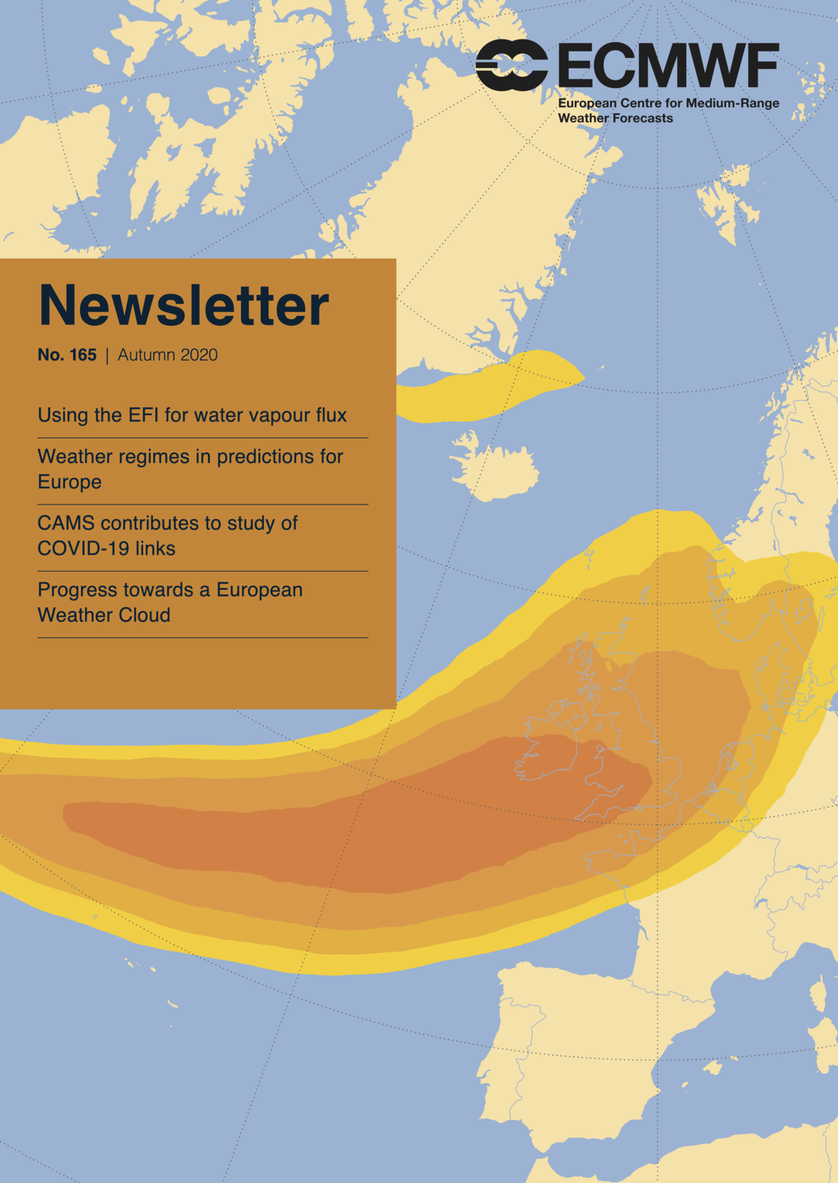
Christian Grams wrote an insightful article together with our ECMWF colleagues Laura Ferranti and Linus Magnusson in the ECMWF Newsletter No. 165 (Autumn 2020). It is entitled "How to make use of weather regimes in extended-range predictions for Europe" and, for instance, convincingly demonstrates that the North Atlantic Oscillation is enough to explain atmospheric variability in some situations but a higher number of up to 7 weather regimes (with which we extensively work in the SPREADOUT group) is clearly required in other situations. The full article can be found here (pages 14-19).
31/10/2020 - How reliable are long-term weather forecasts following weak polar vortex events?
New insights show that month-ahead temperature forecasts for Europe following sudden stratospheric warmings have to be interpreted with caution.
With the advent of winter, media reports on meteorologists speculating about the possible role of the so-called polar vortex in the Northern Hemispheric stratosphere will become more frequent again. Based on this, they will make predictions whether the coming months, or even the whole winter, will be rather mild and dry in Central Europe or whether we might rather experience cold air outbreaks with large amounts of snow.
Although such predictions might seem highly speculative at first glance, it makes indeed sense to carefully analyze the forecasts for the evolution of the polar vortex (a huge band of westerlies at 60 degrees north stretching from the lower to middle stratosphere at 10 to 50 km height in winter). This is because since some years science largely agrees on the fact that the stratospheric polar vortex provides one of the largest potentials for predictability of European weather on sub-seasonal timescales (15 – 60 days) during winter. This is due to the fact that the polar vortex directly connects to the upper troposphere (up to 10 km height) and thus the jet stream, which dominates the evolution of weather at our latitudes. Particularly in late winter, the polar vortex can weaken abruptly, which is called a “sudden stratospheric warming”. This weakening leads to a stronger meandering of the jet stream, which in turn can cause long-lasting Arctic cold air outbreaks into Europe and North America. In contrast, a particularly strong polar vortex is associated with a strong and zonally oriented jet stream, which causes rather long-lasting mild weather in Europe.
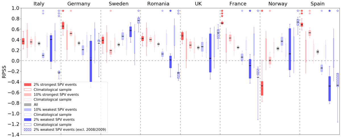
To exploit this large potential for sub-seasonal predictability, it is important that the numerical weather models correctly depict the polar vortex and its coupling with the troposphere. While recent studies often investigated and emphasized the enhanced large-scale predictability following sudden stratospheric warmings, a new study of our group in collaboration with the Swiss energy company Axpo Solutions [1] has come to the conclusion that the sub-seasonal forecasts for weather in Europe in such situations might not be as good as previously assumed. Instead, forecasts have shown to be much more reliable during phases of a particularly strong polar vortex. More specifically, the study has investigated how well the sub-seasonal weather model of the European Centre for Medium-Range Weather Forecasts (ECMWF) predicts country-averaged temperatures in Europe one month ahead, depending on the state of the polar vortex at the beginning of the forecast. This has revealed that the model on average predicts too cold anomalies particularly over Central and Southern Europe after an anomalously weak polar vortex. As a result, the forecast skill is even reduced for some countries (e.g., Spain, France, or Romania) compared to normal stratospheric conditions (see dark blue filled boxes compared to dark blue narrow boxes in Fig. 1). In contrast, the model has shown to predict the warm anomalies over large parts of Europe after an anomalously strong polar vortex remarkably well and thus significantly increase forecast skill for many countries (e.g., Germany, Spain, and France) compared to normal stratospheric conditions (see dark red filled boxes compared to dark red narrow boxes in Fig. 1). These new insights are surprising and important, as they question the regularly assumed enhanced sub-seasonal predictability following sudden stratospheric warmings at least from a regional perspective. At the same time, they show that sub-seasonal regional temperature forecasts following an anomalously strong polar vortex are much more reliable, which has been neglected so far. This becomes evident for countries like France and Spain revealing substantially enhanced forecast skill up to 4 weeks ahead, which is impressive and fascinating.
The reduced forecast skill for some regions following a weak polar vortex strongly indicates potential problems in the model in predicting the large-scale weather conditions, so-called weather regimes, in such situations. Indeed, further new findings of our group show that sub-seasonal forecast skill for weather regimes in Europe is significantly lower following a weak polar vortex compared to a strong polar vortex. Whether this is linked to the fact that the model might struggle to capture one of the very different weather regimes, which climatologically occur after a weak polar vortex [2, 3], is subject of our current research.
Dominik Büeler, Large-scale dynamics and predictability group
[1] Büeler, D., Beerli, R., Wernli, H., and Grams, C. M., 2020: Stratospheric influence on ECMWF sub-seasonal forecast skill for energy-industry-relevant surface weather in European countries. Q. J. R. Meteorol. Soc., https://doi.org/10.1002/qj.3866
[2] Beerli, R., and Grams, C. M., 2019: Stratospheric modulation of the large-scale circulation in the Atlantic-European region and its implications for surface weather events. Q. J. R. Meteorol. Soc., 145, 3732–3750, https://doi.org/10.1002/qj.3653
[3] Domeisen, D. I. V., Grams, C. M., and Papritz, L., 2020: The role of North Atlantic-European weather regimes in the surface impact of sudden stratospheric warming events. Weather Clim. Dynam., 1, 373–388, https://doi.org/10.5194/wcd-1-373-2020
07/05/2020 - Welcome Annika Oertel

We welcome Dr. Annika Oertel as a new postdoc in the „Cloud Physics“ and „Large-Scale Dynamics and Predictability“ groups. As part of the Transregio „Waves to Weather“ she will work on strongly ascending airstreams in extratropical cyclones, so-called warm conveyor belts (WCBs), and investigate the effect of ice microphysical processes on the evolution and intensity of WCBs using ICON and statistical emulation. She will also analyse the interaction between the representation of microphysical processes in WCBs and the large-scale circulation. During her PhD in atmospheric dynamics at ETH Zurich she combined satellite retrievals and radar observations of WCBs with high-resolution convection-permitting simulations to analyse the role of embedded convection in WCBs and its effect on the mesoscale and larger-scale circulation. Annika will be based on Campus South (office 13-5) and Campus North (office 316a, phone 26537) and her email is annika.oertel∂kit.edu. We wish Annika a good start at IMK-TRO and lots of fun with her future work and colleagues.
27/04/2020 - Why does it rain in Australia during El Niño?
Every 3-8 years, a significant increase in water temperature in the equatorial Pacific Ocean causes global changes in temperature and rainfall - El Niño. Though Peru and western North America expect above-average rainfall during El Niño, the densely populated southeastern Australia fears drought conditions and a high risk of bushfires. For example, the last El Niño event in 2015/2016 was classified as the third strongest El Niño event since 1965 and was characterized by long lasting heat waves, a very early start of the bushfire season and a record-breaking drought. Still, El Niño is not necessarily associated with reduced rainfall in southeastern Australia shown by close to average rainfall during the strong El Niño event of 1997/1998. So, why does it rain in Australia during El Niño? Are large-scale atmospheric flow patterns and embedded weather systems responsible for this rainfall variability between similarly strong El Niño events?
In collaboration with Prof. Michael Reeder and Dr. Shayne McGregor from Monash University in Melbourne, these questions were investigated in our research group "Large-scale dynamics and predictability" [1]. By clustering monthly rainfall anomalies between June and November, a total of four monthly rainfall patterns could be found in southeastern Australia (Fig. 1): wet southeastern Australia (Cluster 1), dry southeastern Australia (Cluster 2), wet East Coast (Cluster 3) and wet South Coast (Cluster 4). Nearly 50% of the El Niño months considered are assigned to the dry pattern (Cluster 2), which reflects the general dry conditions expected in southeast Australia during El Niño.
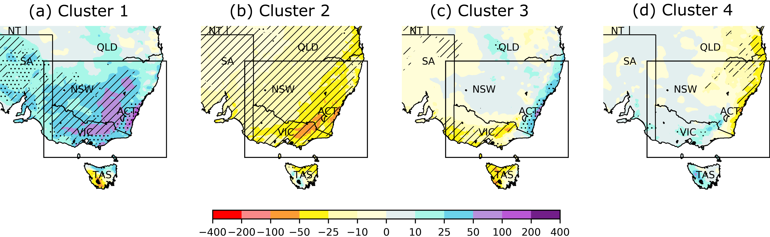
Figure 1. Cluster-mean monthly rainfall anomalies (in mm month-1) in southeastern Australia. The black box shows the region used for clustering the rainfall anomalies. Statistically significant anomalies are dotted. Anomalies that are additionally robust within the cluster are hatched.
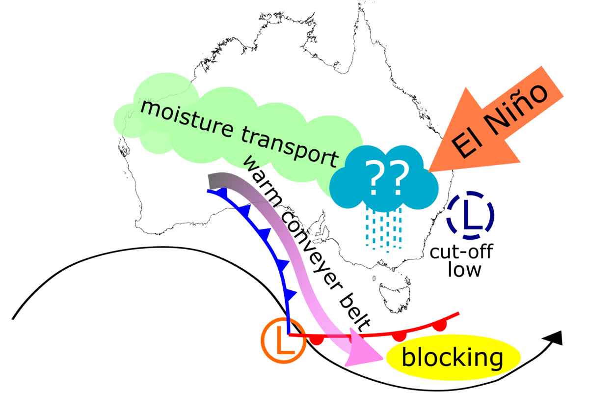
In order to advance the meteorological understanding driving these patterns, objectively identified weather systems are used [2]. The focus is on cut-off lows, extratropical cyclones, atmospheric blocking, moisture transport and warm conveyor belts (WCBs), which represent the main-ascending, precipitating part of extratropical cyclones. During dry El Niño conditions in southeastern Australia, a blocking high pressure system is centred over the southern part of the continent (Fig. 2b). This suppresses the occurrence frequency of rain-bringing WCBs, cut-off lows, and extratropical cyclones. In contrast, composites of the unusually wet Cluster 1 show a high frequency of blocking high pressure systems southeast of Australia and an increased frequency of cut-off lows along the South Coast and WCBs more inland. In addition, enhanced moisture transport from the Tropics across the continent supports rain-bringing WCB activity in southeastern Australia (Fig. 2a). It is the change in frequency of WCBS and cut-off lows that explains the wet conditions but not the change in rainfall intensity.
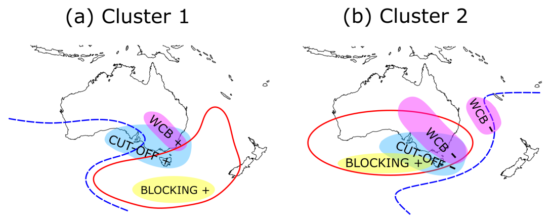
Figure 2: Schematic summary of large-scale flow anomalies and weather system frequency anomalies for wet Cluster 1 (a) and dry Cluster 2 (b) during El Niño. The red solid (blue dashed) line shows the cluster-averaged position of the positive (negative) geopotential anomaly at 500 hPa. Regions with statistically significant and robust frequency anomalies are marked (positive: +, negative: -): cut-off lows (blue), WCBs (pink) and blocking (yellow).
To return to the initial question, wet conditions during El Niño occur in southeastern Australia on monthly time-scales due to changes in the activity of weather systems. The results of this study highlight that these weather systems may override the effect of El Niño which is important when aiming for skilful seasonal forecast in this region.SH & JQ
[1] Hauser, S., C. M. Grams, M. J. Reeder, S. McGregor, A. H. Fink, J. F. Quinting (2020) A weather system perspective on winter-spring rainfall variability in southeastern Australia during El Niño. Quarterly Journal of the Royal Meteorological Society. doi: 10.1002/qj.3808. Accepted.
[2] Sprenger, M., Fragkoulidis, G., Binder, H., Croci-Maspoli, M., Graf, P., Grams, C. M., Knippertz, P., Madonna, E., Schemm, S., Škerlak, B. and Wernli, H. (2017) Global climatologies of Eulerian and Lagrangian flow features based on ERA-Interim. Bulletin of the American Meteorological Society, 98, 1739–1748.
09/01/2020 - Research stay at the University of Tsukuba
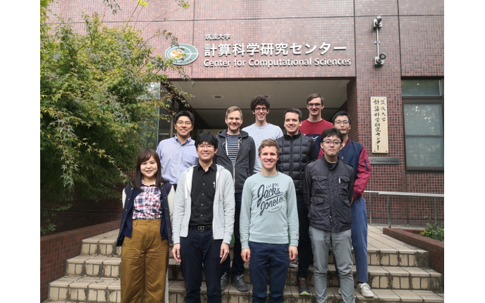
After the successful start of our collaboration with colleagues from the Center for Computational Sciences at the University of Tsukuba (Japan) in May 2019, we spent several weeks at Tsukuba University in November. The collaboration between our groups at the University of Tsukuba and KIT is funded by the DAAD joint research project "Weather regimes in Europe and Asia: sub-seasonal predictability (WEASP)".
Following our discussions in May, we continued to work on two main working packages: 1.) a year-round definition of East Asian weather regimes and 2.) the verification of these regimes in sub-seasonal numerical weather prediction models.
The definition of East-Asian weather regimes turned out to be a challenging task since the occurrence of some regimes is limited to summer or winter. Also, circulation patterns in this region of the world are more transient which requires a different approach than for weather regimes in the Atlantic-European sector. Despite these difficulties, we made huge progress in finding a year-round definition for East-Asian weather regimes. Thanks to in-depth discussions with our Japanese colleagues it was possible to come up with a year-around weather regime definition for East Asia including Siberia. Furthermore, we newly identified year-around weather patterns specifically focusing on weather and its extremes in Japan. These definitions lay the basis for future studies on dynamical processes that influence weather regimes and weather patterns in East Asia.
Concerning the second working package (the verification of East Asian weather regime forecast), we discussed on how to best calibrate forecasts in order to account for systematic model biases. When investigating the flow dependent forecast skill of numerical weather prediction models, typical bias corrections may misleadingly degrade the actual forecast skill. We therefore developed a new calibration techniques which will be useful to elucidate the overall forecast skill of weather regimes in East Asia but also in the Atlantic-European sector.
Besides the meetings with our colleagues at the University of Tsukuba, Christian gave a seminar at the Meteorological Research Institute (MRI) of the Japan Meteorological Agency (JMA) in Tsukuba and visited colleagues at JAMSTEC (Japan Agency for Marine Earth Science and Technology). One of the highlights of our trip was a symposium on climate science at University of Tokyo with Professor Brian Hoskins, Mio Matsueda, Taroh Matsuno and other colleagues from Japan. After the symposium, we took the fast and frequently operating (every 5-10 minutes) Shinkansen train to spend a weekend in Kyoto (the former Japanese capital) where we visited many temples and shrines and enjoyed the Japanese culture. We would like to say arigato gozaimasu (ありがとうございます) (thank you very much) to our colleagues in Japan and look forward to their next visit in February./JW & JQ
18/12/2019 - White Christmas: A challenge for Subseasonal Prediction!?
Christmas 2019 is approaching and people are wondering early in December “What are the odds of a cold, snowy White Christmas?” or “Will it be a warm and windy holiday season as in previous years?” Questions alike are not only of public interest, they are also relevant to various socio-economic activities such as renewable energies or the transportation sector. Episodes of exceptionally warm or cold temperatures, strong or weak winds, or heavy precipitation typically last for several days and affect continent-size regions. Weather on these spatio-temporal scales is governed by weather regimes, which are large-scale circulation patterns in the lowest 10 km of the atmosphere. Further up – in the stratosphere – the circulation during winter is dominated by strong circumpolar westerly winds forming the stratospheric polar vortex (SPV). The intensity of the SPV usually changes gradually within a few weeks, but occasionally the westerly winds break down abruptly, which is called “sudden stratospheric warming” (SSW). Because of the dynamical coupling between the stratosphere and the troposphere below, extreme anomalous states of the SPV can induce persistent surface weather conditions. In particular, SSWs are believed to be followed by cold and calm conditions in Europe.
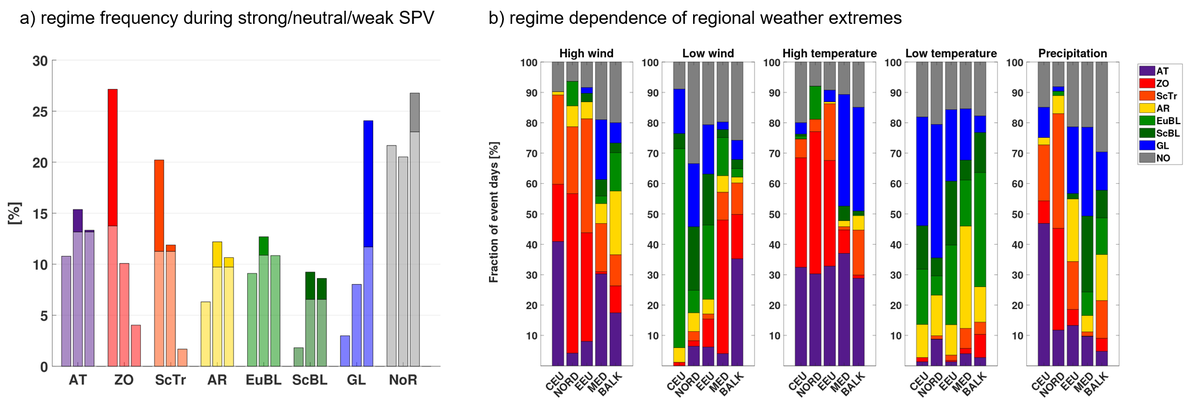
In a recent study [1], we found that not only the most extreme states of the SPV change the odds for specific weather regimes but more generally also above-normal, normal, or below-normal SPV conditions (Figure 1a). Nevertheless, large-scale weather extremes in different European sub-regions, happen during any SPV state. This can be explained by the fact that most large-scale weather extremes occur during more than one preferred weather regime (Figure 1b). Interestingly, a few weather regimes occur irrespective of the SPV state. These regimes thus provide pathways to weather extremes that might be unexpected with respect to the current SPV state. For example, the Atlantic Trough (AT) regime occurs during any SPV state and thus provides a pathway to high wind events in Central Europe also during weak SPV states, while other regimes causing such events (ZO, ScTr) are suppressed.
These findings suggest that numerical weather prediction models require not only a correct stratosphere-troposphere coupling but also a correct representation of weather regimes to fully exploit the potential predictability from the stratosphere. Indeed, the subseasonal forecast issued by ECMWF correctly indicated a dominance of mild and windy regimes (ZO, ScTr, AT) in the first half of December 2019 more than four weeks ahead (Figure 2). These regimes will dominate until Christmas. So at least for Central Europe the chances for White Christmas are low. However, models consistently predict a change of the prevailing regime over the holidays, giving a little hope for belated snow at least for some of us.
Ongoing research in the LSDP group now investigates systematically how the forecast skill for surface weather depends on the SPV state and the correct representation of weather regimes [2] and what determines the specific regime response and associated surface weather following SSW events [3]./ DB & CG & JQ
[1] Beerli, R., and C. M. Grams, 2019: Stratospheric modulation of the large-scale circulation in the Atlantic–European region and its implications for surface weather events. Q.J.R. Meteorol. Soc., 145, 3732–3750, doi:10.1002/qj.3653.
[2] Büeler, D., R. Beerli, H. Wernli, and C. M. Grams, 2020: Stratospheric influence on ECMWF sub-seasonal forecast skill for European energy-industry-relevant surface weather. In preparation for Q.J.R. Meteorol. Soc.
[3] Domeisen, D. I. V., C. M. Grams, and L. Papritz, 2019: The role of North Atlantic-European weather regimes in the surface impact of sudden stratospheric warming events. Weather and Climate Dynamics, submitted.
06/10/2019 - 19th Cyclone Workshop
For the 19th time, scientists from all over the world attended the “Cyclone Workshop”. The workshop is traditionally held every two years in the United States or Canada. Due to the 100th anniversary of the famous Bergen School of Meteorology paper, this year’s workshop took place at the beautiful scenery of the Monastery Seeon from 29 September to 04 October. The intense and exciting program included presentations on the dynamics of weather systems at all spatio-temporal scales, from supercells and tornadoes to cyclone families, atmospheric blocks and large-scale weather regimes. Christian, Dominik, Moritz, Julian and Seraphine attended the workshop and presented their research highlights in posters and talks. In addition to scientific talks and poster presentations, recreational breaks as well as interactive evening sessions helped to establish new contacts in the community. As a follow up of the workshop, Maria Madsen (University of Wisconsin) and Ben Moore (NOAA) will visit the SPREADOUT group to work on future collaborations.
01/08/2019 - Welcome Seraphine Hauser

We welcome back Seraphine Hauser in the group “Large-scale Dynamics and Predictability”. Seraphine studied Meteorology at KIT and always had a strong interest in weather systems. Consequently already in her Bachelor’s thesis she performed a synoptic analysis of a dust storm in spring 2015 over the Arabian Peninsula. For her Master thesis she joined our team and discovered an important impact of weather systems in ENSO related precipitation anomalies for Southeastern Australia. This included an intense collaboration with colleagues in Australia and a three-month research stay at Monash University. Seraphine now starts her PhD research in which she will investigate blocked weather regime life-cycles from a potential vorticity dynamics perspective making extensive use of ERA5-reanalysis data. This research is embedded within the Transregional Collaborative Research Center “Waves2Weather” and in close collaboration with colleagues at University of Mainz and the Young Investigator group “SPREADOUT” at IMK-TRO. Seraphine is based at Campus North temporarily in the Master’s room of IMK-TRO (building 435, office 204, phone: 23174). We wish Seraphine a happy start, a successful PhD time, and a lot of fun working in W2W and at IMK. Welcome! /CG
26/06/2019 - European heat also develops locally
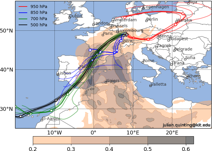
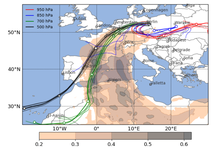
This text is adapted from an official KIT expert’s statement published on 26.6.2019. The original text (in german) written by Timo Schreck is available at http://www.sek.kit.edu/kit_express.php.
Central Europe suffers from the current heat wave. The danger of forest fires and health impacts accompanies such extreme weather. Today, we expect the hottest day of the week with maximum temperatures of up to 40 degree Celsius. Often air masses from the Sahara are said to cause these hot temperatures. Researchers at IMK-TRO now show that this is only half of the story – the near-surface air causing the blazing heat in Central Europe is also produced locally.
„Heat waves are periods of at least three consecutive days with maximum temperature in excess of the top 10% of the hottest days in a season”, explains Andreas Fink from IMK-TRO at KIT. To define these hottest days, mostly a reference period of the last 30 years is considered. However, the current hot near-surface air does not originate from the Sahara but is produced locally, as recent research by Philipp Zschenderlein’s project “Predictability of heat waves in Europe” within the DFG-funded collaborative research center “Waves to Weather” (https://www.wavestoweather.de/) shows: „On the way to southern Germany, the air mass in the lower-levels (up to 2km) descend and warm by so-called adiabatic compression. This process can be imagined like the warming in a bicycle tyre inflator. This time the warming due to descent is unusually high compared to other heat waves.“
Julian Quinting and Christian Grams of the Young Investigator Group “Large-scale Dynamics and Predictiability” at IMK-TRO computed the origin of the current near-surface air mass which reveals that it originates from the Baltic Sea region (Fig. 1). On Saturday, its air temperature was only about 10 degree Celsius, but at a higher altitude. Air from the Sahara still plays a role as the two researchers add: „It conditions the large-scale environment to allow local warming over Europe. In mid-levels of 3-5 kilometres air from North Africa are advected towards Europe and enhance the high pressure system called ‘Ulla’. Numerical weather forecasts indicated the start of this large-scale weather regime characterised by high pressure over Europe and low pressure over the East Atlantic already 10 days ahead of the peak of the heat wave which allowed a very reliable forecast.“
The mid-level air from the Sahara transports unusually high amount of dust, as revealed by novel dust forecasts with the numerical modelling system ICON-ART, run by Heike Vogel in collaboration with the Deutscher Wetterdienst (DWD) (Fig. 1). This also affects the forecast of maximum temperatures, as her colleague and leader of the working group “Aerosols, Trace Gases and Climate Processes”, Bernhard Vogel, adds: „The high amount of dust cause uncertainty in the forecast of maximum temperature. The dust reduces the direct insolation but could also influence the formation of mid- and high-level clouds and thus reduces insolation significantly.” This is an important topic of current research activities at IMK-TRO.
Research on heat waves at KIT is one of the key competences of IMK-TRO. Next to a Young Investigator Group, KIT is also involved in several research projects: The DFG-funded transregional collaborative research centre „Waves to Weather“ (W2W) aims – amongst others – to advance predictability of heat waves. Within the sub-project „The role of multi-scale Dynamical Processes in shaping recent and future extreme Heat waves over Germany (DynProHeat)“ of the BMBF initiative „Climate Change and Extremes“ (ClimXtreme) Andreas Fink and Joaquim Pinto will investigate how climate change will affect heat waves. The project „Solar power reduction due to Saharan dust“ (PerduS) in collaboration with the Deutscher Wetterdienst (DWD) aims to improve forecasts of solar power output during Saharan dust events.
WG Atmospheric Dynamics https://www.imk-tro.kit.edu/english/5874.php
WG Large-scale Dynamics and Predictability http://www.imk-tro.kit.edu/english/7425.php
WG Aerosols, Trace Gases and Climate Processes http://www.imk-tro.kit.edu/english/3487.php
Further reading:
Bieli, M., S. Pfahl, and H. Wernli, 2015: A Lagrangian investigation of hot and cold temperature extremes in Europe. Q.J.R. Meteorol. Soc., 141, 98–108, doi:10.1002/qj.2339 ![]() .
.
Quinting, J. F., and M. J. Reeder, 2017: Southeastern Australian Heat Waves from a Trajectory Viewpoint. Mon. Wea. Rev., 145, 4109–4125, doi:10.1175/MWR-D-17-0165.1 ![]() .
.
Rieger, D., and Coauthors, 2015: ICON–ART 1.0 – a new online-coupled model system from the global to regional scale. Geosci. Model Dev., 8, 1659–1676, doi:https://doi.org/10.5194/gmd-8-1659-2015 ![]() .
.
Schaller, N., J. Sillmann, J. Anstey, E. M. Fischer, C. M. Grams, and S. Russo, 2018: Influence of blocking on Northern European and Western Russian heatwaves in large climate model ensembles. Environ. Res. Lett., 13, 054015, doi:10.1088/1748-9326/aaba55 ![]() .
.
Sprenger, M., and H. Wernli, 2015: The LAGRANTO Lagrangian analysis tool – version 2.0. Geosci. Model Dev., 8, 2569–2586, doi:10.5194/gmd-8-2569-2015 ![]() .
.
Zschenderlein, P., G. Fragkoulidis, A. H. Fink, and V. Wirth, 2018: Large-scale Rossby wave and synoptic-scale dynamic analyses of the unusually late 2016 heatwave over Europe. Weather, 73, 275–283, doi:10.1002/wea.3278 ![]() .
.
14/05/2019 - Successful first research stay of our partners from University of Tsukuba at KIT
During the first week of May, we had the opportunity to welcome our research colleagues from University of Tsukuba (Japan), Mio Matsueda (Assistant Professor), Akio Yamagami (PostDoc), and Takumi Matsunobu (MSc Student), at KIT. Their stay was the kick-off visit in the framework of our two-year DAAD joint research project “Weather regimes in Europe and Asia: subseasonal predictability (WEASP)”, which aims to foster collaboration between our groups at University of Tsukuba and KIT.
The visit entailed numerous fruitful meetings, in which we discussed first results of our common research, exchanged expertise on open challenges, and ultimately defined specific goals and tasks we want to achieve during the upcoming year. More specifically, we advanced the two following main work packages: first, we will come up with a year-round definition of East Asian weather regimes, investigate their dynamical characteristics with a focus on diabatic outflow, and verify their predictability in subseasonal numerical weather models, similarly to what we already do for the Euro-Atlantic weather regimes. Considering the strongly varying and thus fascinating climate of Japan, which ranges from heavy snow falls triggered by the mixing of cold Siberian air masses with humid maritime air masses from the Subtropics to devastating Typhoons that regularly hit the island, this research may ultimately help to improve operational subseasonal forecasting in Japan. To this end, the knowledge of our Japanese colleagues about East Asian climate perfectly complements the dynamical, weather system-oriented expertise about weather regime life cycles at SPREADOUT. In a second work package, we will draw upon the strong technical and statistical expertise of our colleagues to verify the subseasonal predictability of year-round Euro-Atlantic weather regimes, which will be the foundation for many research goals of SPREADOUT. Beside these main topics, we exchanged further ideas related to ongoing work on extreme events in Japan, tropical influences on Japanese climate, and dynamical links between Euro-Atlantic and East Asian weather regimes. The diverse research topics of our guests from Tsukuba was also of interest in a number of side meetings with colleagues at IMK-TRO. As a final scientific highlight, the delegation from Japan presented highlights from their past and ongoing work in the “Karlsruhe Meteorologisches Kolloquium” (the IMK-wide external seminar): Mio presented some of his extensive work on the verification of medium-range predictability of Euro-Atlantic winter weather regimes and introduced the publicly available TIGGE and S2S museums. Akio continued with an overview of his research on the dynamics of extraordinary Arctic Cyclones and Takumi finished with his work on the predictability of a past heavy precipitation event over Japan.
Since this was the first longer visit of Europe for some of our guests, we of course did not want to miss out on introducing them to some of the natural and culinary beauties of Southern Germany. We thus went for a hike in the Black Forest on the sunny 1st of May, visited Heidelberg on a cold Sunday, and ate delicious local food in various restaurants in Karlsruhe, which included tasty asparagus, good beer, and a ride on the legendary slide in the “Badisch Brauhaus”. In return, Mio, Akio and Takumi told us a lot about their certainly different but very interesting culture, about their traditions, and about how science works in their country. After an intense week, we all agreed on the success of their stay and the potential of our collaboration. Therefore, we are excited to continue with our joint research project WEASP and hopefully exchange many new results when we from SPREADOUT will visit them in fall 2019.
For more information about the research of our colleagues, visit the webpage of Mio Matsueda’s group at University of Tsukuba. / DB
29/04/2019 - Spreadout at the S2S/TIGGE workshop at ECMWF in Reading, UK
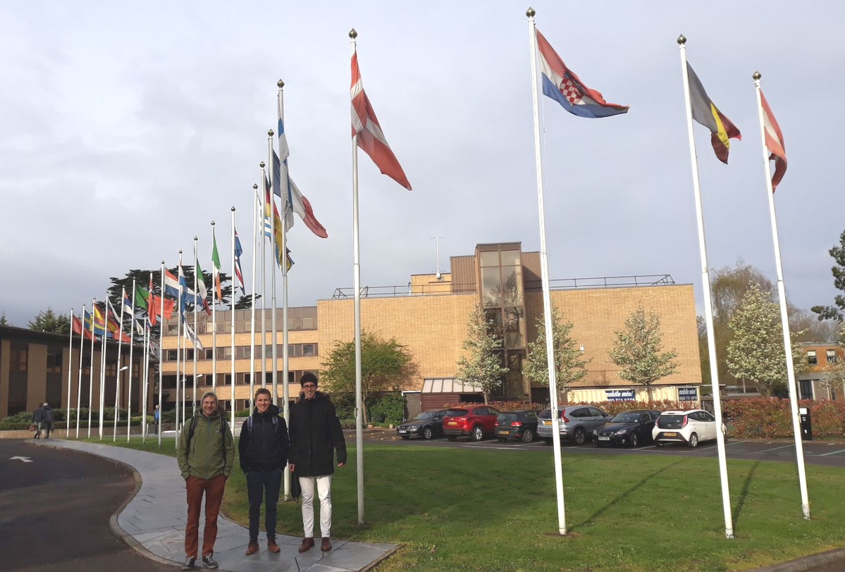
We recently had the opportunity to attend the inspiring and perfectly organized "Workshop on predictability, dynamics and applications using the TIGGE and S2S ensembles" at the European Centre for Medium-Range Weather Forecast (ECMWF) in Reading (UK). The workshop gathered a diverse group of people from research, industry, and national weather services from all over the world who work with the two popular model intercomparison datasets for medium-range (TIGGE) and subseasonal (S2S) weather prediction.
Reading's busy morning traffic does not make it easy for the buses to reach the "Weather Centre", as the friendly Britains like to call it, on time. But with some patience and strengthened by a classic English breakfast, we succeeded and were ready to start the workshop. Jan and Christian both presented our operational weather regime forecast products. They showed their usefulness not only for operational weather forecasting but also for understanding how synoptic-scale processes, such as cloud-condensational heating in midlatitude cyclones, affect the subseasonal predictability of weather regime life cycles. Both contributions triggered lots of discussions with researchers working on large-scale dynamics, colleagues working on numerical model development, and forecasters seeking for better operational tools. Dominik presented an applied research project in cooperation with Remo Beerli (Axpo Solutions AG), which quantifies the skill of the ECMWF subseasonal model in predicting month-ahead, country-averaged surface weather over Europe after particularly strong and weak states of the stratospheric polar vortex during winter. Due to the sudden stratospheric warming at the beginning of this year and the failure of weather models (and thus the energy industry) to correctly predict its impact on surface weather, this contribution gained particular attention from energy meteorologists participating in the workshop, but also from model developers trying to better understand model biases associated with such dynamically complex events.
Numerous interesting contributions highlighted the great potential in using ensemble data for better predictions on subseasonal time scales. However, many studies also documented the lack of forecast skill for the midlatitudes beyond two weeks. It became obvious that models still struggle to fully exploit potential sources of extended range predictability (such as the stratosphere or the MJO). Working group discussions elaborated recommendations to the WMO WWRP/WCRP programs on how to make even better use of the TIGGE and S2S datasets and on the research needed to further improve numerical models. It clearly emerged that there is a need for a better understanding of the processes involved in teleconnections on subseasonal time scales and that the focus for the midlatitudes should be on large-scale regimes. Furthermore, the workshop showed us once more that understanding predictability and improving forecast skill on subseasonal timescales will be one of the key focuses for the coming decade, not just at ECMWF but all around the world. With our process-oriented approach in SPREADOUT to better understand European weather regimes, we are keen to help tackling this challenge!
We ended our week in Reading with an in-depth personal discussion with our collaborators at ECMWF. This was fruitful and very motivating because it once more showed their interest in our research and allowed us to further deepen our plans and specify the next steps in our collaboration.
The recordings of the talks and the posters of the workshop, as well as the working group reports can be found here. More photos of the event are provided here. / DB & CG
23/04/2019 - Highlights in research on extratropical transition
Tropical cyclones (TCs) that move into the midlatitudes undergo a chain of processes that is called “extratropical transition” (ET). Key ideas of SPREADOUT research emerged from our roots in ET research and we are still engaged in this community: In autumn, Julian was rapporteur to the Ninth World Meteorological Organization (WMO) International Workshop on TCs Sub-Topic 4.3 “Extratratropical Transition” (webpage here, report here).
In this blog post we want to highlight recent research highlights on ET in which we were involved. Most importantly, Julian and Christian substantially contributed to a two-part review paper on ET published in Monthly Weather Review (Evans et al. 2017, Keller et al. 2019). Part 2 summarises our understanding on how diabatic outflow modifies the large-scale circulation and causes forecast uncertainty during the extreme case of a TC interacting with the midlatitude jet stream (Keller et al. 2019). Our colleagues at ETH Zurich now documented systematically when and how often ET actually triggers Rossby waves (Riboldi et al. 2018a). They further studied factors that favour an amplification of the wave guide and the eventual evolution of a remote blocking anticyclone (Riboldi et al. 2018b). Such an amplified wave guide is thought to cause high-impact weather in downstream regions. However, until recently it was difficult to quantify the effect of North Atlantic TCs on European high-impact weather. Now a climatological study lead by our colleagues at University of Bern revealed for the first time the conditions under which ET can double the likelihood of extreme precipitation in Europe (Pohorsky et al. 2019 and Uni Bern press release here). Focusing more on the actual transition of the former TC, IMK-research revealed that the interaction with orography can importantly delay ET or even hinder ET (Lentik et al. 2018). More details on the latter study are in this IMK-News highlight (link here). /CG
References:
Evans, C., and Coauthors, 2017: The Extratropical Transition of Tropical Cyclones. Part I: Cyclone Evolution and Direct Impacts. Mon. Wea. Rev., 145, 4317–4344, doi:10.1175/MWR-D-17-0027.1.
Keller, J. H., and Coauthors, 2018: The Extratropical Transition of Tropical Cyclones. Part II: Interaction with the Midlatitude Flow, Downstream Impacts, and Implications for Predictability. Mon. Wea. Rev., 147, 1077–1106, doi:10.1175/MWR-D-17-0329.1.
Lentink, H. S., C. M. Grams, M. Riemer, and S. C. Jones, 2018: The Effects of Orography on the Extratropical Transition of Tropical Cyclones: A Case Study of Typhoon Sinlaku (2008). Mon. Wea. Rev., 146, 4231–4246, doi:10.1175/MWR-D-18-0150.1.
Pohorsky, R., M. Röthlisberger, C. M. Grams, J. Riboldi, and O. Martius, 2019: The Climatological Impact of Recurving North Atlantic Tropical Cyclones on Downstream Extreme Precipitation Events. Mon. Wea. Rev., 147, 1513–1532, doi:10.1175/MWR-D-18-0195.1.
Riboldi, J., M. Röthlisberger, and C. M. Grams, 2018a: Rossby Wave Initiation by Recurving Tropical Cyclones in the Western North Pacific. Mon. Wea. Rev., 146, 1283–1301, doi:10.1175/MWR-D-17-0219.1.
Riboldi, J., C. M. Grams, M. Riemer, and H. M. Archambault, 2018b: A Phase Locking Perspective on Rossby Wave Amplification and Atmospheric Blocking Downstream of Recurving Western North Pacific Tropical Cyclones. Mon. Wea. Rev., 147, 567–589, doi:10.1175/MWR-D-18-0271.1.
18/04/2019 - 3 Months Research Stay at Monash University in Melbourne, Australia

Seraphine Hauser, Master’s student in the Large-scale dynamics and predictability group, spent the last 3 months in Australia to work on her thesis about ‘A weather system perspective on cool-season rainfall variability in southeastern Australia during El Niño’ in the School of Earth, Atmosphere and Environment in Melbourne. Together with her supervisors abroad, Michael Reeder and Shayne McGregor, she discussed her latest results and got inspiration for further investigations. Seraphine’s analysis reveals the importance of midlatitude weather systems for the month-to-month rainfall variability that is observed during El Niño. In particular, the interplay of blocking anticyclones, cut-off systems and warm conveyor belts determines whether southeastern Australia experiences anomalously dry or wet conditions – an important information for the agricultural sector. During her stay in Melbourne, which was supported by the ARC Center of Excellence for Climate System Science, Seraphine also got the chance to visit the Bureau of Meteorology to further expand her expertise on the characteristics of weather and climate in Down Under.
Regarding the last 3 months, Seraphine is very happy about the experiences and exchange with researchers at Monash University and grateful that the final thesis will feature many of Michael’s and Shayne’s suggestions. /SH
20/02/2019 - Welcome Moritz Pickl

We welcome Moritz Pickl in the group “Large-scale Dynamics and Predictability”. Moritz received a Bachelor’s degree in Freiburg and then moved to the University of Berne for a Master’s degree in Climate Sciences with specialization in Atmospheric Sciences. In his thesis he studied the variability of North Atlantic teleconnections and ocean-atmosphere interaction during the last millennium. He continued with a one-year internship at MeteoSwiss where he contributed to the preparation of the Swiss Climate Change Scenarios CH2018.
Moritz now starts a PhD in which he will investigate the sensitivity of diabatic outflow and its impact on the large-scale circulation with numerical experiments in ICON and with data from the IFS ensemble. This will be an important component of the project “SPREADOUT” and inform us if the correct representation of diabatic outflow is critical during weather regime life cycle stages. Moritz is based at Campus North (435, office 316a). We wish Moritz a great start, success and a lot of fun with his work and colleagues at IMK. Welcome! / CG
13/01/2019 - Representation of synoptic‐scale Rossby Wave Packets and Blocking in the S2S Prediction Project Database
Equatorward and poleward wind perturbations propagating eastward along the fast flowing air currents in midlatitudes are commonly referred to as Rossby wave packets (RWPs). Typically, the waves form in the entrance region of the midlatitude storm tracks, that is, over the western North Pacific and the western North Atlantic. Regions of RWP decay are the exit regions of the storm tracks over North America and the East Atlantic/European region.
The occurrence of RWPs has been linked to extreme weather events such as intense winter storms, heat waves, and heavy precipitation. Hence, an adequate representation of RWPs in state‐of‐the‐art numerical weather prediction models is desirable to better predict these weather extremes.
In a recent study [1], we now verify for the first time the representation of RWPs in a set of 11 numerical weather prediction models on time‐scales of up to 28 days. It is shown that fundamental properties such as their climatological frequency of occurrence, their life time, and their mean propagation distance are represented reasonably well. However, models ‐ especially those with a rather coarse horizontal grid spacing ‐ struggle to adequately represent the frequency of decay of these waves in the exit region of the storm tracks over the Atlantic/European sector. Instead of decaying over the eastern North Atlantic, RWPs propagate into far eastern Europe likely due to an underestimation of the occurrence frequency of long‐lasting and stationary high pressure systems – commonly referred to as blocking highs. The observed systematic errors in the frequency of blocking highs and in the RWP decay is most pronounced but not unique to models with coarse resolution. That the observed errors are not purely resolution dependent points to the effect of the different representation of key physical processes for RWP dynamics in models of the S2S database. To pinpoint these processes with process-oriented diagnostics is one goal of the Large-scale dynamics and predictability group./JQ
[1] Quinting, J.F., and F. Vitart, Representation of synoptic‐scale Rossby Wave Packets and Blocking in the S2S Prediction Project Database, Geophys. Res. Lett., 46. https://doi.org/10.1029/2018GL081381 (2019).
17/10/2018 - Process-oriented Understanding of weather forecast error
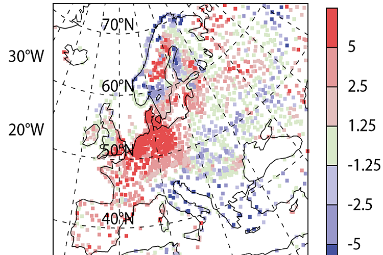
Despite huge progress made in numerical weather prediction, occasionally severe forecast errors occur affecting large regions. In Europe, such “forecast busts” are related to a misforecast of the large-scale circulation over the Atlantic-European region. An example on how this affects 2m temperature forecast over Europe is shown in Figure 1. In this six-day forecast issued on 07 March 2016, the model predicts too mild conditions for wide parts of western and Central Europe whereas it predicts too cold conditions in Italy and the Balkans (Figure 1; note that data from more weather stations is available in central Europe and thus the density of available surface observations is much higher there).
The March 2016 forecast bust was related to the onset of a stationary high pressure system over the North Sea region – a so-called European blocking regime. Such weather regimes typically last for several days to a few weeks and affect entire Europe. Thus, it is important to understand why numerical models struggle in correctly predicting their life cycles.
In a recently published study [1], we now reveal that condensational processes associated with the warm conveyer belt (WCB) of an extratropical cyclone effectively amplify a small error early in a weather forecast and projects it on the large-scale circulation resulting in the severe forecast bust for entire Europe for the later forecast hours.
The group now investigates if this is a singular case or if WCBs and other processes acting on weather time scales generally dilute forecast skill for the large-scale weather regimes on medium-range to subseasonal time scales (10-30 days). Therefore, we investigate dynamical processes driving weather regime life cycles using reanalysis and historical weather forecast data. This includes the investigation of how slower climate modes such as the stratosphere, the ocean state, or the Madden-Julian-Oscillation affect predictability of weather regimes [2] and how weather regimes modulate surface weather on subseasonal time scales [2, 3].
The group is funded by the Helmholtz Association with a Helmholtz Young Investigator Group Grant for the project “Subseasonal Predictability: Understanding the Role of Diabatic Outflow” (SPREADOUT). /CG.
[1] C. M. Grams, L. Magnusson, and E. Madonna, An atmospheric dynamics‘ perspective on the amplification and propagation of forecast error in numerical weather prediction models: a case study. Quarterly Journal of the Royal Meteorological Society, in press, doi:10.1002/qj.3353 (2018).
[2] C. M. Grams, R. Beerli, S. Pfenninger, I. Staffell, H. Wernli, Balancing Europe’s wind-power output through spatial deployment informed by weather regimes. Nature Climate Change. 7, 557–562, doi:10.1038/NCLIMATE3338 (2017).
[3] L. Papritz, C. M. Grams, Linking Low‐Frequency Large‐Scale Circulation Patterns to Cold Air Outbreak Formation in the Northeastern North Atlantic. Geophysical Research Letters. 45, 2542–2553, doi:10.1002/2017GL076921 (2018).
12/10/2018 - Spreadout at the WWRP/WCRP S2S and S2D conference in Boulder, CO
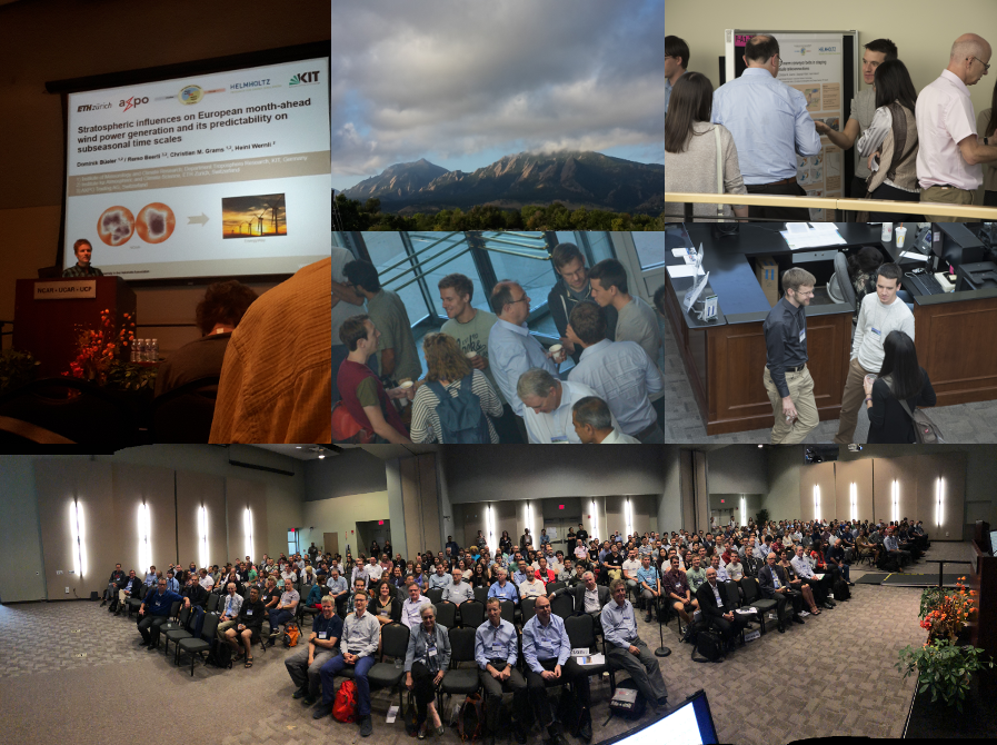
The conference aimed to foster the exchange of information between the S2S and S2D communities, to identify challenges for transferring S2S and S2D research into operations, and to identify new collaborations, initiatives and urgent science issues (https://www.wcrp-climate.org/s2s-s2d-2018-home). Our contributions covered various of the conference themes: Dominik presented his applied research with Remo Beerli on the importance of the wintertime stratospheric polar vortex in serving as a predictor of month-ahead wind electricity generation in Europe. Julian’s and Christian’s contributions focused on current science issues. Christian pointed out that diabatic processes within rapidly ascending midlatitude airstreams (warm conveyor belts - WCBs) contribute to the formation and maintenance of blocked weather regimes. Julian then stressed in one of his contributions that subseasonal numerical weather prediction models generally underestimate the occurrence of stationary anticyclones (blocking) over the Atlantic-European region. This may be due to an inadequate representation of diabatic processes – a hypothesis which we now study in further detail. Our research combining process understanding and applications received quite positive feedback. Motivated by fruitful and very inspiring discussions with the S2S community, we now continue to identify processes acting on weather time scales that might dilute forecast skill on subseasonal time scales. /JQ.
18/07/2018 - Welcome Jan Wandel
We are very happy to welcome Jan Wandel as a student assistant in our group. Jan got a Bachelor’s and Master’s degree in Meteorology from KIT. During his studies he was engaged in IMK’s “early weather hazards warning” (Wettergefahrenfrühwarnung). In his Masterthesis at IMK-TRO Jan studied the synoptic environment triggering hailstorms in Europe.
Jan will now take care of operational weather regime forecast products in our group and investigate the linkage of weather regimes and hailstorms in collaboration with his former group. Jan will also develop operational forecast products for weather regimes on sub-seasonal time-scales. We wish Jan a great start, success and a lot of fun with his work and colleagues at IMK. Welcome!
Improving weather forecasts on sub-seasonal time scales

Advances in numerical weather prediction currently push the weather forecast horizon into sub-seasonal time scales of several days to a few weeks. On these time scales so-called weather regimes – quasi-stationary, recurrent, and persistent flow patterns – govern the variability of the large-scale circulation. They modulate the character of daily weather for continent-size regions and prolonged periods. Therefore, weather regimes have strong implications for socio-economic sectors such as agriculture, transport, or renewable energies [1].
The correct prediction of weather regime life cycles still is a key challenge for current sub-seasonal forecasting systems because weather regimes are concurrently modified by processes on very different spatial and temporal scales: From a weather perspective, the life cycles of these regimes are influenced by meso- to synoptic-scale weather systems such as extratropical cyclones or convective systems. From a climate perspective, modes of the climate system such as the Madden-Julian-Oscillation or the state of the stratosphere are potential sources of sub-seasonal predictability for such regimes.
The newly established group “Large-scale Dynamics and Predictability” aims to provide a comprehensive investigation of the physical and dynamical processes that control predictability and forecast skill on sub-seasonal time scales, with a focus on the life cycle of large-scale flow regimes in the Atlantic-European region. In addition, the group explores novel probabilistic forecast products on sub-seasonal time scales in collaboration with official weather services.
An example of such a novel forecast product is shown for the “early heat wave” in Central Europe that peaked from 19. – 22. April 2018 (Figure 2). The overview regime plot indicates how likely a specific weather regime occurs within the subsequent 15 days (Figure 2a). The detailed regime product shows how well the different regimes are established in a probabilistic forecast (Figure 2b). In this case these forecast products correctly indicated – more than one week in advance – the actual transition from a “Scandinavian blocking regime” (ScBL) into a “zonal regime” (ZO) at the end of the heat wave (Figure 2c compared to Figure 2b). However, particularly such transitions from one regime to another are often not well predicted by current sub-seasonal forecast systems.
The group now investigates in detail how well sub-seasonal forecasting systems represent weather regime life cycles and their underlying physical processes on shorter synoptic time-scales as well as their modulation by slower climate modes, e.g. the Madden-Julian-Oscillation or the state of the stratosphere [2]. Working at the interface of these different spatial and temporal scales will not just improve the understanding of weather regimes but ultimately also contribute to the overarching goal of a seamless prediction of weather and climate.
The group is funded by the Helmholtz Association with a Helmholtz Young Investigator Group Grant for the project “Sub-seasonal Predictability: Understanding the Role of Diabatic Outflow” (SPREADOUT).
Link: Group „Large-scale Dynamics and Predictability“ http://www.imk-tro.kit.edu/english/7425.php
[1] C. M. Grams, R. Beerli, S. Pfenninger, I. Staffell, H. Wernli, Balancing Europe’s wind-power output through spatial deployment informed by weather regimes. Nature Climate Change. 7, 557–562, doi:10.1038/NCLIMATE3338 (2017).
[2] Papritz L., Grams C. M., Linking Low‐Frequency Large‐Scale Circulation Patterns to Cold Air Outbreak Formation in the Northeastern North Atlantic. Geophysical Research Letters. 45, 2542–2553, doi:10.1002/2017GL076921 (2018).
| Fig. 2: Example of novel weather regime forecast products. (a) Ensemble forecast initialised at 12 UTC 15 April 2018. Bars indicate relative number of members projecting in one of 7 weather regimes (colors) or no regime (grey). Bottom rows show the attribution of the ensemble mean, control, and high resolution (up to 240h) forecasts, respectively. (b) Ensemble distribution of projection in one of 7 weather regimes at each forecast step. Light shades indicate maximum and minimum projection, dark shades show the 75th and 25th percentile. Lines show the projection of the control forecast (bold solid), high resolution forecast (bold dashed, only up to 240h), and ensemble mean (thin dashed). (c) Actual verifying projection into 7 weather regimes in the 30day period starting on 7 April 2018. |
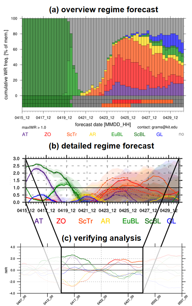
11/06/2018 - Visit of AXPO Trading
The SPREADOUT group visited AXPO Trading in Baden (Switzerland) on 11 June 2018. The main purpose of the visit was to inform energy traders and meteorologists at AXPO about current research activities and to discuss forecast tools useful to the energy sector. After an introductory presentation on SPREADOUT by Christian Grams and Dominik Büeler, Remo Beerli (energy meteorologist at AXPO) showed us the trading floor. There we gained interesting insights in the day-to-day business of energy meteorologists and learned about the forecast products that are needed to provide reliable information to the energy traders. Future collaborations and research avenues were elaborated in a lively discussion in the afternoon.
01/06/2018 - Welcome Nadine Schittko and Seraphine Hauser
SPREADOUT is growing further: We welcome Nadine Schittko and Seraphine Hauser who will join the group for the next year to complete their Master’s degree.
Nadine will analyse the representation of tropical cyclones in the global forecast model ICON. In the framework of the Master’s thesis, she will implement different tropical cyclone tracking algorithms to verify the intensity and motion of tropical cyclones against best track data. Some impact relevant North Atlantic Hurriances in 2016/17 will be studied in greater detail. The project is executed in close collaboration with DWD where the resulting tools may be used operationally in the future for verification purposes.
In her Master’s thesis, Seraphine is going to analyse “The effect of the El Nino Southern Oscillation on Australian climate variability from a weather system perspective”. Using a novel data set of objectively identified weather systems, the goal of the first part of the project is to develop a conceptual picture on how different states of the El Nino Southern Oscillation are related to the occurrence frequency of subtropical and midlatitude weather systems. The results will then be used to attribute the observed variability in temperature and precipitation to these weather systems.
We wish Nadine and Seraphine great success and a lot of fun with their work!
01/03/2018 - Welcome
We welcome Dominik Büeler as a new member of the group “Large-scale Dynamics and Predictability”. Dominik received his PhD from ETH Zurich for his thesis entitled "Potential vorticity diagnostics to quantify effects of latent heating in extratropical cyclones: methodology and application to idealized climate change simulations". Already before his PhD, Dominik gained experience both in climate and weather modelling: he analysed marine boundary layer clouds in ECHAM5-HAM and investigated the northern mid- and high-latitude climate in a climate change mitigation scenario in his Bachelor and Master thesis, respectively. During a one-year internship at MeteoSwiss, he worked on the potential of COSMO in predicting photovoltaic power, which offered him an insight into applied weather science. After a short PostDoc project at ETH Zurich last autumn on month-ahead predictability of European wind power, Dominik will continue research in the field of sub-seasonal predictability at KIT in the project “SPREADOUT”. He will study the representation of large-scale weather regimes in sub-seasonal numerical weather prediction models and physical processes governing weather regime life cycles. We wish Dominik a great start, success and a lot of fun with his work and colleagues at IMK.
15/02/2018 - Welcome
We welcome Julian Quinting as a senior scientist in the group “Large-scale Dynamics and Predictability”. Julian received his PhD from KIT for his thesis entitled “ The impact of tropical convection on the dynamics and predictability of midlatitude Rossby waves: a climatological study” His Diploma and PhD research was part of the PANDOWAE research unit. After his PostDoc time at ETH Zurich and Monash University, Melbourne, Julian is back at KIT and will work on Sub-seasonal predictability in the project “SPREADOUT”.
As a PostDoc in Zurich, Julian worked on upper-level frontogenesis, Rossby wave dynamics, and MJO teleconnections. In addition, he helped preparing the NAWDEX field campaign and in autumn 2016 contributed actively to flight planning and forecasting based in Iceland. His research focus during the last 2 years at Monash shifted to the understanding of physical processes driving extreme events in the Australian region (e.g. heat waves) and southern hemispheric Rossby wave dynamics. In SPREADOUT Julian will study the representation of physical processes in global NWP data sets, their modulation by global teleconnections (e.g. MJO, ENSO), and how they affect sub-seasonal predictability for Europe. We wish Julian great success and a lot of fun with his work and colleagues at IMK.
12/12/2017 - Statement regarding Nature Geoscience manuscript “Southward shift of the global wind energy resource under high carbon dioxide emissions”
Based on an ensemble of 10 global climate model simulations following the RCP4.5 and RCP8.5 scenarios, this study reports a strong decrease of potential wind electricity generation in the mid-latitudes during the XXI Century (https://www.nature.com/articles/s41561-017-0029-9). The authors use a simple methodology and data with low spatio-temporal resolution, and consider an exemplary wind energy turbine for the computations. Compared to other regions of the world (notably North America), the changes for Europe are comparatively small. These projections for Europe are partially in agreement with studies based on datasets with much higher spatial and temporal resolution (e.g., Tobin et al., 2015, Reyers et al., 2016, Moemken et al., 2018). These studies reveal rather small changes of wind energy potentials for Europe on the continental scale (+/- 5%). On the other hand, they point to increased variability of wind electricity generation in multiple time scales. The differences to the Nature Geoscience study are related with the different data resolution and methodology.
In particular, an increased occurrence of low wind speed (< 3m/s) events reported in Moemken et al. (2018) may cause challenges for the energy supply across Europe. However, this challenge can be overcome with suitable mitigation strategies and updated planning. For example, Grams et al. (2017) provide evidence that the concentration of wind parks in some areas (e.g. North Sea) is problematic to warrant a reliable wind electricity generation. A pan-European management strategy and a more de-central distribution of wind parks would permit to balance the weather and climate variability and thus contribute to a more reliable energy supply. Moreover, the joint management of different renewable sources (notably solar) would further contribute to mitigate the possible changes in wind energy production in future decades.
References:
Grams, C. M., R. Beerli, S. Pfenninger, I. Staffell, and H. Wernli, 2017: Balancing Europe’s wind-power output through spatial deployment informed by weather regimes. Nature Climate Change, 7, 557–562, doi:10.1038/nclimate3338.
Moemken, J., M. Reyers, H. Feldmann, and J. G. Pinto, 2018: Wind speed and wind energy potentials in EURO-CORDEX ensemble simulations: evaluation and future changes, Journal of Geophysical Research: Atmospheres, in revision.
Reyers, M., J. Moemken, and J. G. Pinto, 2016: Future changes of wind energy potentials over Europe in a large CMIP5 multi-model ensemble. Int. J. Climatol., 36, 783–796, doi:10.1002/joc.4382.
Tobin, I., and Coauthors, 2015: Assessing climate change impacts on European wind energy from ENSEMBLES high-resolution climate projections. Climatic Change, 128, 99–112, doi:10.1007/s10584-014-1291-0.
Link: http://www.sek.kit.edu/kit_express_3874.php
Contact: Joaquim G. Pinto http://www.imk-tro.kit.edu/14_7131.php
Contact: Christian M. Grams http://www.imk-tro.kit.edu/14_7356.php