Are mountain ranges important for extratropical transition?
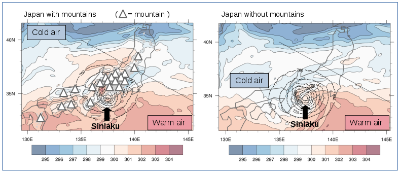
Figure: Potential temperature (K, shaded) and geopotential height (up to 760 m, dashed contours) at 925hPa at 19 September 2008, 12 UTC for the simulation with (left) and without (right) mountains. The gray contours represent coastlines, gray areas and triangles represent orography.
Tropical cyclones (TCs), also called Hurricanes or Typhoons, are one of the most hazardous natural phenomena on Earth. When TCs move towards land, they often receive special attention from the media because of their destructive wind speeds, excessive rainfall and associated storm surge. Thus, they are a thread to human activity, especially in the densely populated coastal areas. Sometimes, a TC moves poleward out of the tropics and into the mid-latitudes. When a TC moves into the mid-latitudes, it experiences a decrease in sea surface temperature, an increase in vertical wind shear near the polar jet stream and it impinges on a horizontal temperature gradient. Due to these environmental changes, the characteristics of the cyclone shift from a typically tropical structure (e.g. axi-symmetric, dominated by deep convection) to a typically extratropical structure (e.g. asymmetric, frontal activity). This transformation is called extratropical transition (ET) [1] [2]. The local and downstream weather during ET is often not well forecasted and the combination of high impact weather and low predictability forms a risk for society. Therefore, ET is one of the topics studied at IMK-TRO.
Most of the ET events occur over the ocean but some TCs recurve and undergo ET along coastal regions like Japan, New Zealand or the United States East Coast. For example, Typhoon Sinlaku (2008) underwent ET along the southern coast of Japan. In order to investigate the influence of orography on the development of the cyclone, Typhoon Sinlaku was simulated with a numerical weather prediction model, both with and without mountains over Japan [3]. For the simulations the COSMO model is used with a high horizontal resolution (2.8 km). In general, orography behaves like a barrier and thus blocks the lower-level air flow. Air parcels either need to flow over or around the barrier. In the COSMO simulation with mountains, the low-level mid-latitude air north of Japan is forced to flow around the orography and does not interact with Sinlaku yet (Fig. 1, left). Once Sinlaku moves further eastward away from the orographic barrier, the cooler air flows southward and ET starts. However, without orography, cool air from the north can immediately interact with Sinlaku, starting the transition from a tropical into an extratropical cyclone (Fig. 1, right). Thus, ET is delayed in the presence of orography. This gives a new insight into the complex interaction when a TC undergoes ET near land and orography.
[1] Evans, C., and Coauthors, 2017: The extratropical transition of tropical cyclones. Part I: Cyclone evolution and direct impacts. Monthly weather review, 145, 4317–4344, https://doi.org/10.1175/MWR-D-17-0027.1
[2] Keller, J. H., and Coauthors, 2019: The Extratropical Transition of Tropical Cyclones Part II: Interaction with the midlatitude flow, downstream impacts, and implications for predictability. Monthly weather review (in press). https://doi.org/10.1175/MWR-D-17-0329.1
[3] Lentink, H. S., Grams, C. M., Riemer, M., Jones, S. C, 2018: The effects of orography on the extratropical transition of tropical cyclones: a case study of Typhoon Sinlaku (2008). Monthly weather review, 146, 4231–4246. https://doi.org/10.1175/MWR-D-18-0150.1
[Working Group: Regional Climate and Weather Hazards]

