
White Christmas: A challenge for Subseasonal Prediction!?
Christmas 2019 is approaching and people are wondering early in December “What are the odds of a cold, snowy White Christmas?” or “Will it be a warm and windy holiday season as in previous years?” Questions alike are not only of public interest, they are also relevant to various socio-economic activities such as renewable energies or the transportation sector. Episodes of exceptionally warm or cold temperatures, strong or weak winds, or heavy precipitation typically last for several days and affect continent-size regions.
|
Weather on these spatio-temporal scales is governed by weather regimes, which are large-scale circulation patterns in the lowest 10 km of the atmosphere. Further up – in the stratosphere – the circulation during winter is dominated by strong circumpolar westerly winds forming the stratospheric polar vortex (SPV). The intensity of the SPV usually changes gradually within a few weeks, but occasionally the westerly winds break down abruptly, which is called “sudden stratospheric warming” (SSW). Because of the dynamical coupling between the stratosphere and the troposphere below, extreme anomalous states of the SPV can induce persistent surface weather conditions. In particular, SSWs are believed to be followed by cold and calm conditions in Europe.
|
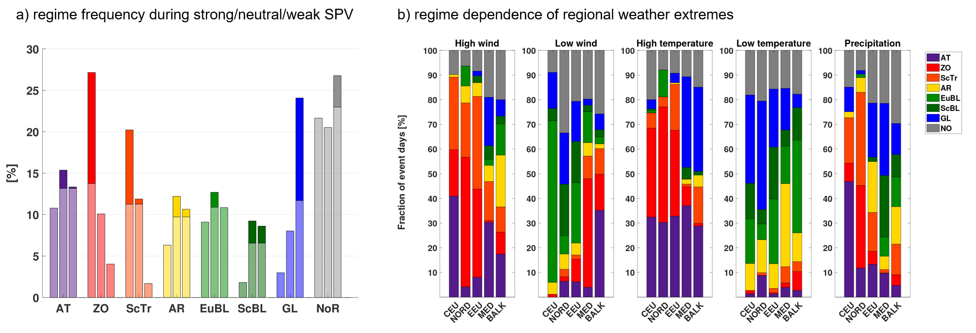
In a recent study [1], we found that not only the most extreme states of the SPV change the odds for specific weather regimes but more generally also above-normal, normal, or below-normal SPV conditions (Figure 1a). Nevertheless, large-scale weather extremes in different European sub-regions, happen during any SPV state. This can be explained by the fact that most large-scale weather extremes occur during more than one preferred weather regime (Figure 1b). Interestingly, a few weather regimes occur irrespective of the SPV state. These regimes thus provide pathways to weather extremes that might be unexpected with respect to the current SPV state. For example, the Atlantic Trough (AT) regime occurs during any SPV state and thus provides a pathway to high wind events in Central Europe also during weak SPV states, while other regimes causing such events (ZO, ScTr) are suppressed.
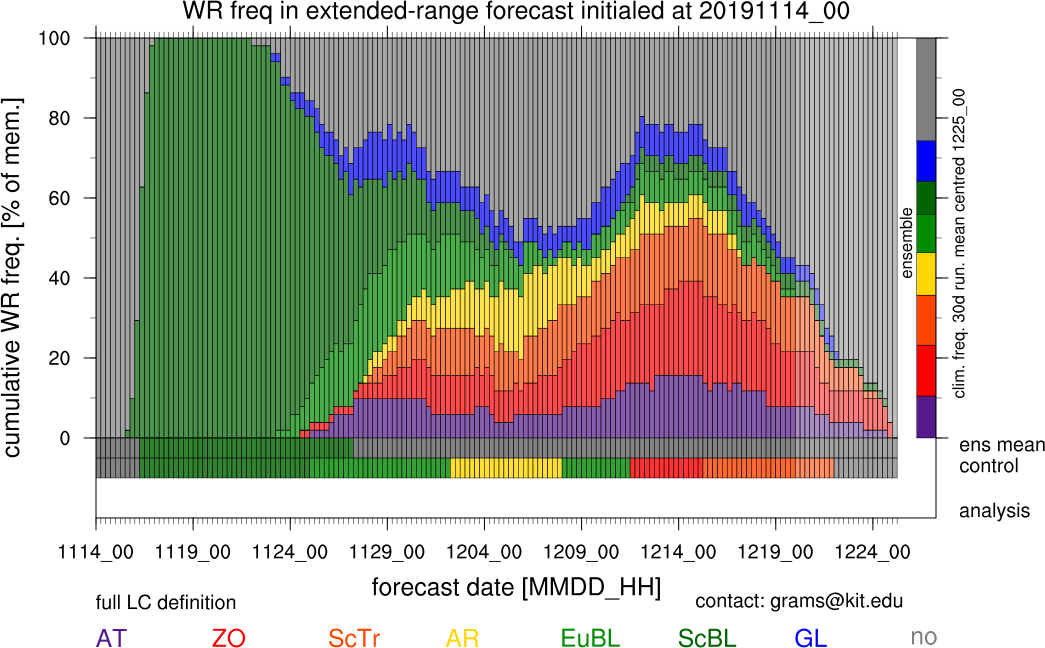
These findings suggest that numerical weather prediction models require not only a correct stratosphere-troposphere coupling but also a correct representation of weather regimes to fully exploit the potential predictability from the stratosphere. Indeed, the subseasonal forecast issued by ECMWF correctly indicated a dominance of mild and windy regimes (ZO, ScTr, AT) in the first half of December 2019 more than four weeks ahead (Figure 2). These regimes will dominate until Christmas. So at least for Central Europe the chances for White Christmas are low. However, models consistently predict a change of the prevailing regime over the holidays, giving a little hope for belated snow at least for some of us.
Ongoing research in the LSDP group now investigates systematically how the forecast skill for surface weather depends on the SPV state and the correct representation of weather regimes [2] and what determines the specific regime response and associated surface weather following SSW events [3].
Link: Group: Large-scale Dynamics and Predictability http://www.imk-tro.kit.edu/english/7425.php
Authors: Dominik Büeler, Christian M. Grams, Julian F. Quinting
Date: 18 December 2019
[1] Beerli, R., and C. M. Grams, 2019: Stratospheric modulation of the large-scale circulation in the Atlantic–European region and its implications for surface weather events. Q.J.R. Meteorol. Soc., 145, 3732–3750, doi:10.1002/qj.3653.
[2] Büeler, D., R. Beerli, H. Wernli, and C. M. Grams, 2020: Stratospheric influence on ECMWF sub-seasonal forecast skill for European energy-industry-relevant surface weather. In preparation for Q.J.R. Meteorol. Soc..
[3] Domeisen, D. I. V., C. M. Grams, and L. Papritz, 2019: The role of North Atlantic-European weather regimes in the surface impact of sudden stratospheric warming events. Weather and Climate Dynamics Discussions, submitted.