
Hail risk SV Sparkassenversicherung (HARIS-SV)
- Contact:
Prof. Dr. M. Kunz
- Project Group: IMK-TRO
- Funding: SV SparkassenVersicherung AG, Stuttgart
- Partner: Center for Disaster Management and Risk Reduction Technology (CEDIM)
Introduction
In the past decade severe hail damage in southern Germany, Austria and Switzerland has increased considerably and has become one of the natural hazards with the highest annual amount of loss. Hailstorms in 2013 in Germany led to an insured loss of almost 3 billion Euro.
The spatial extent of the hail tracks and, consequently, the damaged areas, are strongly limited, with widths from a few 10 m to several 10 km. This local boundary makes the systematic recording of hail storms as well as their statistical evaluation harder. First analyses by IMK about the regional probability of occurrence show considerable differences that occur due to large scale climate conditions as well as to local scale influences from the orthography.
Identifiying hail tracks and estimating hail probability
In cooperation with the SV SparkassenVersicherung AG the first part of the project HARIS-SV (Hail risk SV Sparkassenversicherung) examined the spatial and temporal variability of hail thunderstorms in Germany and an extensive climatology about the occurrence of hail storms in the years 2005 to 2011 was compiled.
Due to their low spatial extent and their short lifespan, hail storms cannot be detected with a high resolution using conventional measure of observation, such as reports from weather stations or individual observations. Therefore, area-covering two- and three-dimensional radar data with high temporal and spatial resolution from the radar network of the German Meteorological Service were used for the examination. First, the data had to undergo broad corrections to eliminate errors and inaccuracies.
Additonally a combination with lightning data was implemented in order to eliminate scattered interference echos. For the corrected radar-data sets that, for Germany, are available starting the year 2005, specific methods to identify hail were developed and tested. Information whether hail actually occurred on the ground was deducted from loss data provided by building and agriculture insurance companies. Subsequently a statistic based on the available meteorological measurement data was conducted about the number and intensity of hail thunderstorms in Germany with a high spatial resolution of 1x1km² (Figure 1).
Beside the mere statistical examination of the spatial and temporal occurrence of hail, an examination about the relation with meteorological conditions such as the associated weather patterns and convection potential was conducted. Additionally the influence of orography on the regional probability of occurrence was examined. A regionally varying dependency of the results on season, and orographic and atmospheric preconditions was found.
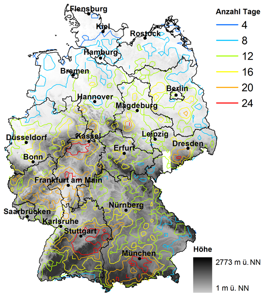
Figure 1: Number of days (2005-2011), on which the hail-criterion (vertical extension between 0°C and a specific radar reflectivity >3,5km) was reached. (Puskeiker, 2013).
Modell for hail losses for Germany
In the second part of the project HARIS-SCM (hail risk damage modeling) the damage effect of hail hitting for individual federal states was determined in more detail. In order to do so, a hail model based on the catalogue of historical hail events from the first part of the project was developed that is able to match the loss data with the hail parameters deducted from the radar data.
Using the insurance inventory data as a basis, total damage of individual severe events as well as expected damage for specific probabilities (return periods) can be estimated using the damage function. It is important to consider factors such as damage effect of hail stones on objects, distribution of the size of hail stones within a thunderstorm as well as the hail track in combination with the location of building roofs, in the model.
Cooperations
SV Sparkassenversicherung, Stuttgart
Vereinigte Hagelversicherung, Gießen
Willis Research Network (WRN), London
Blitz Informationsdienst von Siemens (BLIDS)
Center for Disaster Management and Risk Reduction Technology (CEDIM)
Publications
Brombach, J. (2012): Modifikation der Strömung über Mittelgebirgen und die Auswirkungen auf die räumliche Verteilung hochreichender Konvektion. Diplomarbeit, Institut für Meteorologie und Klimaforschung (IMK-TRO), KIT, 90 S.
Damian, T., 2010: Blitzdichte im Zusammenhang mit Hagelereignissen in Deutschland und Baden-Württemberg. Seminararbeit, Institut für Meteorologie und Klimaforschung (IMK), KIT, 69 S.
Gölz, I., 2011: Analyse der vorkonvektiven Strömungsbedingungen an Hagelschadentagen über Süddeutschland. Seminararbeit, Institut für Meteorologie und Klimaforschung (IMK), KIT, 59 S.
Kugel, P., 2010: Analyse der räumlichen und zeitlichen Entwicklung von Hagelgewittern. Seminararbeit, Institut für Meteorologie und Klimaforschung (IMK), KIT.
Kugel, P. (2012): Analyse der dreidimensionalen Struktur der Radarreflektivität während Hagelereignissen in Baden-Württemberg. Diplomarbeit, Institut für Meteorologie und Klimaforschung (IMK-TRO), KIT.
Kunz, M., und M. Puskeiler, 2010: High-resolution assessment of the hail hazard over complex terrain from radar and insurance data. Meteor. Z., 19, 427-439, DOI:10.1127/0941-2948/2010/0452.
Kunz, M., and P. I. S. Kugel, 2015: Detection of hail signatures from single-polarization C-band radar reflectivity. Atmos. Res, 2015, 153, 565-577.
Puskeiler, M., 2009: Analyse der Hagelgefährdung durch Kombination von Radardaten und Schadendaten für Südwestdeutschland. Diplomarbeit, Institut für Meteorologie und Klimaforschung (IMK-TRO), KIT, 107 S.
Puskeiler, M. (2013): Radarbasierte Analyse der Hagelgefährdung in Deutschland. Wiss. Berichte d. Instituts für Meteorologie und Klimaforschung des Karlsruher Instituts für Technologie Band 59, Karlsruhe, Germany, 202 S.
Puskeiler, M., M. Kunz and M. Schmidberger (2016): Hail statistics for Germany derived from single-polarization radar data. Atmos. Res., 178-179, 459-470.