
New insights into the last glacial permafrost distribution in France
Permafrost is an important component of the climate system and is particularly sensitive to variations in climate. In recent decades, thawing of permafrost soils has affected many high-latitude regions, and thawing is most likely to accelerate in the near- and long-term future. While enhanced greenhouse gas forcing leads to rising temperatures and, thus, to permafrost thawing, the thawing itself leads to the release of greenhouse gases that were previously bound within the frozen soils. Therefore, the greenhouse effect is enhanced and leads to further warming of the climate in a positive feedback [1].
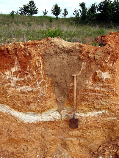
Current global climate model simulations project a large range of uncertainties regarding the decrease in permafrost areas. The models are calibrated for present-day conditions, under which they are well-tested. However, the responses of the models to the same forcing vary by several orders of magnitude [1]. In this context, simulations of past climates and comparison of the results with proxy evidence provide a unique opportunity to evaluate the climate models under a wider range of climate conditions. In the case of permafrost, proxies are, for example, sand-wedge casts and ice-wedge pseudomorphs. They develop within multi-year frozen ground when temperatures drop quickly and the ground experiences thermal contraction cracking [2].
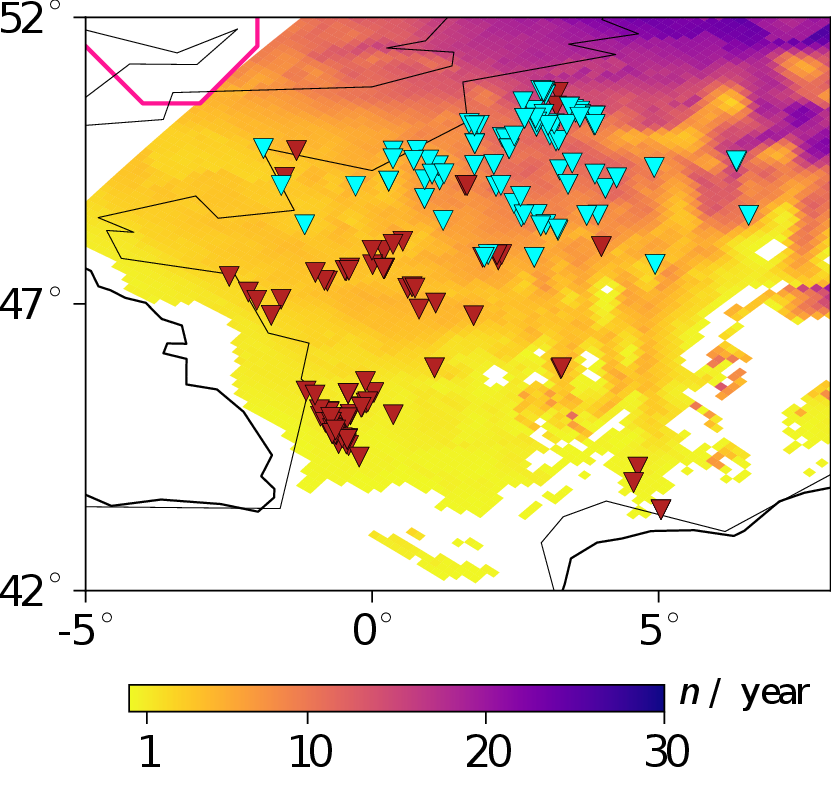
Using global and regional climate model simulations, we investigated the permafrost extent in Europe during the Last Glacial Maximum (LGM) in a recent study [3]. The LGM is a colder and drier period than today and dates back about 20,000 years. For the first time, criteria for possible thermal contraction cracking of the ground [4] are applied to climate model data. In this way, the role of ground thermal contraction cracking in wedge formation during the LGM could be investigated. According to our simulations, it is possible that permafrost existed in northern France and that thermal contraction cracking may have occurred much further south than the simulated permafrost limits. This supports the hypothesis proposed by Andrieux et al. [5], who suggest that sand wedges did not form exclusively in permafrost areas during the LGM, but also in deep seasonally frozen soils. This enables the reconsideration of the role of sand-wedge casts to identify past permafrost regions.
Moreover, we found that a colder and, in terms of proxy data, more realistic version of the LGM climate is achieved when easterly winds are more frequent in the global climate model simulation. Thus, with an appropriate forcing, regional climate model simulations provide an added value in representing both the permafrost distribution and areas where ground thermal contraction cracking occurred during the LGM in France [3].
References:
[1] Intergovernmental Panel on Climate Change (IPCC): IPCC special report on the ocean and cryosphere in a changing climate, available at: https://www.ipcc.ch/srocc/ (last access: 6 December 2021), 2019.
[2] Murton, J. B.: Permafrost and Periglacial Features. Ice wedges and ice wedge casts, in: Encyclopedia of Quaternary Science, edited by: Elias, S. A., vol. 2, Elsevier, Amsterdam, 436–451, 2013.
[3] Stadelmaier, K. H., Ludwig, P., Bertran, P., Antoine, P., Shi, X., Lohmann, G., and Pinto, J. G.: A new perspective on permafrost boundaries in France during the Last Glacial Maximum, Clim. Past, 17, 2559–2576, https://doi.org/10.5194/cp-17-2559-2021, 2021.
[4] Matsuoka, N., Christiansen, H. H., and Watanabe, T.: Ice-wedge polygon dynamics in Svalbard: Lessons from a decade of automated multi-sensor monitoring, Permafrost. Periglac., 29, 210–227, https://doi.org/10.1002/ppp.1985, 2018.
[5] Andrieux, E., Bertran, P., and Saito, K.: Spatial analysis of the French Pleistocene permafrost by a GIS database, Permafrost. Periglac., 27, 17–30, https://doi.org/10.1002/ppp.1856, 2016b.
[6] wikimedia commons, CC BY-SA 3.0, Geograph, https://de.wikipedia.org/wiki/Eiskeil#/media/Datei:Ice_wedge_pseudomorph.jpg.
Kim H. Stadelmaier and Patrick Ludwig, AG “Regional Climate and Weather Hazards”