
How does precip change below the radar beam?
Radar does not miss any precip. Among the advantages of radar measurements is its capability to detect every precipitation without any gap – not only in a single height close to the ground but within the whole troposphere. Each rain gauge network has large gaps here even thunderstorms may be undetected as no gauge is hit. Radar grid points are dense without any gaps.
Ok, this is not completely true. A volume radar measurement consists of several individual sweeps. The antenna of the radar revolves in azimuth and changes the elevation angle from sweep to sweep. To sample the complete troposphere without any gaps the number of needed sweeps led to a very low repetition rate. Furthermore, we have to keep a proper distance to the ground, to avoid ground clutter (echoes from floor, buildings, trees, and so on) to conceal the echo of precipitation.
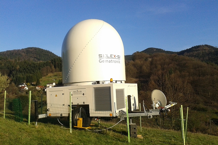
In case of a hill or a mountain between the point of interest and the radar, the lowest available radar measurement may be quite high above the ground. This problem “what happens to precip below our lowest radar measurement?” is quite common, especially in Switzerland. The most important obstacle for our IMK-TRO C-Band radar at Campus North is Northern Black Forest. In cooperation with the Institute for Water and River Basin Management (IWG) we temporarily set up our C-Band Radar in Bühlertal (Northern Black Forest), nearly 50 km south of Campus North (see Fig. 1). From April to September 2014 we measured precipitation nearly down to the ground, avoiding obstacles. The lowest measuring height of the C-Band radar is here at 1500 asl.
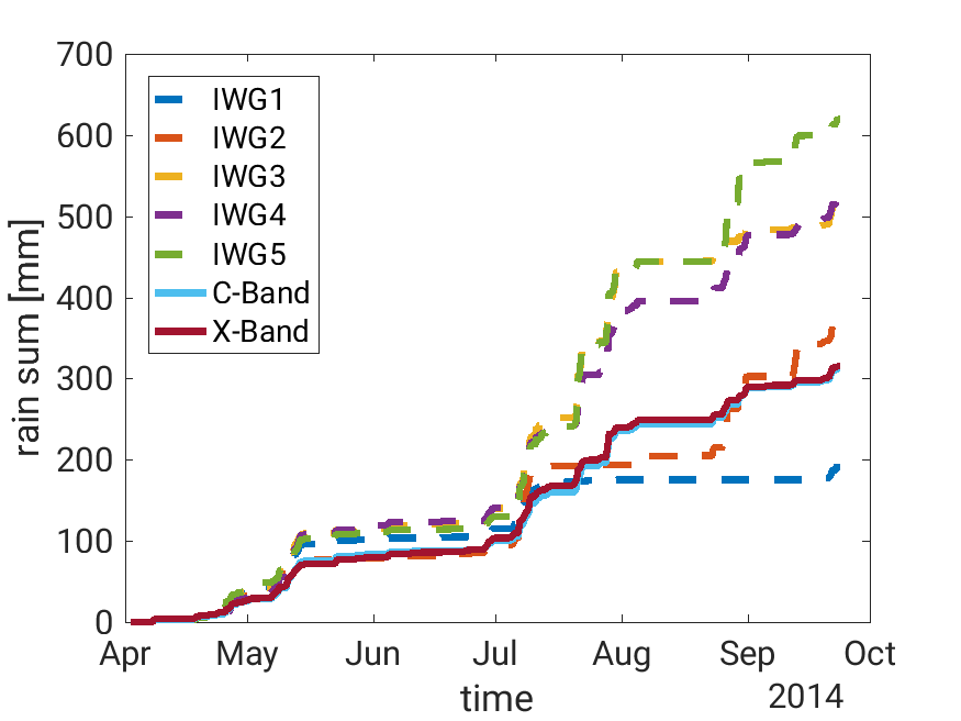
An overview on the measurements is shown in Fig. 2. The light blue curve, showing data of the C-Band radar, is nearly invisible below the dark red curve for the X-Band radar. There could be several reasons to introduce differences between the to radars. Nevertheless, the measurements correspond nearly perfectly. For comparison purpose measurements of five rain gauges are shown, all of them in a distance of less than 5 km from the X-Band radar. These rain gauge measurements are often used as “ground truth” to evaluate radar measurements. The uncertainty of “ground truth” seems to be much worse than that of radar measurements.
From the original radar measurements we determined rain intensities on a very fine grid of 50 m x 50 m x 50 m resolution and compared for each profile the rain intensity in a certain height to that in 1500 m asl. We investigated mainly the eight precipitation events with more than 6 mm/h rain intensity during the measurement period. As comes out, changes in rain intensity with height are moderate. On a vertical distance of one kilometer, instantaneous rain intensities differed by less than 25% (1dB). Main reason for these variations is the inhomogeneity of precip. Drops now observed in 500 m height needed roughly three minutes to fall from 1500 m. In these three minutes horizontal winds shifted the wind to the side.
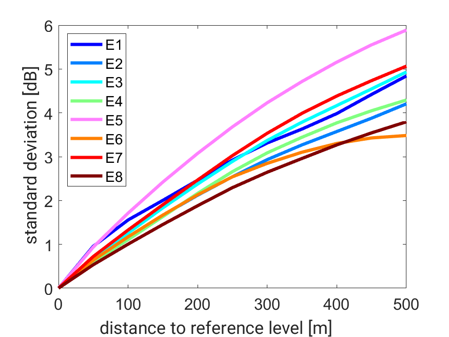
As the average rain intensity within a certain event stays quite constant, it is of greater interest to investigate the instantaneous uncertainty in each layer below the reference height. If we know the rain intensity in 1500 m asl, what is the standard deviation in a deeper layer? The answer is described in Fig. 3 for the eight events (E1 to E8). The variations for an individual profile reach 3 dB to 6 dB (corresponding to a factor 2 to 4 in rain rate) 500 m below the reference level. This seems to be quite a high degree of uncertainty. The problem reduces when keeping in mind, that operational radar measurements do not reach a resolution of 50 m x 50 m. Our own C-Band measurements are available at 500 m x 500 m, German Weather Service (DWD) provides most data at a resolution of a square kilometer or coarser.
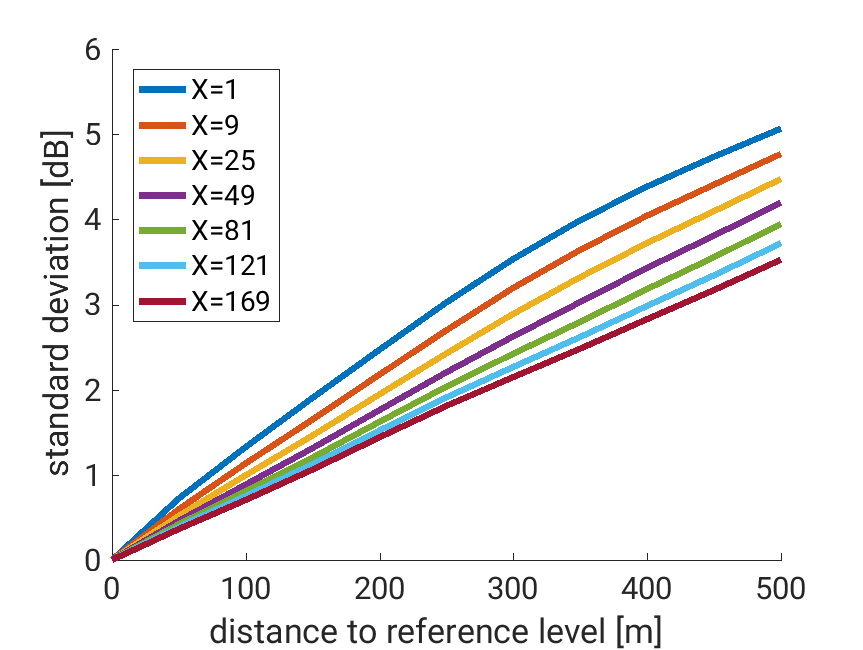
So, we investigated the reduction of uncertainty with increasing area. Fig. 4 shows this effect for profiles averaged over 3x3 profiles, 5x5, … up to 13x13. As the average standard deviation 500 m below reference height of all eight events was near 5 dB, it reduces to 3 dB (factor of 2) when averaged to 650 m x 650 m.
Obviously, the horizontal wind drift needs to be considered if one aims at a high correspondence between “ground truth” and radar measurements.
[Working group: Land Surfaces and Boundary Layer]