
How far into the future can we predict large-scale weather?
Some decades ago, weather forecasts more than two weeks ahead were hard to imagine. Today, certain weather apps claim to be able to tell us whether the planned barbecue party three weeks ahead will or will not drown in rain. Are forecasts like these trustworthy? Indeed, the last few decades were characterized by a rapid increase in computational power and a continuous improvement of numerical weather prediction modeling systems. This has allowed weather forecasting centers to provide forecasts that go beyond two weeks, which is commonly referred to as extended-range or sub-seasonal lead times. Nevertheless, such sub-seasonal forecasts still have moderate to weak skill and are thus a growing field of research. Since the highly chaotic nature of the atmosphere will never allow us to predict a local shower in three weeks from now, sub-seasonal forecasts aim to predict the occurrence probability of large-scale weather conditions, such as weather regimes. These are large-scale weather patterns in the midlatitude atmosphere that persist for several days to weeks and modulate regional surface weather in characteristic ways. As numerous socio-economic sectors such as the energy industry, national health services, or agriculture are strongly influenced by the evolution of such weather regimes [1, 2, 3], it is important to understand how well they can be predicted by state-of-the-art sub-seasonal weather models.
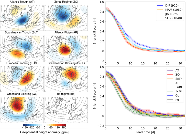
Previous studies have primarily evaluated sub-seasonal weather regime forecasts in winter, when the atmosphere tends to be most predictable. A new study of our research group in collaboration with colleagues at the European Centre for Medium-Range Weather Forecasts (ECMWF) [4] has investigated for the first time how well the sub-seasonal ECMWF (re)forecasts predict a set of seven Atlantic-European weather regimes (Fig. 1, left) throughout the year. A first key finding is that errors in regime occurrence frequency are largest in summer and smallest in winter. Some of these occurrence frequency errors can be explained by consistent errors in regime duration, the number of regime life cycles, and the transitions between regimes. A second key finding is that regimes can be skillfully predicted up to about two weeks ahead. In winter, the regime skill horizon is about 5 days longer than in summer and spring, and about 3 days longer than in fall (Fig. 1, top right). The year-round skill horizon tends to be longest for the Zonal Regime and the Greenland Blocking, which is driven by their high persistence in winter that allows skillful predictions beyond 3 weeks. In contrast, the skill horizon is 3 to 5 days shorter for the European Blocking than for all the other regimes (Fig. 1, bottom right), which is common for all seasons but most pronounced in winter and spring.
The study further elucidates windows of opportunity for enhanced sub-seasonal regime forecast skill. First, predicting a regime within a multi-day lead time window rather than day-by-day increases the skill horizon by several days. Second, global teleconnections varying on slower (seasonal) timescales can provide sub-seasonal predictability in the midlatitudes. Two important such teleconnections arise from the stratospheric polar vortex (SPV) in winter (see also our previous news article), and tropical convection organized in the Madden-Julian Oscillation (MJO). The study shows that the average winter regime skill horizon tends to be enhanced following an anomalously strong SPV but reduced following an anomalously weak SPV at forecast initialization. Likewise, the year-round regime skill tends to be enhanced when tropical convection related to the MJO is located over the Maritime Continent and the western to central Pacific but reduced when it is located over the Indian Ocean.
In conclusion, it is impossible to predict whether a local shower will drown our barbecue party in three weeks. However, we can make valuable estimates on the predominant large-scale weather conditions several weeks ahead, which can be of enormous socio-economic potential. The confidence in these estimates strongly depends on the situation: for instance, it is much more likely to correctly predict a long-lasting mild phase induced by a Zonal Regime or a cold wave induced by a Greenland Blocking in winter than it is to predict a heat wave induced by a European Blocking in summer. Despite these existing windows of opportunity, there is promising potential for further model improvements: for instance, the relatively poor sub-seasonal forecast skill in summer might be improved by further reducing the large-scale circulation errors in summer. Likewise, the skill horizon in winter might be further extended by improving the model’s ability to correctly represent in particular weak SPVs and specific MJO phases. Finally, it is important to better understand and thus model the processes driving blocking over Europe, which is a focus of the ongoing research in our group. Considering the expected increase in heat waves associated with blocking in a changing climate, this should even be put on the top of the priority list.
Dominik Büeler / Julian Quinting / Christian Grams, Large-scale dynamics and predictability group (http://www.imk-tro.kit.edu/7425.php)
[1] Beerli, R., and Grams, C. M., 2019: Stratospheric modulation of the large-scale circulation in the Atlantic-European region and its implications for surface weather events. Q. J. R. Meteorol. Soc., 145, 3732–3750, https://doi.org/10.1002/qj.3653
[2] Charlton-Perez, A. J., Aldridge, R. W., Grams, C. M., and Lee, R., 2019: Winter pressures on the UK health system dominated by the Greenland Blocking weather regime. Weather Clim. Extremes, 25, 100218, https://doi.org/10.1016/j.wace.2019.100218
[3] White, C. J., …, C. M. Grams, D. Büeler, …, et al., 2021: Advances in the application and utility of subseasonal-to-seasonal predictions. Submitted to Bull. Amer. Meteor. Soc.
[4] Büeler, D., Ferranti, L., Magnusson, L., Quinting, J. F., and Grams, C. M., 2021: Year-round sub-seasonal forecast skill for Atlantic-European weather regimes. Submitted to Q. J. R. Meteorol. Soc.