
Resolving Sahelian thunderstorms improves weather forecasts for Europe
The summertime West African Sahel has the worldwide highest degree of thunderstorm organisation into so called mesoscale convective systems. These long-lived, several hundred-kilometre elongated, fast moving systems contribute 90% to the rainfall in the region. All current global weather prediction and climate models represent thunderstorms using simplified parameterisations, which deteriorates the modelled distribution of rainfall from individual storms and the entire West African monsoon circulation.
To investigate if and how this misrepresentation of Sahelian convection affects global weather forecasts, we conducted two types of simulations using ICON, the forecast model of the German Weather Service (DWD). The first (called PARAM) uses a convection parameterisation for the whole globe. The other (called EXPLC) employs a refined horizontal grid over West Africa, meaning that the model captures more details on smaller scales allowing us to turn off the parameterisation. Consequently, Sahelian mesoscale convective systems can be realistically modelled and the impacts on the rest of the globe can be assessed. The results of this study were recently published in Nature Communications (Pante & Knippertz 2019).
Figure 1a shows that explicitly resolving convection reduces the large overestimation in rainfall over the Sahel seen in PARAM and leads to a more realistic diurnal cycle. This large improvement fundamentally changes the simulated meteorology over West Africa through a number of different mechanisms, as described in the paper. The improvements quickly spread out into the neighbouring Atlantic Ocean and then towards Europe on one hand and towards southern Africa and the Indian Ocean on the other hand. This happens along jets and so called waveguides, parts of the atmosphere where forecast information can travel quickly. Ultimately this improves 5–8-day weather forecasts in mid-latitudes, including in particular Europe (Figure 1b). The improvements are seen throughout the lowest about 20km of the atmosphere and in all key meteorological parameters (pressure, temperature, humidity, wind). The computational costs for these experiments are relatively moderate compared to other measures suggested to improve forecasts. The results should motivate operational weather services to target areas with known deficiencies in the tropics more directly.
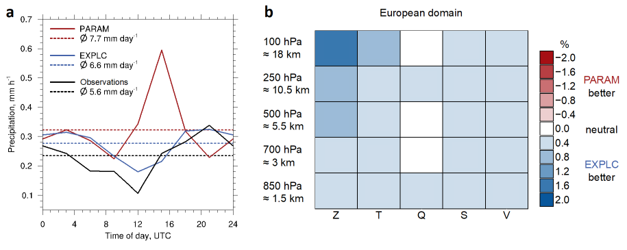
Figure 1 a Diurnal cycle of precipitation in the Sahel. Simulations with explicit convection (blue) match much better with observations (black: satellite-based rainfall estimates) than simulations using a convection parameterization (red). b Forecast improvement over Europe. The root mean squared error (RMSE) is a standard measure of forecast performance. RMSE differences between EXPLC and PARAM reveal the beneficial effect (blueish colours) of explicit convection in the Sahel on 5–8-day weather forecasts over Europe. Geopotential (Z), closely related to atmospheric pressure, temperature (T), specific humidity (Q), wind speed (S) and wind vector (V) show positive response at five different vertical levels between 1.5 and 18 km altitude.
Working group: Atmospheric Dynamics
https://www.imk-tro.kit.edu/5874.php
Authors: G. Pante and P. Knippertz
24 January 2020
Reference: Pante, G. and Knippertz, P.: Resolving Sahelian thunderstorms improves mid-latitude weather forecasts, Nat. Commun., 10, 3487, https://doi.org/10.1038/s41467-019-11081-4, 2019.